Marl Pond
Stephen M. Young
- System
- Lacustrine
- Subsystem
- Natural Lakes And Ponds
- State Protection
- Not Listed
Not listed or protected by New York State.
- Federal Protection
- Not Listed
- State Conservation Status Rank
- S1
Critically Imperiled in New York - Especially vulnerable to disappearing from New York due to extreme rarity or other factors; typically 5 or fewer populations or locations in New York, very few individuals, very restricted range, very few remaining acres (or miles of stream), and/or very steep declines.
- Global Conservation Status Rank
- G3G4
Vulnerable globally, or Apparently Secure - At moderate risk of extinction, with relatively few populations or locations in the world, few individuals, and/or restricted range; or uncommon but not rare globally; may be rare in some parts of its range; possibly some cause for long-term concern due to declines or other factors. More information is needed to assign either G3 or G4.
Summary
Did you know?
Large submerged mats of common stonewort (Chara sp.) can form in marl ponds. At first glance, Chara could be mistaken as a vascular flowering plant, but upon closer look you can see that it is a gray-green branched multicellular algae.
State Ranking Justification
There are probably less than 10 occurrences statewide, and the total acreage is very small. One documented occurrence has good viability and protected on public land. This community is limited to the calcareous areas of the state where marl deposits form on the benthic substrate. The current trend of this community is probably stable for occurrences on protected land, or declining slightly elsewhere due to moderate threats related to development pressure, invasive aquatic plants, and alteration to the natural hydrology.
Short-term Trends
The number and acreage of marl ponds in New York have probably declined slightly or remained stable in recent decades as a result of alteration of natural hydrolgy, invasive species, and development.
Long-term Trends
The number and acreage of marl ponds in New York have probably declined moderately to substantially from historical numbers, likely correlated with the onset of agricultural and residential development.
Conservation and Management
Conservation Overview
Where practical, establish and maintain a natural buffer to reduce storm-water, pollution, and nutrient run-off, while simultaneously capturing sediments before they reach the pond. Buffer width should take into account the erodibility of the surrounding soils, slope steepness, and current land use. Wetlands protected under Article 24 are known as New York State "regulated" wetlands. The regulated area includes the wetlands themselves, as well as a protective buffer or "adjacent area" extending 100 feet landward of the wetland boundary (NYS DEC 1995). If possible, minimize the number and size of impervious surfaces in the surrounding landscape. Avoid habitat alteration within the pond and surrounding landscape. For example, roads and trails should be routed around ponds, and ideally not pass through the buffer area. If the pond must be crossed, then bridges and boardwalks are preferred over filling. Restore past impacts, such as removing obsolete impoundments and ditches in order to restore the natural hydrology. Prevent the spread of invasive exotic species into the pond through appropriate direct management, and by minimizing potential dispersal corridors, such as roads.
Threats
Marl ponds are threatened by development and its associated run-off (e.g., agriculture, residential, roads), recreational overuse (e.g., ATVs, hiking trails), and habitat alteration in the adjacent landscape (e.g., mining, excessive clearing, pollution). Alteration to the natural hydrology is a threat to this community type. Marl ponds are threatened by invasive species, such as reed grass (Phragmites australis ssp. australis) and purple loosestrife (Lythrum salicaria).
Conservation Strategies and Management Practices
Consider how water flows around and into this pond community. Projects that occur near this community must consider the proximity of the development to this pond and the potential for changing how water flows, both above ground and below ground, into this waterbody. Impervious surfaces that rapidly divert water to the wetland should be avoided or minimized. Rapid influxes of surface water dilute the limey, mineral rich waters, decrease the robustness of the native marl pond species, and increase the likelihood of invasion by invasive aquatic plants.
Development and Mitigation Considerations
When considering road construction and other development activities, minimize actions that will change what water carries and how water travels to and from this community, both on the surface and underground. Water traveling over-the-ground as runoff usually carries an abundance of silt, clay, and other particulates during (and often after) a construction project. While still suspended in the water, these particulates make it difficult for aquatic animals to find food; after settling to the bottom of the system, they bury small plants and animals and alter the natural functions of the community in many other ways. Thus, road construction and development activities near this community type should strive to minimize particulate-laden run-off into this community. Water traveling on the ground or seeping through the ground also carries dissolved minerals and chemicals. Road salt, for example, is becoming an increasing problem both to natural communities and as a contaminant in household wells. Fertilizers, detergents, and other chemicals that increase the nutrient levels in wetlands cause algal blooms and eventually an oxygen-depleted environment in which few animals can live. Herbicides and pesticides often travel far from where they are applied and have lasting effects on the quality of the natural community. So, road construction and other development activities should strive to consider how water moves through the ground, the types of dissolved substances these development activities may release, and how to minimize the potential for these dissolved substances to reach this natural community.
Inventory Needs
Inventory known examples of marl pond and survey undocumented ponds adjacent to known occurrences of marl fen and marl pond shore. Need to inventory the plants and animls of all known marl ponds, including invertebrates and fish, needed to update the marl pond community description.
Research Needs
Confident identification of the characteristic marl pond species is needed, especially those involved in the photosynthetic precipitation of calcium carbonate, such as various algae including stoneworts (Chara sp.), mosses, cyanobacteria, and diatoms.
Rare Species
Range
New York State Distribution
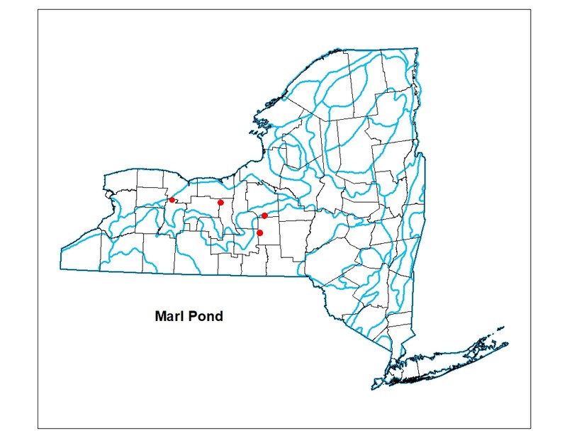
Currently known from Cortland, Livingston, and Seneca counties. The historical range is unknown; it is probably more widespread but always was spotty. No examples were found during an intensive study in the mid-1990s of the Adirondack Nature Conservancy (ANC) Chapter area including the most likely areas of marl such as the Great Lakes Plains of northwest Saint Lawrence County along the Saint Lawrence River and northeast Clinton County along Lake Champlain.
Global Distribution
Marl ponds are reported from New England (VT: Lime Pond in Danville and Marl Pond in Willoughby State Forest in Sutton; NH: Lime or Marl Pond, Columbia); New York: Cortland, Livingston, and Seneca counties.
Best Places to See
- Lime Hollow Nature Center (Cortland County)
Identification Comments
General Description
The aquatic community of a small, shallow spring-fed pond in which the water has a high concentration of calcium; as a result of chemical or photosynthetic removal of carbon dioxide from the water, the calcium precipitates out of the water as calcium carbonate (CaCO3). This calcium carbonate is deposited on the substrate, and forms a marl sediment. Marl is a white-colored precipitate that consists of calcium carbonate mixed with clay. Calcium carbonate levels are typically greater than 50 ppm. Stoneworts (Chara sp.), some other algae, cyanobacteria, and at least one species of moss (Didymodon tophaceus) can be involved in photosynthetic precipitation of calcium carbonate; stoneworts are usually abundant in marl ponds. Marl ponds have very low primary productivity and sparse growth of aquatic macrophytes. Characteristic vascular plants may include pondweeds (Stuckenia filiformis, Potamogeton strictifolius). Certain diatoms may be abundant, but low levels of available plant nutrients restrict growth of other algae and cyanobacteria. Characteristic plankton in nearby states includes calciphilic desmids, cladocerans (Holopedium spp.), and calciphilic rotifers (Brachionus spp.).
Characters Most Useful for Identification
Look for marl deposits on the pond benthic substrate. Marl is a white-colored precipitate that consists of calcium carbonate mixed with clay. Stoneworts (Chara sp.) are typically the dominant submerged, non-vascular plant.
Elevation Range
Known examples of this community have been found at elevations between 471 feet and 1,200 feet.
Best Time to See
This pond community is observable year round, but walking the shoreline is easier in late summer when the water has drawn down.
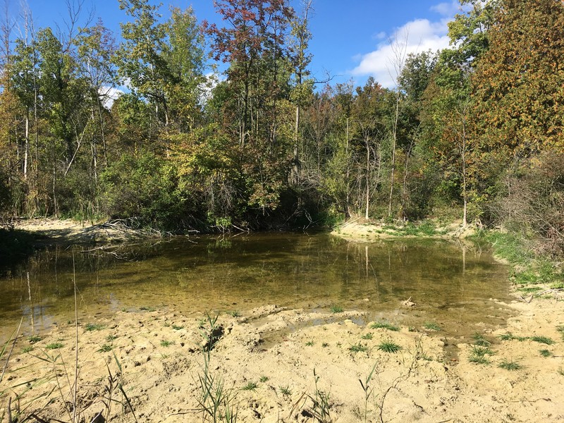
Marl Pond Images
Stephen M. Young
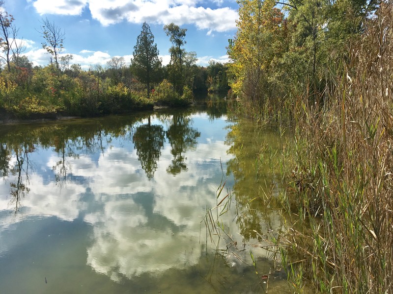
Stephen M. Young
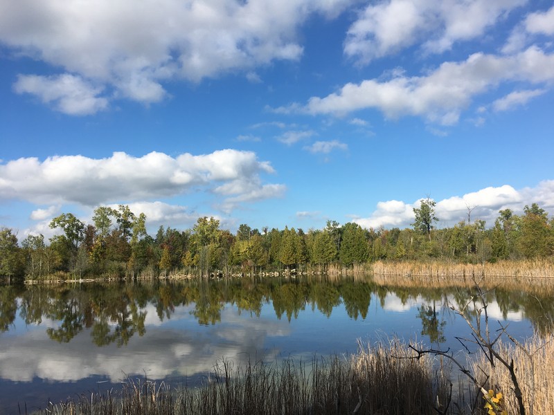
Stephen M. Young
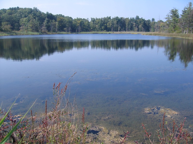
Gregory J. Edinger
Classification
Characteristic Species
-
Nonvascular plants
- Algae
- Chara sp.
- Cyanobacteria
- Didymodon tophaceus
-
Submerged aquatics
- Potamogeton strictifolius (straight-leaved pondweed)
- Stuckenia filiformis (thread-leaved pondweed)
-
Unvegetated
- Brachionus sp.
- Desmids
- Holopedium sp.
Similar Ecological Communities
- Inland salt pond
(guide)
While both are spring-fed ponds and draw down in most years, the water of inland salt ponds is salty from flowing through salt beds in the aquifer and dominated by widgeon grass (Ruppia maritima). Whereas, marl ponds have a high concentration of calcium that precipitates out of the water forming a marl substrate. Stoneworts (Chara sp.) are usually abundant in marl ponds along with other species involved in photosynthetic precipitation of calcium carbonate.
- Marl pond shore
(guide)
Marl ponds and marl pond shores are closely related communities that occupy the same position in the landscape. Marl ponds include the aquatic component of a given pond basin (e.g., the water column and submerged aquatic plants), while the marl pond shore describes the wetland shore that is exposed as the marl pond draws down and is dominated by emergent wetland plants and stranded aquatic vegetation. Small marl ponds may entirely transform to marl pond shore by the end of summer, while larger marl ponds may have a marl pond shore fringe with a permanently flooded central portion.
- Oligotrophic pond
(guide)
While both are medium- to small-sized ponds and can have large patches of stonewort (Chara sp.), oligotrophic ponds have high transparency (Secchi disk depths of 4 to 8 m); are low in plant nutrients (especially low in nitrogen, also low in calcium); the bottom is usually sandy or rocky providing habitat for rosette-leaved aquatics, such as pipewort (Eriocaulon aquaticum) and water lobelia (Lobelia dortmanna). Whereas, marl ponds have a high concentration of calcium that precipitates out of the water forming a marl substrate. Stoneworts (Chara sp.) are usually abundant in marl ponds along with other species involved in photosynthetic precipitation of calcium carbonate. Marl ponds also drawdown in most years revealing a vegetated marl pond shore.
Vegetation
Percent cover
This figure helps visualize the structure and "look" or "feel" of a typical Marl Pond. Each bar represents the amount of "coverage" for all the species growing at that height. Because layers overlap (shrubs may grow under trees, for example), the shaded regions can add up to more than 100%.
Additional Resources
References
Cole, G.A. 1979. Textbook of limnology. The C.V. Mosby Co., Saint Louis, MO.
Dudley, William R. 1886 The Cayuga flora. Part I: A catalogue of the Phaenogamia growing without cultivation in the Cayuga Lake basin. Andrus & Church, Ithaca, NY.
Edinger, G. J., D. J. Evans, S. Gebauer, T. G. Howard, D. M. Hunt, and A. M. Olivero (editors). 2014. Ecological Communities of New York State. Second Edition. A revised and expanded edition of Carol Reschke’s Ecological Communities of New York State. New York Natural Heritage Program, New York State Department of Environmental Conservation, Albany, NY. https://www.nynhp.org/ecological-communities/
Edinger, Gregory J., D.J. Evans, Shane Gebauer, Timothy G. Howard, David M. Hunt, and Adele M. Olivero (editors). 2002. Ecological Communities of New York State. Second Edition. A revised and expanded edition of Carol Reschke's Ecological Communities of New York State. (Draft for review). New York Natural Heritage Program, New York State Department of Environmental Conservation. Albany, NY. 136 pp.
French, J.H. 1860. Gazetteer of the State of New York, Cortland County. R. P. Smith, Syracuse, NY.
Kappel, William M., Todd S. Miller, and Karl K. Hetcher. 2001. Hydrogeology of the Tully Lakes Area in Southern Onondaga and Northern Cortland Counties, New York. U.S. Department of Interior, U.S. Geological Survey, Ithaca, NY.
New York Natural Heritage Program. 2024. New York Natural Heritage Program Databases. Albany, NY.
Nichols, W. F. 2015. Natural Freshwater Lakes and Ponds in New Hampshire: Draft Classification. NH Natural Heritage Bureau, Concord, NH.
Olivero-Sheldon, A. and M.G. Anderson. 2016. Northeast Lake and Pond Classification. The Nature Conservancy, Eastern Conservation Science, Eastern Regional Office. Boston, MA.
Randall, Henry S. 1843. Agriculture of Cortland County. Trans. N. Y. State Agr. Soc., 2:151-62.
Reschke, Carol. 1990. Ecological communities of New York State. New York Natural Heritage Program, New York State Department of Environmental Conservation. Latham, NY. 96 pp. plus xi.
Smith, Henry P. 1885. History of Cortland County, with illustrations and biographical sketches of some of its prominent men and pioneers, edited by H. P. Smith. D. Mason & Co., Syracuse, NY.
Tufts, C.E. 1976. A preliminary inventory of some unique natural areas in Tompkins County, New York. M.S. Thesis. Cornell University, Ithaca, New York.
Wiegand, Karl. M. and Arthur J. Eames. 1925. Flora of the Cayuga Lake Basin, New York. Cornell University Agricultural Experiment Station, Memoir 92. 491 pp.
Links
About This Guide
This guide was authored by: Gregory J. Edinger
Information for this guide was last updated on: March 26, 2024
Please cite this page as:
New York Natural Heritage Program. 2024.
Online Conservation Guide for
Marl pond.
Available from: https://guides.nynhp.org/marl-pond/.
Accessed July 27, 2024.