Marl Pond Shore
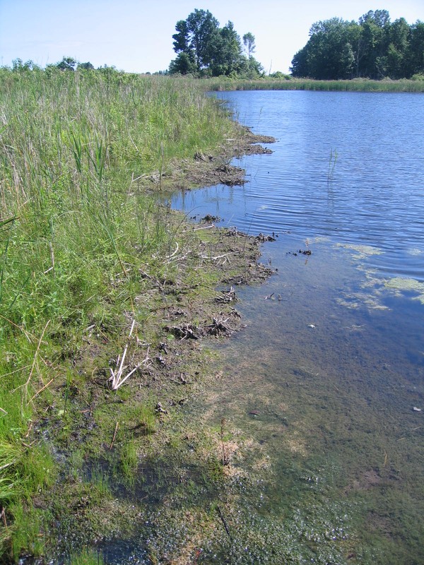
Marl pond shore along the west side of Junius Ponds Newton Ponds.
Gregory J. Edinger
- System
- Palustrine
- Subsystem
- Open Peatlands
- State Protection
- Not Listed
Not listed or protected by New York State.
- Federal Protection
- Not Listed
- State Conservation Status Rank
- S1
Critically Imperiled in New York - Especially vulnerable to disappearing from New York due to extreme rarity or other factors; typically 5 or fewer populations or locations in New York, very few individuals, very restricted range, very few remaining acres (or miles of stream), and/or very steep declines.
- Global Conservation Status Rank
- G3G4
Vulnerable globally, or Apparently Secure - At moderate risk of extinction, with relatively few populations or locations in the world, few individuals, and/or restricted range; or uncommon but not rare globally; may be rare in some parts of its range; possibly some cause for long-term concern due to declines or other factors. More information is needed to assign either G3 or G4.
Summary
Did you know?
Marl pond shores are found at the upper margins of marl ponds and increase in size as the water draws down through the summer and the shore becomes exposed. Small marl ponds may completely draw down and become a marl pond shore temporarily lacking the aquatic pond component, especially during drought periods.
State Ranking Justification
There are probably less than 10 occurrences statewide, and the total acreage is very small. One documented occurrence has good viability and protected on public land. This community is limited to the calcareous areas of the state where marl deposits form on the pond shoreline. The current trend of this community is probably stable for occurrences on protected land, or declining slightly elsewhere due to moderate threats related to development pressure, invasive aquatic plants, and alteration to the natural hydrology.
Short-term Trends
The number and acreage of marl pond shores in New York have probably declined slightly or remained stable in recent decades as a result of alteration of natural hydrolgy, invasive species, and development.
Long-term Trends
The number and acreage of marl ponds in New York have probably declined moderately to substantially from historical numbers, likely correlated with the onset of agricultural and residential development.
Conservation and Management
Conservation Overview
Where practical, establish and maintain a natural buffer to reduce storm-water, pollution, and nutrient run-off, while simultaneously capturing sediments before they reach the pond shore. Buffer width should take into account the erodibility of the surrounding soils, slope steepness, and current land use. Wetlands protected under Article 24 are known as New York State "regulated" wetlands. The regulated area includes the wetlands themselves, as well as a protective buffer or "adjacent area" extending 100 feet landward of the wetland boundary (NYS DEC 1995). If possible, minimize the number and size of impervious surfaces in the surrounding landscape. Avoid habitat alteration within the pond and surrounding landscape. For example, roads and trails should be routed around ponds, and ideally not pass through the buffer area. If the pond must be crossed, then bridges and boardwalks are preferred over filling. Restore past impacts, such as removing obsolete impoundments and ditches in order to restore the natural hydrology. Prevent the spread of invasive exotic species into the pond through appropriate direct management, and by minimizing potential dispersal corridors, such as roads.
Threats
Marl pond shores are threatened by development and its associated run-off (e.g., agriculture, residential, roads), recreational overuse (e.g., ATVs, hiking trails), and habitat alteration in the adjacent landscape (e.g., mining, excessive clearing, pollution). Alteration to the natural hydrology is a threat to this community type. Marl ponds are threatened by invasive species, such as reed grass (Phragmites australis ssp. australis) and purple loosestrife (Lythrum salicaria).
Conservation Strategies and Management Practices
Consider how water flows around and into this wetland. Projects that occur near this community must consider the proximity of the development to this wetland and the potential for changing how water flows, both above ground and below ground, into this wetland. Concerning the proximity to the wetland, terrestrial buffers provide nesting habitat for resident salamanders, frogs, and turtles and additional food sources for locally nesting birds. Impervious surfaces that rapidly divert water to the wetland should be avoided or minimized.
Development and Mitigation Considerations
When considering road construction and other development activities, minimize actions that will change what water carries and how water travels to and from this community, both on the surface and underground. Water traveling over-the-ground as runoff usually carries an abundance of silt, clay, and other particulates during (and often after) a construction project. While still suspended in the water, these particulates make it difficult for aquatic animals to find food; after settling to the bottom of the system, they bury small plants and animals and alter the natural functions of the community in many other ways. Thus, road construction and development activities near this community type should strive to minimize particulate-laden run-off into this community. Water traveling on the ground or seeping through the ground also carries dissolved minerals and chemicals. Road salt, for example, is becoming an increasing problem both to natural communities and as a contaminant in household wells. Fertilizers, detergents, and other chemicals that increase the nutrient levels in wetlands cause algal blooms and eventually an oxygen-depleted environment in which few animals can live. Herbicides and pesticides often travel far from where they are applied and have lasting effects on the quality of the natural community. So, road construction and other development activities should strive to consider how water moves through the ground, the types of dissolved substances these development activities may release, and how to minimize the potential for these dissolved substances to reach this natural community.
Inventory Needs
Inventory known examples of marl pond shores and survey undocumented pond shores adjacent to known occurrencs marl pond.
Research Needs
Research is needed to document the seasonal and multi-year hydrological regime and its effect on marl pond shore vegetation. More data are needed to determine if this community would be better classified as an open mineral soil wetland instead of peatland. More data are needed to clearly separate this community from inland calcareous lake shore. Data on characteristic fauna are needed.
Rare Species
Range
New York State Distribution
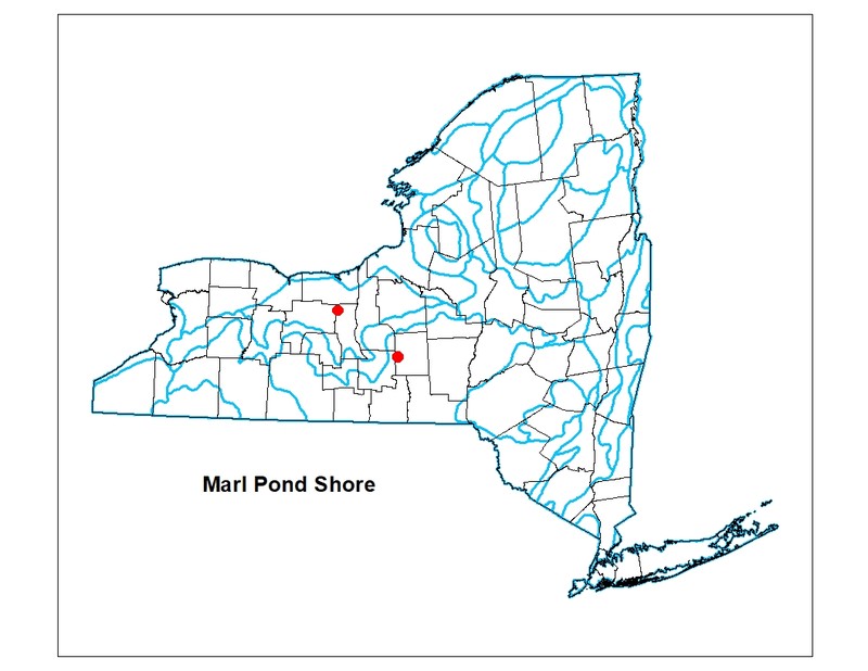
Currently known from Cortland, Livingston, and Seneca counties. The historical range is unknown; it is probably more widespread but always was spotty. No examples were found during an intensive study in the mid-1990s of the Adirondack Nature Conservancy (ANC) Chapter area including the most likely areas of marl such as the Great Lakes Plains of northwest Saint Lawrence County along the Saint Lawrence River and northeast Clinton County along Lake Champlain.
Global Distribution
Marl ponds are reported from New England (VT: Lime Pond in Danville and Marl Pond in Willoughby State Forest in Sutton; NH: Lime or Marl Pond, Columbia); New York: Cortland, Livingston, and Seneca counties. Marl ponds extend west to Michigan, such as Parlemee Lake in Dickinson County. It is uncertain what proportion of these ponds have a well-developed pond shore.
Best Places to See
- Lime Hollow Nature Center (Cortland County)
Identification Comments
General Description
The marly shore wetland of an inland marl pond. Marl pond shores typically occur on inactive lacustrine marl deposits in kettleholes. Marl is a white-colored precipitate that consists of calcium carbonate mixed with clay. Water levels may fluctuate seasonally; the substrate is usually saturated. Vegetation is sparse. Characteristic species include tufted hairgrass (Deschampsia cespitosa), sedge (Carex viridula), Indian hemp (Apocynum cannabinum), spikerush (Eleocharis palustris), silverweed (Argentina anserina), boneset (Eupatorium perfoliatum), cardinal flower (Lobelia cardinalis), water-horehound (Lycopus virginicus), field mint (Mentha arvensis), and water smartweed (Persicaria amphibia).
Characters Most Useful for Identification
Look for marl deposits on the shore vegetation and gravel substrate. Marl is a white-colored precipitate that consists of calcium carbonate mixed with clay. Also look for a mat of stoneworts (Chara sp.) may be deposited on the shore as the marl pond draws down through the summer.
Elevation Range
Known examples of this community have been found at elevations between 472 feet and 1,180 feet.
Best Time to See
This pond community is observable year round, but walking the shoreline is easier in late summer when the water has drawn down.
Marl Pond Shore Images
Gregory J. Edinger
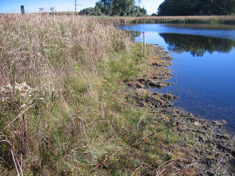
Gregory J. Edinger
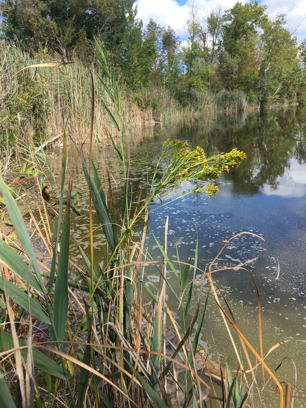
Stephen M. Young
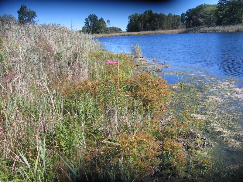
Gregory J. Edinger
Classification
International Vegetation Classification Associations
This New York natural community encompasses all or part of the concept of the following International Vegetation Classification (IVC) natural community associations. These are often described at finer resolution than New York's natural communities. The IVC is developed and maintained by NatureServe.
- Tufted Hairgrass - Little Green Sedge Riverscour Wet Meadow (CEGL006969)
Characteristic Species
-
Epiphytes
- Schoenoplectus tabernaemontani (soft-stemmed bulrush)
-
Herbs
- Agalinis paupercula (small-flowered agalinis)
- Apocynum cannabinum (Indian-hemp)
- Bidens frondosa (devil's beggar-ticks)
- Bidens tripartita
- Carex viridula
- Cyperus strigosus (false yellow nut sedge)
- Deschampsia cespitosa (tufted hair grass)
- Eleocharis flavescens var. olivacea (olive-fruited spike-rush)
- Eleocharis obtusa var. obtusa (blunt spike-rush)
- Eleocharis palustris (common spike-rush)
- Eupatorium perfoliatum (boneset)
- Lobelia cardinalis (cardinal flower)
- Lycopus virginicus (Virginia bugleweed, Virginia water-horehound)
- Lythrum salicaria (purple loosestrife)
- Mentha arvensis (field mint)
- Persicaria amphibia
- Phragmites australis (old world reed grass, old world phragmites)
- Potentilla anserina ssp. anserina (common silverweed)
- Schoenoplectus acutus var. acutus (hard-stemmed bulrush)
-
Nonvascular plants
- Chara sp.
Similar Ecological Communities
- Coastal plain pond shore
(guide)
These pond shore communities are similar in that they are both located at the upper fringe of ponds that usually draw down in most years. However, marl pond shores have high pH, marl deposits on gravel substrate and vegetation, with a mat of stranded stoneworts (Chara sp.), located in the limestone areas of central NY. Whereas, coastal plain pond shores are more acidic, lack marl deposits and stoneworts, and are restricted to sandy areas of Long Island.
- Inland calcareous lake shore
(guide)
These shore communities are similar in that they are both located at the upper fringe of waterbodies that usually draw down in most years. However, marl pond shores are associated with smaller marl ponds that have marl deposits on the substrate and vegetation, with a mat of stranded stoneworts (Chara sp.), and dominated by tufted hair grass (Deschampsia cespitosa). Whereas, inland calcareous lake shores are associated with larger lakes, lack marl and stoneworts, and dominated by freshwater cordrass (Spartina pectinata) and various bulrushes (Schoenoplectus spp.)
- Marl pond
(guide)
Marl ponds and marl pond shores are closely related communities that occupy the same position in the landscape. Marl ponds include the aquatic component of a given pond basin (e.g., the water column and submerged aquatic plants), while the marl pond shore describes the wetland shore that is exposed as the marl pond draws down and is dominated by emergent wetland plants and stranded aquatic vegetation. Small marl ponds may entirely transform to marl pond shore by the end of summer, while larger marl ponds may have a marl pond shore fringe with a permanently flooded central portion.
- Vernal pool
(guide)
These communities are similar in that they are associated with relatively small waterbodies that usually draw down in most years. However, marl pond shores have marl deposits on gravel substrate and vegetation, often with a mat of stranded stoneworts (Chara sp.), and lacking a continuous leaf litter substrate. Whereas, vernal pools lack marl deposits and stoneworts, and have overhanging trees that usually produce a continuous leaf litter substrate.
Vegetation
Percent cover
This figure helps visualize the structure and "look" or "feel" of a typical Marl Pond Shore. Each bar represents the amount of "coverage" for all the species growing at that height. Because layers overlap (shrubs may grow under trees, for example), the shaded regions can add up to more than 100%.
Additional Resources
References
Cowardin, L.M., V. Carter, F.C. Golet, and E.T. La Roe. 1979. Classification of wetlands and deepwater habitats of the United States. U.S. Fish and Wildlife Service. Washington, D.C. 131 pp.
Dudley, William R. 1886 The Cayuga flora. Part I: A catalogue of the Phaenogamia growing without cultivation in the Cayuga Lake basin. Andrus & Church, Ithaca, NY.
Edinger, G. J., D. J. Evans, S. Gebauer, T. G. Howard, D. M. Hunt, and A. M. Olivero (editors). 2014. Ecological Communities of New York State. Second Edition. A revised and expanded edition of Carol Reschke’s Ecological Communities of New York State. New York Natural Heritage Program, New York State Department of Environmental Conservation, Albany, NY. https://www.nynhp.org/ecological-communities/
Edinger, Gregory J., D.J. Evans, Shane Gebauer, Timothy G. Howard, David M. Hunt, and Adele M. Olivero (editors). 2002. Ecological Communities of New York State. Second Edition. A revised and expanded edition of Carol Reschke's Ecological Communities of New York State. (Draft for review). New York Natural Heritage Program, New York State Department of Environmental Conservation. Albany, NY. 136 pp.
French, J.H. 1860. Gazetteer of the State of New York, Cortland County. R. P. Smith, Syracuse, NY.
Kappel, William M., Todd S. Miller, and Karl K. Hetcher. 2001. Hydrogeology of the Tully Lakes Area in Southern Onondaga and Northern Cortland Counties, New York. U.S. Department of Interior, U.S. Geological Survey, Ithaca, NY.
New York Natural Heritage Program. 2024. New York Natural Heritage Program Databases. Albany, NY.
New York State Department of Environmental Conservation. 1995. Freshwater Wetlands: Delineation Manual. July 1995. New York State Department of Environmental Conservation. Division of Fish, Wildlife, and Marine Resources. Bureau of Habitat. Albany, NY.
Randall, Henry S. 1843. Agriculture of Cortland County. Trans. N. Y. State Agr. Soc., 2:151-62.
Reschke, Carol. 1990. Ecological communities of New York State. New York Natural Heritage Program, New York State Department of Environmental Conservation. Latham, NY. 96 pp. plus xi.
Smith, Henry P. 1885. History of Cortland County, with illustrations and biographical sketches of some of its prominent men and pioneers, edited by H. P. Smith. D. Mason & Co., Syracuse, NY.
Tufts, C.E. 1976. A preliminary inventory of some unique natural areas in Tompkins County, New York. M.S. Thesis. Cornell University, Ithaca, New York.
Wiegand, Karl. M. and Arthur J. Eames. 1925. Flora of the Cayuga Lake Basin, New York. Cornell University Agricultural Experiment Station, Memoir 92. 491 pp.
Links
About This Guide
This guide was authored by: Gregory J. Edinger
Information for this guide was last updated on: March 26, 2024
Please cite this page as:
New York Natural Heritage Program. 2024.
Online Conservation Guide for
Marl pond shore.
Available from: https://guides.nynhp.org/marl-pond-shore/.
Accessed July 27, 2024.