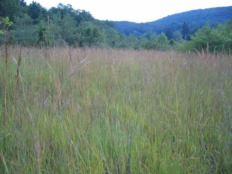
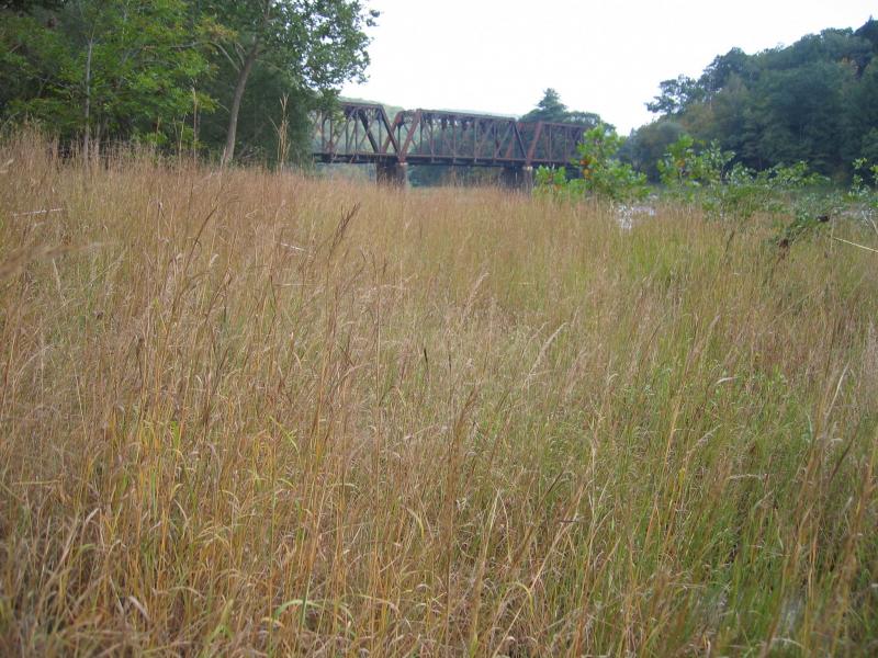
Floodplain Grassland
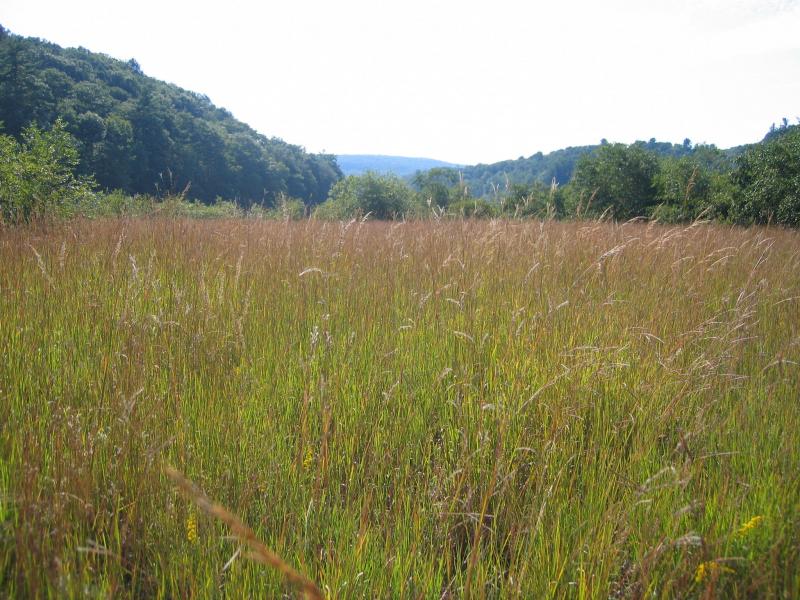
Floodplain grassland community on the Delaware River
Gregory J. Edinger
- System
- Terrestrial
- Subsystem
- Open Uplands
- State Protection
- Not Listed
Not listed or protected by New York State.
- Federal Protection
- Not Listed
- State Conservation Status Rank
- S3
Vulnerable in New York - Vulnerable to disappearing from New York due to rarity or other factors (but not currently imperiled); typically 21 to 80 populations or locations in New York, few individuals, restricted range, few remaining acres (or miles of stream), and/or recent and widespread declines.
- Global Conservation Status Rank
- G3G4
Vulnerable globally, or Apparently Secure - At moderate risk of extinction, with relatively few populations or locations in the world, few individuals, and/or restricted range; or uncommon but not rare globally; may be rare in some parts of its range; possibly some cause for long-term concern due to declines or other factors. More information is needed to assign either G3 or G4.
Summary
Did you know?
Floodplain grasslands have the "Big Four" grasses of the tallgrass prairie that once stretched from Minnesota to Texas: big bluestem (Andropogon gerardii), Indian grass (Sorghastrum nutans), switch grass (Panicum virgatum), and little bluestem (Schizachyrium scoparium). At almost 40,000 acres, the largest protected remenant of tallgrass prairie in world can be seen at the Joseph H. Williams Tallgrass Prairie Preserve in Oklahoma.
State Ranking Justification
There are an estimated 20 to 80 occurrences statewide. Very few documented occurrences have good viability and very few are protected on public land or private conservation land. This community is limited to the upper reaches of large rivers throughout upstate New York, north of the Coastal Lowland ecozone, and there are only a few good quality examples in New York. The current trend of this community is probably stable for occurrences on public land or private conservation land, or declining slightly elsewhere due to moderate threats that include shoreline development (especially roads and bridges) and invasive species.
Short-term Trends
The number and acreage of floodplain grasslands in New York have probably declined slightly in recent decades as a result of shoreline development, trampling by visitors, and invasive species.
Long-term Trends
The number and acreage of floodplain grasslands in New York have probably declined moderately from historical numbers likely correlated with past shoreline development, trampling by visitors, and invasive species.
Conservation and Management
Threats
Floodplain grasslands are threatened by development (e.g., residential, agricultural, industrial), either directly within the community or in the surrounding landscape. Structures built along the shoreline are a particular threat to this community (e.g., riprap, boat launches, cabins). Other threats include habitat alteration (e.g., road crossings, excessive logging in adjacent uplands, gravel mining in river channel), and relatively minor recreational overuse (e.g., boating, ATVs, trampling by visitors, campgrounds, picnic areas, fishing, trash dumping). Threats to the adjacent river may apply to the grasslands (e.g., pollution, nutrient loading, sedimentation, impoundments/flooding, water release for rafting). Several floodplain grassland are threatened by invasive species, such as purple loosestrife (Lythrum salicaria), reed canary grass (Phalaris arundinacea), reedgrass (Phragmites australis ssp. australis ), Canada bluegrass (Poa compressa), spotted knapweed (Centaurea biebersteinii), and Japanese knotweed (Fallopia japonica).
Conservation Strategies and Management Practices
Where practical, establish and maintain a natural forested buffer to reduce storm-water, pollution, and nutrient run-off, while simultaneously capturing sediments before they reach the grassland. Avoid habitat alteration along the shoreline and surrounding landscape. Restore floodplain grasslands that have been unnaturally disturbed (e.g., remove obsolete impoundments in order to restore the natural hydrology). Prevent the spread of invasive exotic species into the riverside ice meadow through appropriate direct management, and by minimizing potential dispersal corridors, such as roads and bridges.
Development and Mitigation Considerations
Where practical, establish and maintain a natural riparian buffer to filter storm-water, pollution, and nutrient run-off from surrounding uplands and to capture sediments before they reach the floodplain grassland. Avoid habitat alteration along the shoreline and in surrounding landscape. Minimize potential dispersal corridors for exotic species, such as roads and bridges. Maintain or restore the natural flood and ice scour regime.
Inventory Needs
Survey for occurrences statewide to advance documentation and classification of floodplain grasslands. Continue searching for large sites in good condition (A- to AB-ranked).
Research Needs
Research is needed to evaluate floodplains and shorelines dominated by shrubs and small trees as a potential new communuty tentatively called "floodplain shrubland" separate from floodplain grassland and floodplain forest. Research the role flood regime and ice scour pattern have on the succession and interelation of these floodplain communities.
Rare Species
Range
New York State Distribution
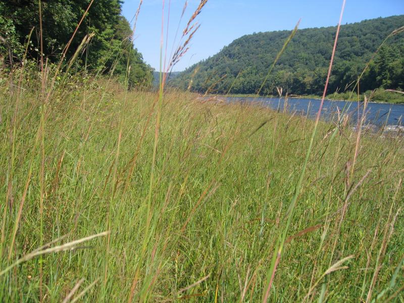
Floodplain grasslands occur as discontinuous patches along the upper reaches of large rivers throughout upstate New York, north of the Coastal Lowland ecozone.
Global Distribution
This community is possibly limited to the northeastern U.S. and southern Canada, ranging from Pennsylvania to Quebec, but currently excluding Maine and New Bruswick.
Best Places to See
- Cherry Island Wildlife Management Area (Orange County)
Identification Comments
General Description
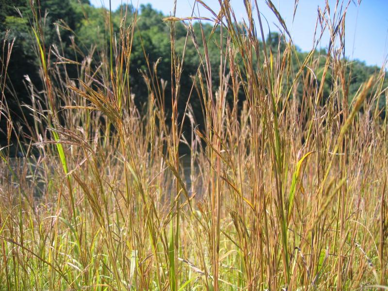
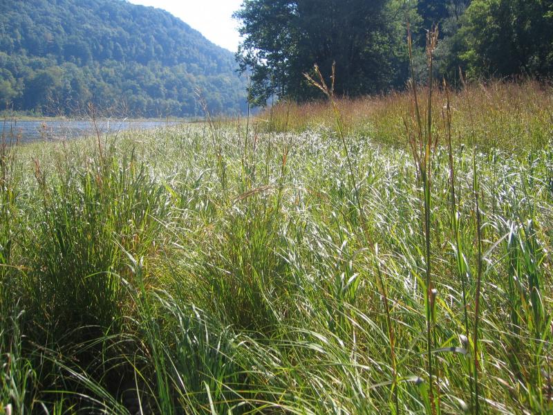
This community is somewhat densely vegetated, tall grassland that occurs on the floodplains along the upper reaches of larger confined rivers. This community occurs on relatively stable sand/gravel or cobble substrate that is often visible between the clump forming grasses. These floodplain shores and islands are typically broad and the soil is coarse and dry. These grasslands are subject to flooding and ice scour, but ice floes usually do not persist into spring as in riverside ice meadows.
Characters Most Useful for Identification
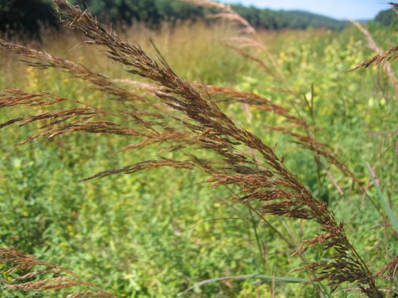
The dominant grasses are big bluestem (Andropogon gerardii), Indian grass (Sorghastrum nutans), and switch grass (Panicum virgatum). Other grasses with lower percent cover include little bluestem (Schizachyrium scoparium), reed canary grass (Phalaris arundinacea), deer tongue grass (Dichanthelium clandestinum), and freshwater cordgrass (Spartina pectinata). By late summer these grasses usually cover from 30% to ideally 50% or more of this community. Other characteristic herbs include goldenrods (Solidago juncea, S. gigantea, S. rugosa, S. canadensis, S. nemoralis, Euthamia graminifolia), false indigo (Baptisia tinctoria), marsh fern (Thelypteris palustris), frostweed (Helianthemum canadense), bushclover (Lespedeza capitata), starry Solomon's-seal (Maianthemum stellatum), American germander (Teucrium canadense), spreading dogbane (Apocynum androsaemifolium), St. John's-wort (Hypericum mutilum), butterflyweed (Asclepias tuberosa), hairy-fruited sedge (Carex trichocarpa), giant St. John's-wort (Hypericum ascyron), and wool grass (Scirpus cyperinus).
Elevation Range
Known examples of this community have been found at elevations between 40 feet and 740 feet.
Best Time to See
Late summer (August-September) is an excellent time of year to canoe the Upper Delaware Scenic and Recreational River and see the tall grasses along the shoreline that are characteristic of this community.
Floodplain Grassland Images
Gregory J. Edinger
Gregory J. Edinger
Gregory J. Edinger
Gregory J. Edinger
Gregory J. Edinger
Gregory J. Edinger
Gregory J. Edinger
Classification
International Vegetation Classification Associations
This New York natural community encompasses all or part of the concept of the following International Vegetation Classification (IVC) natural community associations. These are often described at finer resolution than New York's natural communities. The IVC is developed and maintained by NatureServe.
- Sandcherry / Big Bluestem - Indiangrass Riverscour Wet Meadow (CEGL006518)
NatureServe Ecological Systems
This New York natural community falls into the following ecological system(s). Ecological systems are often described at a coarser resolution than New York's natural communities and tend to represent clusters of associations found in similar environments. The ecological systems project is developed and maintained by NatureServe.
- Central Appalachian River Floodplain (CES202.608)
Characteristic Species
-
Trees > 5m
- Betula nigra (river birch)
- Platanus occidentalis (eastern sycamore)
- Populus deltoides ssp. deltoides (eastern cottonwood)
-
Shrubs 2 - 5m
- Amorpha fruticosa (false indigo-bush)
- Cornus racemosa (gray dogwood, red-panicled dogwood)
- Crataegus sp.
- Platanus occidentalis (eastern sycamore)
- Quercus ilicifolia (scrub oak, bear oak)
- Salix eriocephala (heart-leaved willow, Missouri willow)
-
Shrubs < 2m
- Betula nigra (river birch)
- Cornus racemosa (gray dogwood, red-panicled dogwood)
- Elaeagnus umbellata (autumn-olive)
- Gaylussacia baccata (black huckleberry)
- Ilex verticillata (common winterberry)
- Lyonia ligustrina var. ligustrina (maleberry)
- Physocarpus opulifolius (ninebark)
- Platanus occidentalis (eastern sycamore)
- Prunus pumila var. depressa (dwarf cherry)
- Quercus ilicifolia (scrub oak, bear oak)
- Rhododendron periclymenoides (pinxter-flower)
- Robinia pseudoacacia (black locust)
- Rosa carolina ssp. carolina (eastern pasture rose)
- Rosa multiflora (multiflora rose)
- Rubus allegheniensis (common blackberry)
- Rubus hispidus (swamp dewberry)
- Rubus sp.
- Salix sp.
- Spiraea alba var. latifolia (broad-leaved meadow-sweet)
- Vaccinium angustifolium (common lowbush blueberry)
- Vaccinium pallidum (hillside blueberry)
-
Vines
- Parthenocissus quinquefolia (Virginia-creeper)
- Toxicodendron radicans ssp. radicans (eastern poison-ivy)
-
Herbs
- Achillea millefolium (yarrow)
- Agrostis sp.
- Alliaria petiolata (garlic mustard)
- Pycnanthemum sp.
- Schizachyrium scoparium
- Scirpus cyperinus (common wool-grass)
- Solanum carolinense var. carolinense (horse-nettle)
- Solidago gigantea (swamp goldenrod)
- Solidago juncea (early goldenrod)
- Solidago nemoralis ssp. nemoralis (gray goldenrod)
- Solidago rugosa var. rugosa (common wrinkle-leaved goldenrod)
- Sorghastrum nutans (Indian grass)
- Spartina pectinata (prairie cord grass)
- Teucrium canadense var. canadense
- Thelypteris palustris var. pubescens (marsh fern)
- Verbena hastata (blue vervain)
Similar Ecological Communities
- Cobble shore
(guide)
While both communities have a cobblestone substrate, floodplain grasslands are more densely vegetated and dominated by tall grasses, whereas cobble shores tend to be sparsely vegetated and are dominated by scattered low growing annuals, such as knotweeds (Persicaria sp.).
- Floodplain forest
(guide)
While both communities occur on river floodplains, floodplain grasslands are more frequently scoured and dominated by tall grasses, whereas floodplain forests have a closed canopy of large, multi-trunked trees that can tolerate seasonal flooding, such as silver maple and sycamore.
- Riverside ice meadow
(guide)
Riverside ice meadows tend to be more alkaline and have greater plant diversity compared to floodplain grasslands. Floodplain grasslands are more acidic and dominated by a few tall grasses. Riverside ice meadows develop in areas where frazil ice accummulates on the river shore and often persists into late spring, whereas floodplain grasslands are usually ice free at spring time in most years
- Riverside sand/gravel bar
(guide)
Riverside sand/gravel bars are usually unvegetated or very sparsely vegetated and more frequently flooded, compared to floodplain grasslands that are more densely vegetated by tall grasses and less frequently flooded.
- Shoreline outcrop
(guide)
While both communities occur along river shores and share several species, floodplain grasslands are more densely vegetated and dominated by tall grasses, whereas shoreline outcops are sparsely vegetated with large areas of exposed bedrock.
- Successional northern sandplain grassland
(guide)
While these communities may share similar species, successional northern sandplain grasslands occur on sandy soil and are dominated by bluestem (Schizachyrium scoparium), hairgrass (Avenella flexuosa), Pennsylvania sedge (Carex pensylvanica), poverty grass (Danthonia spicata), and panic grasses (Dichanthelium spp.). Floodplain grasslands occur on relatively stable sand/gravel or cobble substrate along rivers and are dominated by big bluestem (Andropogon gerardii), Indian grass (Sorghastrum nutans), and switch grass (Panicum virgatum).
Vegetation
Percent cover
This figure helps visualize the structure and "look" or "feel" of a typical Floodplain Grassland. Each bar represents the amount of "coverage" for all the species growing at that height. Because layers overlap (shrubs may grow under trees, for example), the shaded regions can add up to more than 100%.
Additional Resources
References
Edinger, G. J., D. J. Evans, S. Gebauer, T. G. Howard, D. M. Hunt, and A. M. Olivero (editors). 2014. Ecological Communities of New York State. Second Edition. A revised and expanded edition of Carol Reschke’s Ecological Communities of New York State. New York Natural Heritage Program, New York State Department of Environmental Conservation, Albany, NY. https://www.nynhp.org/ecological-communities/
Fike, J. 1999. Terrestrial and Palustrine Plant Communities of Pennsylvania. Pennsylvania Natural Diversity Inventory, Harrisburg, PA.
NatureServe. 2015. NatureServe Explorer: An online encyclopedia of life [web application]. Version 7.1. NatureServe, Arlington, Virginia. Available http://www.natureserve.org/explorer.
New York Natural Heritage Program. 2024. New York Natural Heritage Program Databases. Albany, NY.
Perles, S. J., G. S. Podniesinski, M. Furedi, B. A. Eichelberger, A. L. Feldmann, G.J. Edinger, E. Eastman, and L. A. Sneddon. 2008. Vegetation Classification and Mapping at Upper Delaware Scenic and Recreational River. Technical Report NPS/NER/NRTR—2008/133. National Park Service. Philadelphia, PA.
Links
- Big Bluestem - Indian-grass Floodplain Grassland (Pennsylvania Natural Heritage Program)
- Joseph H. Williams Tallgrass Prairie Preserve, Oklahoma (TNC)
- Tallgrass Prairie National Preserve, Kansas Flint Hills (NPS)
- The "BIG FOUR" grasses of the tallgrass prairie ecosystem (NPS)
- Vegetation Mapping Inventory Project for Upper Delaware Scenic and Recreational River (NPS)
About This Guide
This guide was authored by: Gregory J. Edinger
Information for this guide was last updated on: November 2, 2023
Please cite this page as:
New York Natural Heritage Program. 2024.
Online Conservation Guide for
Floodplain grassland.
Available from: https://guides.nynhp.org/floodplain-grassland/.
Accessed July 26, 2024.