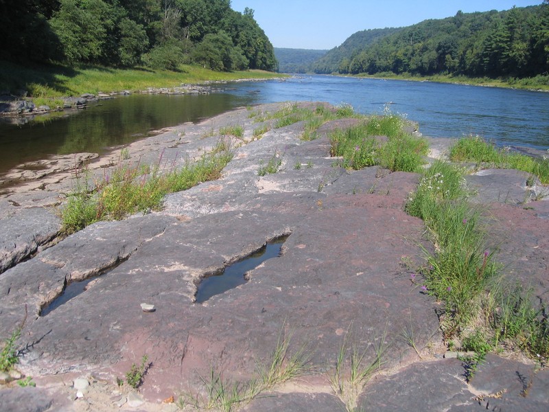
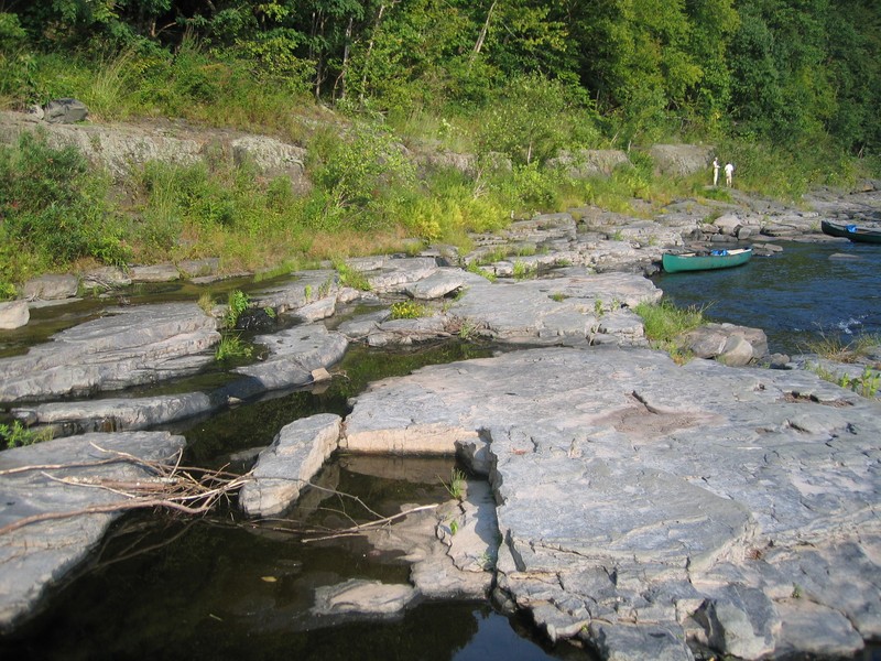
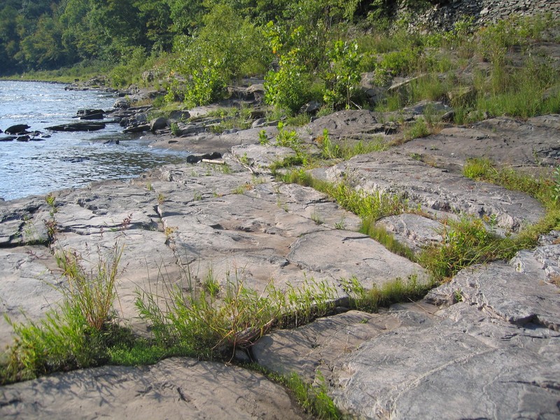
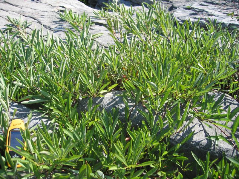
Shoreline Outcrop
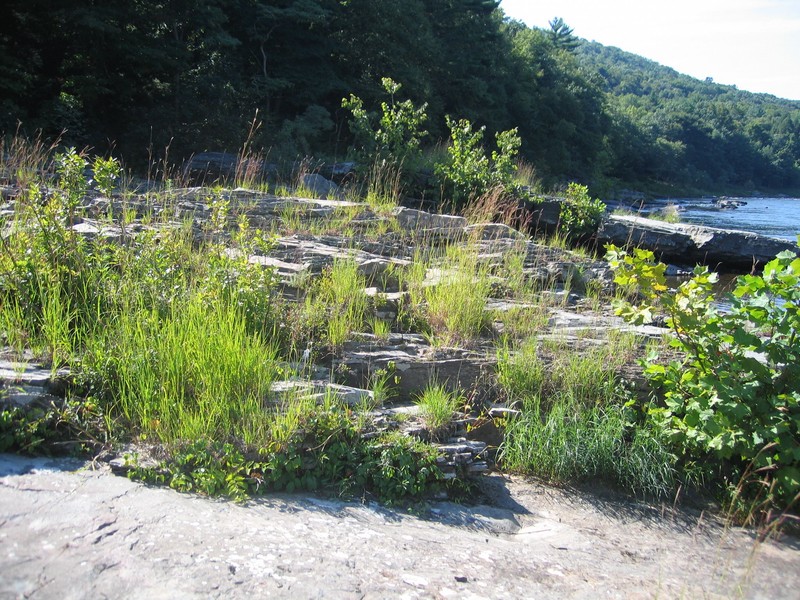
Shoreline outcrop community on the Delaware River
Gregory J. Edinger
- System
- Terrestrial
- Subsystem
- Open Uplands
- State Protection
- Not Listed
Not listed or protected by New York State.
- Federal Protection
- Not Listed
- State Conservation Status Rank
- S3S4
Vulnerable in New York, or Apparently Secure - Vulnerable to disappearing from New York (but not currently imperiled), with relatively few populations or locations, few individuals, and/or restricted range; or uncommon but not rare in New York; may be rare in some parts of the state; possibly some cause for long-term concern due to declines or other factors. More information is needed to assign either S3 or S4.
- Global Conservation Status Rank
- G5
Secure globally - Common in the world; widespread and abundant (but may be rare in some parts of its range).
Summary
Did you know?
Shoreline outcrops can be sparsely vegetated and species rich at the same time. Plants take root in the cracks of the bedrock where soil accumulates and those not in the cracks are eventually scoured away. However, several dozen species of plants can survive in those cracks (see partial plant list below) making this community very diverse despite the low percent cover of vegetation.
State Ranking Justification
There are a couple thousand occurrences statewide. A few documented occurrences have good viability and many are protected on public land or private conservation land. This community is limited to areas along rivers and lakes with non-calcareous bedrock outcrop and there are only a few high quality examples currently documented. The current trend of this community is probably stable for occurrences on public land, or declining slightly elsewhere due to moderate threats that include shoreline development, trampling by visitors, and invasive species.
Short-term Trends
The number and acreage of shoreline outcrops in New York have probably declined slightly in recent decades as a result of shoreline development, trampling by visitors, and invasive species.
Long-term Trends
The number and acreage of shoreline outcrops in New York have probably declined moderately from historical numbers likely correlated with past shoreline development, trampling by visitors, and invasive species.
Conservation and Management
Threats
Shoreline outcrops are threatened by development (e.g., residential, agricultural, industrial), either directly within the community or in the surrounding landscape. Structures built along the shoreline are a particular threat to this community (e.g., riprap, boat launches, cabins). Other threats include habitat alteration (e.g., road crossings, logging, mining), and relatively minor recreational overuse (e.g., boating, ATVs, trampling by visitors, campgrounds, picnic areas, fishing, trash dumping). Threats to the adjacent lake and river may apply to the shoreline outcrop (e.g., pollution, nutrient loading, sedimentation, impoundments/flooding, water release for rafting). Several calcareous shoreline outcrops are threatened by invasive species, such as purple loosestrife (Lythrum salicaria), reed canary grass (Phalaris arundinacea), reedgrass (Phragmites australis ssp. australis), Canada bluegrass (Poa compressa), spotted knapweed (Centaurea stoebe ssp. micranthos ), Japanese knotweed (Reynoutria japonica var. japonica), and Japanese stilt grass (Microstegium vimineum).
Conservation Strategies and Management Practices
Where practical, establish and maintain a natural forested buffer to reduce storm-water, pollution, and nutrient run-off, while simultaneously capturing sediments before they reach the shoreline. Avoid habitat alteration along the shoreline and surrounding landscape. Restore shoreline outcrop communities that have been unnaturally disturbed (e.g., remove obsolete impoundments in order to restore the natural hydrology). Prevent the spread of invasive exotic species into the shoreline outcrop through appropriate direct management, and by minimizing potential dispersal corridors, such as roads and bridges.
Development and Mitigation Considerations
Where practical, establish and maintain a natural riparian buffer to filter storm-water, pollution, and nutrient run-off from surrounding uplands and to capture sediments before they reach the shoreline outcrop. Avoid habitat alteration along the shoreline and in surrounding landscape. Minimize potential dispersal corridors for exotic species, such as roads and bridges. Maintain or restore the natural flood and ice scour regime.
Inventory Needs
Survey for occurrences statewide to advance documentation and classification of shoreline outcrops. Continue searching for large sites in excellent to good condition (A- to AB-ranked).
Research Needs
Research composition of shoreline outcrops statewide in order to characterize variations (e.g., river vs. lake shorelines). Collect sufficient plot data to support the recognition of several distinct shoreline outcrop types based on composition, specific geology, and by ecoregion.
Rare Species
Range
New York State Distribution
This community is widespread throughout upstate New York, north of the North Atlantic Coast Ecoregion.
Global Distribution
This physically broadly-defined community may be worldwide. Examples with the greatest biotic affinities to New York occurrences are suspected to span north to southern Canada, west to Minnesota, southwest to Indiana and Tennessee, southeast to Georgia, and northeast to Nova Scotia.
Best Places to See
- Vanderbilt Mansion National Historic Site
- Upper Delaware Scenic and Recreational River (Orange, Sullivan Counties)
- South of The Glen (Warren County)
Identification Comments
General Description
A community that occurs along the shores of lakes and streams on outcrops of non-calcareous rocks such as anorthosite, granite, quartzite, sandstone, gneiss, or schist. The shoreline is exposed to wave action and ice scour. The vegetation is sparse; most plants are rooted in rock crevices.
Characters Most Useful for Identification
Characteristic shrubs growing in the cracks include false indigo bush (Amorpha fruticosa), ninebark (Physocarpus opulifolius), shrubby dogwoods (Cornus amomum, C. racemosa, C. sericea), lowbush blueberries (Vaccinium angustifolium, V. pallidum), black huckleberry (Gaylussacia baccata), broad-leaved meadowsweet (Spiraea alba var. latifolia), common winterberry (Ilex verticillata), red elderberry (Sambucus racemosa), roses (Rosa carolina, R. virginiana), dwarf cherry (Prunus pumila var. depressa), and purple-flowering raspberry (Rubus odoratus). Characteristic herbs growing in the cracks are numerous and include grasses, such as big bluestem (Andropogon gerardi), little bluestem (Schizachyrium scoparium var. scoparium), common hair grass (Avenella flexuosa), poverty grass (Danthonia spicata), blue grasses (Poa compressa, P. pratensis), and Indian grass (Sorghastrum nutans). Other characteristic herbs include asters (Symphyotrichum lateriflorum, S. lanceolatum), common bluecurls (Trichostema dichotomum), common golden Alexanders (Zizia aurea), purple loosestrife (Lythrum salicaria), lyre-leaved rock cress (Arabidopsis lyrata ssp. lyrata), goldenrods (Solidago bicolor, S. juncea, S. caesia, S. gigantea, Euthamia graminifolia), marginal wood fern (Dryopteris marginalis), Virginian rock polypody (Polypodium virginianum), common white snakeroot (Ageratina altissima), herb Robert (Geranium robertianum), common St. John’s wort (Hypericum perforatum ssp. perforatum), Canada mayflower (Maianthemum canadense), oldfield cinquefoil (Potentilla simplex), false Solomon’s seal (Maianthemum racemosum ssp. racemosum), marsh fern (Thelypteris palustris var. pubescens), and jewelweeds (Impatiens spp.). Crustose and foliose lichens may be common on the rocks, such as rock-shield lichen (Xanthoparmelia sp.) and rock tripe (Umbilicaria sp.). Mosses include haircap mosses (Polytrichum spp.), fork mosses (Dicranum spp.), and Grimmia spp., pincushion moss (Leucobryum glaucum), and Hedwigia ciliata. Trees that may overhang into the community, or appear as seedlings in the cracks, include oaks (Quercus rubra, Q. alba, Q. montana), white ash (Fraxinus americana), white pine (Pinus strobus), shagbark hickory (Carya ovata), choke cherry (Prunus virginiana var. virginiana), sycamore (Platanus occidentalis), and river birch (Betua nigra).
Elevation Range
Known examples of this community have been found at elevations between 95 feet and 1,722 feet.
Best Time to See
While this community can be identified anytime during the snow-free seasons, it is most enjoyable to visit during the growing season, from late May through summer, when plants are flowering and water temperatures are conducive to wading.
Shoreline Outcrop Images
Gregory J. Edinger
Gregory J. Edinger
Gregory J. Edinger
Gregory J. Edinger
Gregory J. Edinger
Classification
International Vegetation Classification Associations
This New York natural community encompasses all or part of the concept of the following International Vegetation Classification (IVC) natural community associations. These are often described at finer resolution than New York's natural communities. The IVC is developed and maintained by NatureServe.
- Big Bluestem - Bluebell Bellflower - Sticky Goldenrod Riverscour Sparse Vegetation (CEGL006284)
- Blueberry species / Poverty Oatgrass - Downy Goldenrod Riverscour Sparse Vegetation (CEGL006531)
NatureServe Ecological Systems
This New York natural community falls into the following ecological system(s). Ecological systems are often described at a coarser resolution than New York's natural communities and tend to represent clusters of associations found in similar environments. The ecological systems project is developed and maintained by NatureServe.
- Central Appalachian Stream and Riparian (CES202.609)
- Laurentian-Acadian Floodplain Forest (CES201.587)
Characteristic Species
-
Trees > 5m
- Carya ovata var. ovata (shagbark hickory)
- Fraxinus americana (white ash)
- Pinus strobus (white pine)
- Quercus rubra (northern red oak)
- Tsuga canadensis (eastern hemlock)
-
Shrubs < 2m
- Amorpha fruticosa (false indigo-bush)
- Cornus amomum ssp. amomum (silky dogwood)
- Cornus racemosa (gray dogwood, red-panicled dogwood)
- Cornus sericea (red-osier dogwood)
- Gaylussacia baccata (black huckleberry)
- Ilex verticillata (common winterberry)
- Physocarpus opulifolius (ninebark)
- Prunus pumila var. depressa (dwarf cherry)
- Rosa carolina ssp. carolina (eastern pasture rose)
- Rosa virginiana (Virginia rose)
- Sambucus racemosa (red elderberry)
- Spiraea alba var. latifolia (broad-leaved meadow-sweet)
- Vaccinium angustifolium (common lowbush blueberry)
-
Herbs
- Ageratina altissima var. altissima (common white snakeroot)
- Andropogon gerardi (big bluestem)
- Arabidopsis lyrata
- Avenella flexuosa (common hair grass)
- Danthonia spicata (poverty grass)
- Dryopteris marginalis (marginal wood fern)
- Euthamia graminifolia (common flat-topped-goldenrod)
- Geranium robertianum (herb-Robert)
- Hypericum perforatum ssp. perforatum (common St. John's-wort)
- Lythrum salicaria (purple loosestrife)
- Poa compressa (flat-stemmed blue grass, Canada blue grass)
- Polypodium virginianum (Virginian rock polypody, Virginian polypody)
- Schizachyrium scoparium var. scoparium (little bluestem)
- Solidago bicolor (silver-rod)
- Solidago juncea (early goldenrod)
- Sorghastrum nutans (Indian grass)
- Symphyotrichum lateriflorum (calico-aster)
- Trichostema dichotomum (blue-curls)
- Zizia aurea (common golden Alexanders)
-
Nonvascular plants
- Poytrichum sp.
- Xanthoparmelia sp.
-
Unvegetated
- Bedrock
Similar Ecological Communities
- Calcareous shoreline outcrop
(guide)
Shoreline outcrops are on very large rocks, or bedrock outcrops of non-calcareous rocks such as anorthosite, granite, quartzite, sandstone, gneiss, or schist. Whereas, calcareous shoreline outcrops are on calcareous rocks such as limestone and dolomite. Shoreline outcrop soil and bedrock pH should generally be 5.5 or less, while while the pH of calcareous shoreline outcrops are generally higher.
- Cobble shore
(guide)
Cobble shores are distinguished from shoreline outcrops by their very round rocks that have been well weathered by water action. The cobbles can be loose or embedded in sand, gravel, or peat, usually with vegetation rooted between them. Shoreline outcrops are on very large rocks, or bedrock outcrops of non-calcareous rocks such as anorthosite, granite, quartzite, sandstone, gneiss, or schist.
- Cobble shore wet meadow
(guide)
Shoreline outcrops are on very large rocks, or bedrock outcrops of non-calcareous rocks such as anorthosite, granite, quartzite, sandstone, gneiss, or schist, and considered terrestrial communities. Whereas, cobble shore wet meadows are underlain by hydric soil, rather than bedrock, and the vegetation is predominately hydrophytic.
- Floodplain grassland
(guide)
While both communities occur along river shores and share several species, floodplain grasslands are more densely vegetated and dominated by tall grasses, whereas shoreline outcops are sparsely vegetated with large areas of exposed bedrock.
- Riverside ice meadow
(guide)
Shoreline outcrops can occur as embedded features within riverside meadows and are very sparsely vegetated compared to ice meadows. Shoreline outcrops occur along the shores of lakes and streams on outcrops of non-calcareous rocks. Riverside ice meadows tend to be more alkaline and have greater plant diversity compared to shoreline outcrops.
- Riverside sand/gravel bar
(guide)
Shoreline outcrops are on very large rocks, or bedrock outcrops of non-calcareous rocks such as anorthosite, granite, quartzite, sandstone, gneiss, or schist. Whereas, riverside sand/gravel bars are on unconsolidated sand and gravel.
Vegetation
Percent cover
This figure helps visualize the structure and "look" or "feel" of a typical Shoreline Outcrop. Each bar represents the amount of "coverage" for all the species growing at that height. Because layers overlap (shrubs may grow under trees, for example), the shaded regions can add up to more than 100%.
Additional Resources
References
Edinger, G. J., D. J. Evans, S. Gebauer, T. G. Howard, D. M. Hunt, and A. M. Olivero (editors). 2014. Ecological Communities of New York State. Second Edition. A revised and expanded edition of Carol Reschke’s Ecological Communities of New York State. New York Natural Heritage Program, New York State Department of Environmental Conservation, Albany, NY. https://www.nynhp.org/ecological-communities/
New York Natural Heritage Program. 2024. New York Natural Heritage Program Databases. Albany, NY.
Links
About This Guide
This guide was authored by: Gregory J. Edinger
Information for this guide was last updated on: November 13, 2023
Please cite this page as:
New York Natural Heritage Program. 2024.
Online Conservation Guide for
Shoreline outcrop.
Available from: https://guides.nynhp.org/shoreline-outcrop/.
Accessed July 26, 2024.