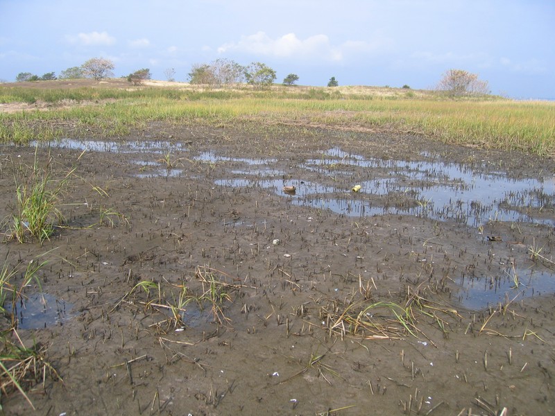
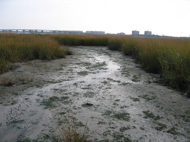
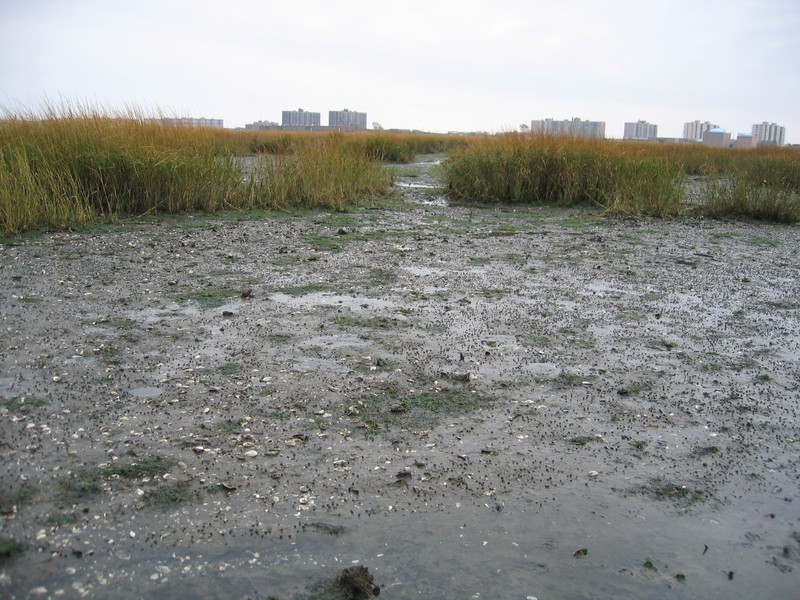
Marine Intertidal Mudflats
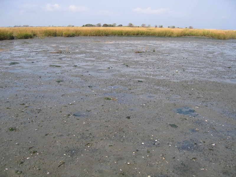
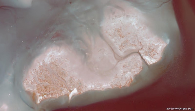
Marine intertidal mudflats in Jamaica Bay, Gateway National Recreation Area.
Gregory J. Edinger
- System
- Marine
- Subsystem
- Marine Intertidal
- State Protection
- Not Listed
Not listed or protected by New York State.
- Federal Protection
- Not Listed
- State Conservation Status Rank
- S2S3
Imperiled or Vulnerable in New York - Very vulnerable, or vulnerable, to disappearing from New York, due to rarity or other factors; typically 6 to 80 populations or locations in New York, few individuals, restricted range, few remaining acres (or miles of stream), and/or recent and widespread declines. More information is needed to assign either S2 or S3.
- Global Conservation Status Rank
- G5
Secure globally - Common in the world; widespread and abundant (but may be rare in some parts of its range).
Summary
Did you know?
Walking on mudflats can be challenging and in some cases even dangerous. It is very easy to sink up to your waist in the soft mud, unless you wear "mudders." Mudder shoes have expandable wings on the side to provide support when crossing mudflats. Worn over boots or waders, the wings expand as you step onto soft surfaces to increase boot area by four times and then retract when you lift your foot.
State Ranking Justification
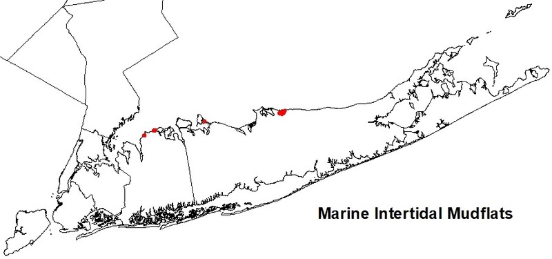
There are over 100 extant occurences of marine intertidal mudflats estimated statewide with 50-100 occurrences with good viability. They can be found across Long Island in north and south shore embayments and in the Peconic estuary at the eastern end of the island, as well as around New York City. The current trend of the community is likely declining; the speed and severity of the decline varies by site. Substantial primary threats include ditching and draining, dredging and filling, shoreline hardening, poor water quality, diking and impoundment, inlet stabilization, altered sediment budget, slumping and subsidence, changes in water circulation patterns, sea level rise, restricted tidal connection, and altered tidal hydrodynamics.
Short-term Trends
Over the last several decades, there have been significant decreases in the area of extent, number, and ecological integrity of low salt marshes in New York. Marine intertidal mudflats, which are adjacent to these marshes, may have suffered equally drastic declines, particularly from direct dredging and filling for urban development and maintaining navigation channels. Sea level rise may result in permanent flooding of some occurrences.
Long-term Trends
The number, aerial extent, and integrity of marine intertidal mudflats in New York are suspected to have declined substantially from their historical state. These declines are likely correlated with coastal development; dredging, ditching, and filling; and changes in hydrology, water quality, and natural processes.
Conservation and Management
Conservation Overview
Remove shoreline armoring to increase overland sediment input; improve water quality by reducing or eliminating sewer and stormwater discharge and pesticide application; restore tidal regime by removing culverts, dikes, and impoundments, plugging ditches, and replacing static flow restriction devices with those that are calibrated for local tidal hydrology. Ensure connectivity between the open saltwater and low salt marsh.
Threats
Factors that threaten salt marsh complexes also threaten marine intertidal mudflat communities. These include dredging and filling for development, ditching and draining for mosquito control, Poor water quality (from sewage and stormwater discharge; nonpoint source runoff; landfill leachate; boat traffic; particulate aircraft, vehicular, and power plant emissions; jet fuel; ethylene glycol from aircraft deicing; and pesticides used in mosquito management), diking and impoundment, inlet stabilization, shoreline hardening, altered sediment budget (decreased sediment input), subsidence, changes in water circulation patterns because of changes in shoreline and benthic topography, restricted tidal connection, and altered tidal hydrodynamics resulting from changes to hydrology (including groundwater levels, overland flow, and in-channel volume) in the surrounding watershed, road construction, and urbanization. Sea level rise may result in permanent flooding of some occurrences.
Conservation Strategies and Management Practices
Remove shoreline armoring to increase overland sediment input; improve water quality by reducing or eliminating sewer and stormwater discharge and pesticide application; restore tidal regime by removing culverts, dikes, and impoundments, plugging ditches, and replacing static flow restriction devices with those that are calibrated for local tidal hydrology. Restoration and monitoring protocols are available (Niedowski 2000).
Development and Mitigation Considerations
Strive to minimize or eliminate hardened shorelines and maintain low-sloped shorelines within the tidal zone to increase overland sediment input. Maintain functional connectivity between the open ocean and bays with salt marsh complexes to enable full tidal flushing during each tidal cycle. For example, barriers such as railway causeways should have numerous culverts to allow sufficient hydrologic connectivity. If flow restriction devices are needed, those that are calibrated for local tidal hydrology can be used. Avoid dumping dredge spoil onto mudflats and low salt marshes. This community is best protected as part of a large salt marsh complex. Protected areas should encompass the full mosaic of low salt marsh, high salt marsh, marine intertidal mudflats, saltwater tidal creek, salt panne, and salt shrub communities to allow dynamic ecological processes (sedimentation, erosion, tidal flushing, and nutrient cycling) to continue. Connectivity to brackish and freshwater tidal communities, upland beaches and dunes, and to shallow offshore communities should be maintained. Connectivity between these habitats is important not only for nutrient flow and seed dispersal, but also for animals that move between them seasonally. Development of site conservation plans that identify wetland threats and their sources and provide management and protection recommendations would ensure their long-term viability.
Inventory Needs
Inventory needs are to continue to search for large marine intertidal mudflats in good condition (A- to AB-ranked), prioritizing mudflats that are associated within high quality salt marsh complexes. Surveys and documentation of additional occurrences are needed, as are data on rare and characteristic animals, especially benthic invertebrates.
Research Needs
Future research on marine intertidal mudflats should include monitoring community response to sea level rise, sediment starvation, and permanent flooding and studying nutrient exchange processes and relationships to adjacent marine and estuarine communities.
Rare Species
Range
New York State Distribution
Marine intertidal mudflats are often adjacent to low salt marshes and saltwater tidal creeks. These communities have a similar distribution in the state and are restricted to sheltered areas of the seacoast in the the Coastal Lowlands and Manhattan Hills ecozones in Bronx, Westchester, Kings, Queens, Nassau, and Suffolk counties. Marine intertidal mudflats can be found across Long Island in north and south shore embayments and in the Peconic estuary at the eastern end of the island, as well as around New York City, in Westchester County on Long Island Sound, and in the Hudson River north to approximately the Tappan Zee Bridge.
Global Distribution
These intertidal mudflats extend along the Atlantic Coast, especially in the back-barrier bays, from Maine to New York and New Jersey.
Best Places to See
- Gateway National Recreation Area (Queens County)
- Great South Bay (Nassau, Suffolk Counties)
Identification Comments
General Description
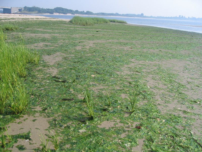
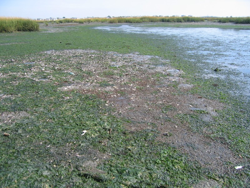
The marine intertidal mudflats community is located in quiet waters, with substrates composed of silt or sand that is rich in organic matter and poorly drained at low tide. This community is almost completely unvegetated. Cordgrass (Spartina alterniflora) can occur sporadically, colonizing from adjacent low salt marsh communities. The marine alga sea lettuce (Ulva lactuca) can cover 40% or more of the exposed substrate.
Characters Most Useful for Identification
This intertidal community is almost completely unvegetated on exposed mudflats adjacent to low salt marshes and saltwater tidal creeks where the salinity is greater than 18 ppt. This community is submerged during high tide, and exposed at low tide.
Elevation Range
Known examples of this community have been found at elevations between -1 feet and 9 feet.
Best Time to See
Marine intertidal mudflats are viewable year round, but are best viewed at low tide from a distance on firm ground or a boat.
Marine Intertidal Mudflats Images
Gregory J. Edinger
Gregory J. Edinger
Gregory J. Edinger
Gregory J. Edinger
NYS Orthoimagery from Spring 2010. Color Infrared.
Gregory J. Edinger
Gregory J. Edinger
Classification
International Vegetation Classification Associations
This New York natural community encompasses all or part of the concept of the following International Vegetation Classification (IVC) natural community associations. These are often described at finer resolution than New York's natural communities. The IVC is developed and maintained by NatureServe.
- Intertidal Mudflats Sparse Vegetation (CEGL006614)
Characteristic Species
-
Herbs
- Spartina alterniflora (smooth cord grass)
-
Nonvascular plants
- sea lettuce (Ulva lactuca)
-
Unvegetated
- American oystercatcher (Haematopus palliatus)
- blue mussel (Mytilus edulis)
- mudsnail (Ilyanassa obsoleta)
- polychaete (Heteromastus filiformis)
- polychaete (Lumbrinereis tenuis)
- polychaete (Nereis virens)
- polychaete (Polydora ligni)
- polychaete (Streblospio benedicti)
- softshell clam (Mya arenaria)
- willet (Catoptrophorus semipalmatus)
Similar Ecological Communities
- Low salt marsh
(guide)
Low salt marshes and marine intertidal mudflats are often adjacent to each other, or can form a patchy mosaic within an embayment. Both communities are influenced by diurnal tides and often have similar muddy substrates. However, marine intertidal mudflats are almost completely unvegetated compared to low salt marshes that have diverse and often dense vegetation cover dominated by cordgrass (Spartina alterniflora).
- Marine intertidal gravel/sand beach
(guide)
Both communities are intertidal and essentially unvegetated. However, marine intertidal mudflat substrates are composed of silt or sand that is rich in organic matter and poorly drained at low tide. Mudflats are usually adjacent to low salt marshes and saltwater tidal creeks. Whereas, marine intertidal gravel/sand beaches are composed of sand or gravel substrates that are well-drained at low tide; and they are usually adjacent to maritime beaches.
- Marine rocky intertidal
(guide)
Unlike marine rocky intertidal communities, which have high-energy wave action and rocky substrates, marine intertidal mudflats are characterized by quiet waters and unconsolidated soils. Marine intertidal mudflats occur on fine silt or sand that is rich in organic material. They are exposed at low tide, and have a diverse array of invertebrates that provide important fuel for migrating and breeding shorebirds.
- Maritime beach
(guide)
Marine intertidal mudflat substrates are composed of silt or sand that is rich in organic matter and poorly drained at low tide. Mudflats are usually adjacent to low salt marshes and saltwater tidal creeks. Whereas, maritime beaches are terrestrial and are located above the high tide line. Maritime beaches are usually adjacent to marine intertidal gravel/sand beaches offshore and maritime dunes or bluffs landward.
- Saltwater tidal creek
(guide)
Saltwater tidal creeks and marine intertidal mudflats are often adjacent to each other within a salt marsh complex. Both communities are influenced by diurnal tides and often have similar muddy substrates. However, marine intertidal mudflats are submerged during high tide, and exposed at low tide, whereas saltwater tidal creeks have a permanently flooded subtidal channel.
Vegetation
Percent cover
This figure helps visualize the structure and "look" or "feel" of a typical Marine Intertidal Mudflats. Each bar represents the amount of "coverage" for all the species growing at that height. Because layers overlap (shrubs may grow under trees, for example), the shaded regions can add up to more than 100%.
Additional Resources
References
Brown, B. 1993. A classification system of marine and estuarine habitats in Maine: An ecosystem approach to habitats. Part 1: benthic habitats. First iteration. Maine Natural Areas Program. Department of Economic and Community Development. Augusta, ME.
Edinger, G. J., A. L. Feldmann, T. G. Howard, J. J. Schmid, E. Eastman, E. Largay, and L. A. Sneddon. 2008. Vegetation Classification and Mapping at Gateway National Recreation Area. Technical Report NPS/NER/NRTR—2008/107. National Park Service. Northeast Region. Philadelphia, PA.
Edinger, G. J., D. J. Evans, S. Gebauer, T. G. Howard, D. M. Hunt, and A. M. Olivero (editors). 2014. Ecological Communities of New York State. Second Edition. A revised and expanded edition of Carol Reschke’s Ecological Communities of New York State. New York Natural Heritage Program, New York State Department of Environmental Conservation, Albany, NY. https://www.nynhp.org/ecological-communities/
New York Natural Heritage Program. 2024. New York Natural Heritage Program Databases. Albany, NY.
Reschke, Carol. 1990. Ecological communities of New York State. New York Natural Heritage Program, New York State Department of Environmental Conservation. Latham, NY. 96 pp. plus xi.
Townes, H. K. Jr. 1939. Ecological studies on the Long Island marine invertebrates of importance as fish food or bait. In: A biological survey of the salt waters of Long Island, 1938. Suppl. to the 28th Annual Report, 1938. A joint survey with the US Bureau of Fisheries. NYS Conservation Dept., Albany, NY.
Whitlatch, R. B. 1982. The ecology of New England tidal flats: a community profile. US Fish and Wildlife Service, Biological Services Program, US Dept. of Interior, Washington, DC FWS/OBS-81/01. 125 pp.
Xu, C. and W. Liu. 2023. The spatiotemporal assessments for tidal flat erosion associated with urban expansion in the conterminous coastal United States from 1985 to 2015. The Science of the Total Environment 899 (2023) 165660.
Links
About This Guide
This guide was authored by: Gregory J. Edinger
Information for this guide was last updated on: December 12, 2023
Please cite this page as:
New York Natural Heritage Program. 2024.
Online Conservation Guide for
Marine intertidal mudflats.
Available from: https://guides.nynhp.org/marine-intertidal-mudflats/.
Accessed July 27, 2024.