Low Salt Marsh
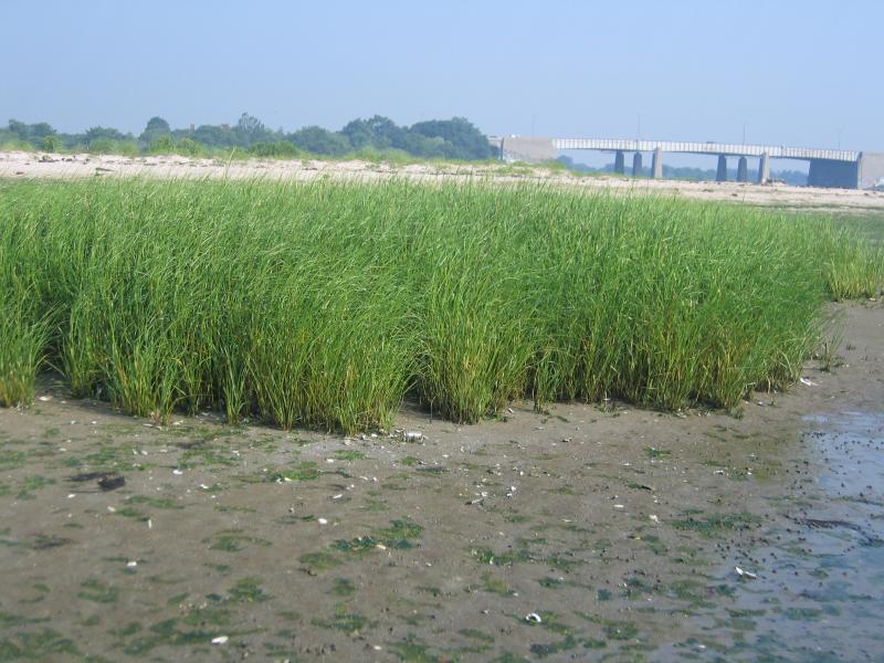
Low salt marsh in Jamaica Bay, Gateway National Recreation Area.
Gregory J. Edinger
- System
- Estuarine
- Subsystem
- Estuarine Intertidal
- State Protection
- Not Listed
Not listed or protected by New York State.
- Federal Protection
- Not Listed
- State Conservation Status Rank
- S1S2
Critically Imperiled or Imperiled in New York - Especially or very vulnerable to disappearing from New York due to rarity or other factors; typically 20 or fewer populations or locations in New York, very few individuals, very restricted range, few remaining acres (or miles of stream), and/or steep declines. More information is needed to assign either S1 or S2.
- Global Conservation Status Rank
- G4
Apparently Secure globally - Uncommon in the world but not rare; usually widespread, but may be rare in some parts of its range; possibly some cause for long-term concern due to declines or other factors.
Summary
Did you know?
The ribbed mussel (Geukensia demissa) is a common sight in low salt marshes; in Jamaica Bay marshes they can be found in clusters as dense as 10,000 mussels per square meter! This species can be distinguished from other mussels by the parallel grooves on their shells, which form annually and can be counted to determine the mussel's age. Ribbed mussels attach to the base of salt marsh cordgrass, to rocks in the muddy substrate, and to each other with silky 'byssus' protein threads that are secreted by a gland in the organism's foot. Individual mussels can live for more than 15 years and grow to over 10 cm in length (Franz 2000).
State Ranking Justification
There are an estimated 25 to 50 extant occurences statewide. The several documented occurrences have good viability and most are protected on public land or private conservation land. The community is restricted to sheltered areas of the seacoast in the the Coastal Lowlands and Manhattan Hills ecozones, and includes a few moderately sized, good quality examples. The current trend of the community is declining; the speed and severity of the decline varies by site. Substantial primary threats include ditching and draining, dredging and filling, shoreline hardening, poor water quality, diking and impoundment, inlet stabilization, altered sediment budget, slumping and subsidence, changes in water circulation patterns, sea level rise, restricted tidal connection, and altered tidal hydrodynamics.
Short-term Trends
Over the last several decades, there have been significant decreases in the area of extent, number, and ecological integrity of low salt marshes in New York. Several studies have reported significant losses of tidal wetlands in Jamaica Bay. From GNRA and JBWPPAC 2007: Tidal wetlands in Jamaica Bay are continuing to decrease at an accelerated rate. From 1951-1989, average marsh loss was 18 acres per year. From 1989-2003, average rate of loss was 33 acres per year. The Bay's marsh islands are projected to disappear between 2012 and 2024. From New York State Department of Environmental Conservation 2009b: "Between 1857-1924, intertidal marsh islands varied in size without trend, with average changes of up to 10 acres per year. During periods of significant storms, there were losses of marsh islands, but during quiescent years, the marsh islands were able to rebuild. From 1924-1974, 780 acres of marsh islands were lost due to direct dredging and filling (which were unregulated activities [until] 1974) and 510 acres were lost due to other reasons. Since 1974, the study shows that the rate of loss of intertidal marsh islands is accelerating. Between 1974-1994, 527 acres were lost at an average rate of 26 acres per year. From 1994-1990, 220 acres were lost at an average rate of 44 acres per year." Low salt marsh acreage is also decreasing in 14 targeted wetlands on the north and south shores of Long Island and in the Peconic Bay. A trends analysis showed that the losses were significant in 13 of the 14 wetlands (New York State Department of Environmental Conservation 2009c). Low salt marsh acreage has increased between 1974 and 1998 in Shinnecock Bay (161 acres) and Moriches Bay (100 acres) as a result of "landward movement of the tidal wetlands boundary" (New York State Department of Environmental Conservation 2009a).
Long-term Trends
The number, aerial extent, and integrity of low salt marshes in New York are suspected to have declined substantially from their historical state. These declines are likely correlated with coastal development; dredging, ditching, and filling; and changes in hydrology, water quality, and natural processes.
Conservation and Management
Threats
Historical and continuing threats and disturbances include: ditching and draining for mosquito control (which essentially converts low salt marsh into saltwater tidal creek), dredging and filling for navigation and development, shoreline hardening, poor water quality (from sewage and stormwater discharge, nonpoint source runoff, landfill leachate, boat traffic, particulate aircraft and vehicular emissions, jet fuel, ethylene glycol from aircraft deicing, and pesticides used in mosquito management), diking and impoundment, inlet stabilization, altered sediment budget (decreased sediment input to marshes), slumping and subsidence, changes in water circulation patterns because of changes in shoreline and benthic topography, restricted tidal connection and altered tidal hydrodynamics resulting from changes to hydrology (including groundwater levels, overland flow, and in-channel volume) in the surrounding watershed, road construction, geese overgrazing, mussel dams, common reed (Phragmites australis) invasion of brackish portions of the marshes, and wrack accumulation. Sea level rise may cause more frequent marsh inundation, erosion, and transformation to mudflats; however, adequate sediment inputs could prevent this scenario because increased sedimentation stimulates growth in cordgrass (Spartina alterniflora) (GNRA and JBWPPAC 2007, Niedowski 2000, New York State Department of Environmental Conservation 2009b, 2009c, 2009d).
Conservation Strategies and Management Practices
Remove shoreline armoring to increase overland sediment input; improve water quality by reducing or eliminating sewer and stormwater discharge and pesticide application; restore tidal regime by removing culverts, dikes, and impoundments, plugging ditches, and replacing static flow restriction devices with those that are calibrated for local tidal hydrology. Restoration and monitoring protocols are available (Niedowski 2000). Ensure connectivity between the open ocean, low salt marsh, and upland maritime dunes to allow species, such as the diamondback terrapin and the horseshoe crab, to freely move between habitats during nesting season.
Development and Mitigation Considerations
Strive to minimize or eliminate hardened shorelines and maintain low-sloped shorelines within the tidal zone to increase overland sediment input. Maintain functional connectivity between the open ocean and bays with salt marsh complexes to enable full tidal flushing during each tidal cycle. For example, barriers such as railway causeways should have numerous culverts to allow sufficient hydrologic connectivity. If flow restriction devices are needed, those that are calibrated for local tidal hydrology can be used. Avoid dumping dredge spoil onto low salt marshes. This community is best protected as part of a large salt marsh complex. Protected areas should encompass the full mosaic of low salt marsh, high salt marsh, marine intertidal mudflats, saltwater tidal creek, salt panne, and salt shrub communities to allow dynamic ecological processes (sedimentation, erosion, tidal flushing, and nutrient cycling) to continue. Connectivity to brackish and freshwater tidal communities, upland beaches and dunes, and to shallow offshore communities should be maintained. Connectivity between these habitats is important not only for nutrient flow and seed dispersal, but also for animals that move between them seasonally. Development of site conservation plans that identify wetland threats and their sources and provide management and protection recommendations would ensure their long-term viability.
Inventory Needs
Additional inventory is needed on the north and south shore of Long Island, in Peconic Bay, and in Gardiners Bay. Leads include sites that were not selected as reference wetlands by MacDonald and Edinger (2000). Sites on the north shore include Flax Pond, Long Beach Marsh (Stony Brook Harbor), Oak Neck Creek Marsh, and Mt. Sinai Harbor Marsh. South shore sites include Fire Island Wilderness, Gilgo Beach Back Barrier Marsh, Apple Tree Neck Wetlands, and Floyd Point Marsh. Sites in the Peconic Bay are Cow Neck Marsh, Bass Creek Marsh, Miss Annies Creek Marsh, Orient Point Marsh, Little Northwest Creek, Mashomack Point Marsh, Napeague Meadows, Downs Creek, and West Creek.
Research Needs
Continued research rangewide on causes of salt marsh decline and the synergism among them is needed. Continuing low salt marsh restoration and monitoring is needed. Future research of low salt marsh should include sampling of smaller marsh examples and investigating their connection with shallow water marine systems, such as marine eelgrass and algae beds. Eelgrass appears to play an important role in nutrient import and export, especially in the Great South Bay. In addition, there is a need for more study of the faunal diversity of nearby tidal creeks and near shore shallow zones in connection with the associated salt marshes. Strong regional differences are suspected (MacDonald and Edinger 2000).
Rare Species
- Ammodramus maritimus (Seaside Sparrow) (guide)
- Ardea alba (Great Egret) (guide)
- Asio flammeus (Short-eared Owl) (guide)
- Atriplex dioica (Thick-leaved Orach) (guide)
- Bubulcus ibis (Cattle Egret) (guide)
- Charadrius melodus (Piping Plover) (guide)
- Chenopodium berlandieri var. macrocalycium (Large-calyxed Goosefoot) (guide)
- Circus hudsonius (Northern Harrier) (guide)
- Egretta caerulea (Little Blue Heron) (guide)
- Egretta thula (Snowy Egret) (guide)
- Egretta tricolor (Tricolored Heron) (guide)
- Eleocharis uniglumis (Single-glumed Spike Rush) (guide)
- Gelochelidon nilotica (Gull-billed Tern) (guide)
- Kinosternon subrubrum (Eastern Mud Turtle) (guide)
- Leucophaeus atricilla (Laughing Gull) (guide)
- Lilaeopsis chinensis (Eastern Grasswort) (guide)
- Nyctanassa violacea (Yellow-crowned Night-Heron) (guide)
- Plegadis falcinellus (Glossy Ibis) (guide)
- Rumex fueginus (American Golden Dock) (guide)
- Rynchops niger (Black Skimmer) (guide)
- Sterna dougallii (Roseate Tern) (guide)
- Sterna forsteri (Forster's Tern) (guide)
- Sterna hirundo (Common Tern) (guide)
- Tripsacum dactyloides (Northern Gama Grass) (guide)
- Tyto alba (Barn Owl) (guide)
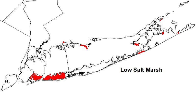
Range
New York State Distribution
Low salt marsh is restricted to sheltered areas of the seacoast in the the Coastal Lowlands and Manhattan Hills ecozones in Bronx, Westchester, Kings, Queens, Nassau, and Suffolk counties. It can be found across Long Island in north and south shore embayments and in the Peconic estuary at the eastern end of the island, as well as around New York City, in Westchester County on Long Island Sound, and in the Hudson River north to approximately the Tappan Zee Bridge (Niedowski 2000). It is well-developed in the south shore micro-tidal area and the small basins of the north shore meso-tidal area, where it is the dominant community type. It is also well-developed within the backbarrier fringe marshes and mid-lagoon marshes of Shinnecock Bay (MacDonald and Edinger 2000).
Global Distribution
This community occurs along the Atlantic coastline from Nova Scotia and New Brunswick south to Cape Hatteras, North Carolina (NatureServe 2009).
Best Places to See
- Gateway National Recreation Area (Queens County)
- Jones Beach State Park (Nassau County)
Identification Comments
General Description
A coastal marsh community that occurs in sheltered areas of the seacoast, in a zone extending from mean high tide down to mean sea level or to about 2 m (6 ft) below mean high tide. It is regularly flooded by semidiurnal tides. The mean tidal range of low salt marshes on Long Island is about 80 cm, and they often form in basins with a depth of 1.6 m or greater. The low salt marsh is one zone within a coastal salt marsh ecosystem; it occurs in a mosaic with several other communities. Low salt marsh grades into high salt marsh at slightly higher elevations, and into intertidal mudflats at slightly lower elevations. Saltwater tidal creeks that drain the salt marsh flow in a sinuous pattern through the marsh, with a narrow band of low marsh lining the banks of the saltwater tidal creeks. Shallow depressions, or pannes, may also occur in the low marsh.
Characters Most Useful for Identification
The vegetation of the low salt marsh is a nearly monospecific stand of cordgrass (Spartina alterniflora), a coarse grass that grows up to about 3 m (10 ft) tall. Salt marshes with large tidal ranges are often dominated by the tall form of Spartina alterniflora, while those with more restricted tidal ranges will be limited to a short form Spartina alterniflora zone that grades into high salt marsh (Niedowski 2000). A few species of marine algae can form dense mats on the surface sediments between the cordgrass stems, including knotted wrack (Ascophyllum nodosum) and rockweed (Fucus vesiculosus); sea lettuce (Ulva spp.) and hollow green weeds (Enteromorpha spp.) can be abundant, especially in early summer. Other plants that are present in very low numbers include glassworts (Salicornia depressa, S. bigelovii), salt marsh sand-spurry (Spergularia marina), and sea blites (Suaeda spp.). Several birds that nest in salt marshes include marsh wren (Cistothorus palustris), saltmarsh sharp-tailed sparrow (Ammodramus caudacutus), red-winged blackbird (Agelaius phoeniceus), black-crowned night heron (Nycticorax nycticorax), Canada goose (Branta canadensis), American black duck (Anas rubripes), and sometimes clapper rail (Rallus longirostris) and willet (Catoptrophorus semipalmatus) (Niedowski 2000). Many more birds depend on salt marshes for food, such as green heron (Butorides striatus), great egret (Casmerodius albus), snowy egret (Egretta thula), glossy ibis (Plegadis falcinellus), tree swallow (Tachycineta bicolor), and terns (Sterna spp.) (Niedowski 2000). Other characteristic salt marsh fauna include fiddler crabs (Uca pugilator and U. pugnax) nesting along creek banks, ribbed mussel (Geukensia dimissa), and at high tide mummichog (Fundulus heteroclitus), and several other small fishes that live in the tidal creeks at low tide.
Best Time to See
By midsummer, these cordgrass meadows are in full bloom. The marsh can be explored on foot twice daily at low tide; this is the best time to examine the network of fibrous roots and peat that holds the marsh together, to observe associated invertebrate species such as ribbed mussels and the eastern mud snail, and to see shorebirds feeding on sea lettuce.
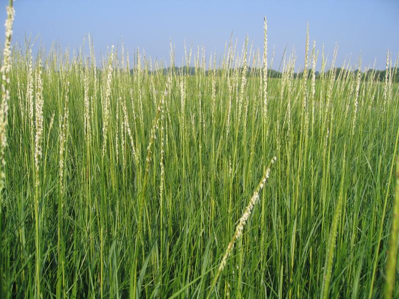
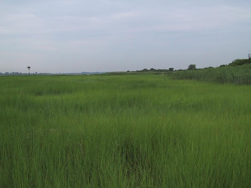
Low Salt Marsh Images
Gregory J. Edinger
Gregory J. Edinger
Aissa L. Feldmann
Classification
International Vegetation Classification Associations
This New York natural community encompasses all or part of the concept of the following International Vegetation Classification (IVC) natural community associations. These are often described at finer resolution than New York's natural communities. The IVC is developed and maintained by NatureServe.
- Smooth Cordgrass North Atlantic Salt Marsh (CEGL004192)
NatureServe Ecological Systems
This New York natural community falls into the following ecological system(s). Ecological systems are often described at a coarser resolution than New York's natural communities and tend to represent clusters of associations found in similar environments. The ecological systems project is developed and maintained by NatureServe.
- Northern Atlantic Coastal Plain Tidal Salt Marsh (CES203.519)
Characteristic Species
-
Herbs
- Distichlis spicata (salt grass)
- Limonium carolinianum (sea-lavender)
- Solidago sempervirens (northern seaside goldenrod)
- Spartina alterniflora (smooth cord grass)
- Spartina patens (salt-meadow cord grass)
- Suaeda maritima
Similar Ecological Communities
- High salt marsh
(guide)
High marsh vegetation is only periodically flooded by spring and flood tides and occurs in a mosaic, with patches that are dominated by salt-meadow grass, spikegrass, or a dwarf form (15 to 30 cm tall) of cordgrass. Low salt marsh is characterized by a near monoculture of cordgrass located at slightly lower elevation than high salt marsh.
- Marine intertidal mudflats
(guide)
Low salt marshes and marine intertidal mudflats are often adjacent to each other, or can form a patchy mosaic within an embayment. Both communities are influenced by diurnal tides and often have similar muddy substrates. However, marine intertidal mudflats are almost completely unvegetated compared to low salt marshes that have diverse and often dense vegetation cover dominated by cordgrass (Spartina alterniflora).
- Saltwater tidal creek
(guide)
Saltwater tidal creeks meander through low salt marshes. Low salt marshes, like saltwater tidal creeks, are influenced by diurnal tides, but salt marshes are not flowing channels, and have diverse and often dense vegetation cover dominated by cordgrass (Spartina alterniflora).
Vegetation
Percent cover
This figure helps visualize the structure and "look" or "feel" of a typical Low Salt Marsh. Each bar represents the amount of "coverage" for all the species growing at that height. Because layers overlap (shrubs may grow under trees, for example), the shaded regions can add up to more than 100%.
Additional Resources
References
Clark, J.S. 1985. The development of a tidal marsh: upland and oceanic influences. Ecol. Monogr. 55(2): 189-217.
Clark, J.S. 1986. Dynamism in the barrier-beach vegetation of Great South Beach, New York. Ecological Monographs 56(2):97-126.
Conard, H.S. 1935. The plant associations of central Long Island. American Midland Naturalist 16:433-515.
Dreyer, G.D. and W.A. Niering. 1995. Tidal marshes of Long Island Sound: ecology, history, and restoration. The Connecticut College Arboretum. Bulletin no. 34. 72 p.
Edinger, G. J., D. J. Evans, S. Gebauer, T. G. Howard, D. M. Hunt, and A. M. Olivero (editors). 2014. Ecological Communities of New York State. Second Edition. A revised and expanded edition of Carol Reschke’s Ecological Communities of New York State. New York Natural Heritage Program, New York State Department of Environmental Conservation, Albany, NY. https://www.nynhp.org/ecological-communities/
Edinger, Gregory J., D.J. Evans, Shane Gebauer, Timothy G. Howard, David M. Hunt, and Adele M. Olivero (editors). 2002. Ecological Communities of New York State. Second Edition. A revised and expanded edition of Carol Reschke's Ecological Communities of New York State. (Draft for review). New York Natural Heritage Program, New York State Department of Environmental Conservation. Albany, NY. 136 pp.
Franz, David R. 2000. Ribbed Mussels (Geukensia demissa). Available http://academic.brooklyn.cuny.edu/biology/franz/biology25/MUSSELS.HTM. (Accessed on November 13, 2009.)
Gateway National Recreation Area and Jamaica Bay Watershed Protection Plan Advisory Committee. 2007. An update on the disappearing salt marshes of Jamaica Bay, New York. Prepared by Gateway National Recreation Area, National Park Service, U.S. Department of the Interior and Jamaica Bay Watershed Protection Plan Advisory Committee, August 2, 2007.
Houghton, R.A. and G.M. Woodwell. 1980. The Flax Pond ecosystem study: exchanges of CO2 between a salt marsh and the atmosphere. Ecology 61(6): 1434-1445.
Joneja, Danielle. 1981. Sedimentary dynamics of Fire Island, New York. MS thesis. University of Massachusetts. Amherst, MA.
Long Island Sound Habitat Restoration Initiative. 2003. Technical Support for Coastal Habitat Restoration. Long Island Sound Study, Stamford, CT.
MacDonald, Dana and Gregory Edinger. 2000. Identification of reference wetlands on Long Island, New York. Final report prepared for the Environmental Protection Agency, Wetland Grant CD992436-01. New York Natural Heritage Program, New York State Department of Environmental Conservation. Latham, NY. 106 pp. plus appendices.
NatureServe. 2009. NatureServe Explorer: An online encyclopedia of life [web application]. Version 7.1. NatureServe, Arlington, Virginia. Available http://www.natureserve.org/explorer. (Data last updated July 17, 2009)
New York Natural Heritage Program. 2024. New York Natural Heritage Program Databases. Albany, NY.
New York State Department of Environmental Conservation. 2009a. Tidal wetlands. Available http://www.dec.ny.gov/lands/4940.html. (Accessed: October 27, 2009)
New York State Department of Environmental Conservation. 2009b. Tidal wetland losses, Jamaica Bay, Queens County, NY.
New York State Department of Environmental Conservation. 2009c. Tidal wetland losses, Nassau and Suffolk Counties.
New York State Department of Environmental Conservation. 2009d. Tidal wetland losses, Strategy for Addressing Loss of Intertidal Marsh in the Marine District.
New York State Department of State, Division of Coastal Resources. 1999. South Shore Estuary Reserve Wetland Restoration Dataset, Albany, NY.
Niedowski, N.L. 2000. New York State salt marsh restoration and monitoring guidelines. Prepared for New York Department of State, Albany, NY, and New York Department of Environmental Conservation, East Setauket, NY.
Nixon, S.W. 1982. The ecology of New England high salt marshes: A community profile. U.S. Fish and Wildlife Service Office of Biological Services, Washington D.C. FWS/OBS-81/55. 70 pp.
Packham, J.R. and A.J. Willis. 1997. Ecology of Dunes, Salt Marsh and Shingle. Chapman and Hall, London.
Redfield, A. C. 1972. Development of a New England salt marsh. Ecological Monographs 42:201-37.
Reschke, Carol. 1990. Ecological communities of New York State. New York Natural Heritage Program, New York State Department of Environmental Conservation. Latham, NY. 96 pp. plus xi.
Spinner, G.P. 1969. A plan for marine resources of the Atlantic coastal zone. Published in conjunction with Folio 18: The wildlife and shellfish areas of the Atlantic coastal zone. Serial atlas of the marine environment. American Geographical Society, NY.
Teal, J.M. 1986. The ecology of regularly flooded salt marshes of New England: a community profile. U.S. Fish and Wildlife Service, Biol. Rep. 85(7.4). 61 pp.
United States Army Corps of Engineers. 1996. Fire Island to Montauk Point Long Island, New York. Breach contingency plan. Unpublished report. January. 45 pp.
United States Army Corps of Engineers. 1999. Fire Island Inlet to Montauk Point, Long Island, New York. Reach 1. Fire Island Inlet. Draft decision document, an evaluation of an interim plan for storm damage protection. Volume 1. Main report and draft environmental impact statement. United States Army Corps of Engineers. New York District.
Links
About This Guide
This guide was authored by: Aissa Feldmann
Information for this guide was last updated on: December 12, 2023
Please cite this page as:
New York Natural Heritage Program. 2024.
Online Conservation Guide for
Low salt marsh.
Available from: https://guides.nynhp.org/low-salt-marsh/.
Accessed July 27, 2024.