Shale Talus Slope Woodland
Shale talus slope woodland
D.J. Evans
- System
- Terrestrial
- Subsystem
- Barrens And Woodlands
- State Protection
- Not Listed
Not listed or protected by New York State.
- Federal Protection
- Not Listed
- State Conservation Status Rank
- S3
Vulnerable in New York - Vulnerable to disappearing from New York due to rarity or other factors (but not currently imperiled); typically 21 to 80 populations or locations in New York, few individuals, restricted range, few remaining acres (or miles of stream), and/or recent and widespread declines.
- Global Conservation Status Rank
- G3G4
Vulnerable globally, or Apparently Secure - At moderate risk of extinction, with relatively few populations or locations in the world, few individuals, and/or restricted range; or uncommon but not rare globally; may be rare in some parts of its range; possibly some cause for long-term concern due to declines or other factors. More information is needed to assign either G3 or G4.
Summary
Did you know?
What is talus? Talus, or scree, is a steep slope usually found at the base of a mountain. The block size of the talus is strongly influenced by the type of rock forming the cliff face and the rate of erosion; for example, shale or rapidly eroding sandstone forms unstable, small, loose talus. The unstable nature of shale results in uneven slopes and many rock crevices. Other rocky types, such as hard dolostone caprock, produces stable, very large talus that provides habitat for much larger organisms.
State Ranking Justification
There are probably less than a couple hundred occurrences statewide. A few documented occurrences have good viability and few are protected on public land or private conservation land. This community is limited to regions of the state with shale bedrock/talus outcrops, and there are very few high quality examples. The current trend of this community is probably stable for occurrences on public land, or declining slightly elsewhere due to moderate threats that include development, trampling by visitors, and invasive species.
Short-term Trends
The number and acreage of shale talus slope woodlands in New York have probably declined slightly in recent decades as a result of development, trampling by visitors, and invasive species.
Long-term Trends
The number and acreage of shale talus slope woodlands in New York have probably declined moderately from historical numbers likely correlated with past development, trampling by visitors, and invasive species.
Conservation and Management
Threats
Threats to shale talus slope woodland are not well documented, but are presumed to be similar to those of shale cliff and talus communities. Both communities are threatened by development in the surrounding landscape (e.g., residential, agricultural). Other threats include habitat alteration (e.g., roads/parking areas, nearby logging & mining), and recreational overuse (e.g., trampling by visitors, ATVs, mountain bikes, campgrounds, picnic areas, swimming, rock/ice climbing, trash dumping). Threats to adjacent streams may apply to this community (e.g., alteration to hydrology, pollution, nutrient loading, impoundments/flooding, dredging). Several shale talus slope woodlands are threatened by invasive species, such as purple loosestrife (Lythrum salicaria), reed canary grass (Phalaris arundinacea), spotted knapweed (Centaurea maculosa), and colt's-foot (Tussilago farfara).
Conservation Strategies and Management Practices
Where practical, establish and maintain a natural forested buffer to reduce storm-water, pollution, and nutrient run-off, while simultaneously capturing sediments before they reach the shale talus slope woodlands. Avoid habitat alteration along the cliff and surrounding landscape. Restore past impacts. Prevent the spread of invasive exotic species into the woodland through appropriate direct management, and by minimizing potential dispersal corridors, such as roads and trails.
Development and Mitigation Considerations
A natural (usually forested) buffer around the edges of this community will help it maintain the micro-climatic characteristics that make it unique.
Inventory Needs
Survey and document more occurrences. Survey for occurrences statewide to advance documentation and classification of shale cliff and talus communities. Continue searching for large sites in good condition (A- to AB-ranked). Better document the threats to this community.
Research Needs
Research composition of shale talus slope woodlands statewide in order to characterize variations. Collect sufficient plot data to support the recognition of several distinct shale talus slope woodland types based on composition, specific geology, and by ecoregion.
Rare Species
Range
New York State Distribution
This community is scattered but widespread throughout upstate New York, north of the North Atlantic Coast Ecoregion and south of the Adirondack Mountains, where bedrock is shale. Shale bedrock is essentially limited to parts of the High Allegheny Plateau, Western Allegheny Plateau, Great Lakes and Lower New England Ecoregions.
Global Distribution
This community is currently described only from New York, it is also reported from New Jersey, Pennsylvania, and Vermont.
Best Places to See
- Frenchmans Bluff Preserve
- Catskill Park (Ulster County)
- Neversink River Preserve (Orange County)
Identification Comments
General Description
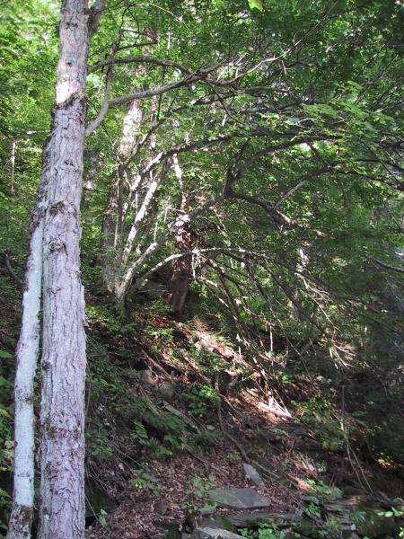
An open to closed canopy woodland that occurs on talus slopes composed of shale. These slopes are rather unstable, and they are usually very well-drained, so the soils are shallow and dry. The canopy cover is usually less than 50%, due to the instability of the substrate. Characteristic trees include chestnut oak, pignut hickory, red oak, and white oak. Characteristic shrubs and herbs include smooth sumac, scrub oak, penstemon, and Pennsylvania sedge.
Characters Most Useful for Identification
A woodland that occurs on shallow soils of talus slopes composed of shale. Oaks and hickories are characteristic trees.
Elevation Range
Known examples of this community have been found at elevations between 250 feet and 1,500 feet.
Best Time to See
Because the characteristic plants of shale talus slope woodlands are deciduous trees, it is easiest to identify the community during the growing season, from late May through summer. Striking seasonal leaf color can be enjoyed in the fall.
Shale Talus Slope Woodland Images
D.J. Evans
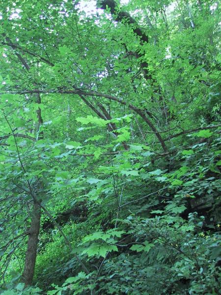
D.J. Evans
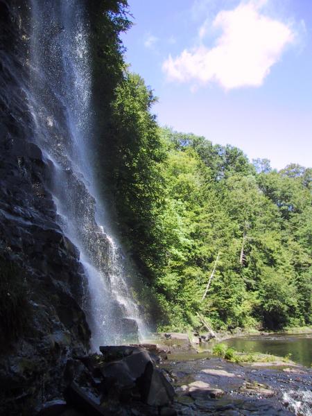
D.J. Evans
Classification
International Vegetation Classification Associations
This New York natural community encompasses all or part of the concept of the following International Vegetation Classification (IVC) natural community associations. These are often described at finer resolution than New York's natural communities. The IVC is developed and maintained by NatureServe.
- Chestnut Oak / Sumac species / Wavy Hairgrass Woodland (CEGL006074)
NatureServe Ecological Systems
This New York natural community falls into the following ecological system(s). Ecological systems are often described at a coarser resolution than New York's natural communities and tend to represent clusters of associations found in similar environments. The ecological systems project is developed and maintained by NatureServe.
- Central Appalachian Pine-Oak Rocky Woodland (CES202.600)
Characteristic Species
-
Trees > 5m
- Acer saccharum (sugar maple)
- Betula lenta (black birch)
- Carya glabra (pignut hickory)
- Ostrya virginiana (hop hornbeam, ironwood)
- Pinus strobus (white pine)
- Quercus rubra (northern red oak)
-
Shrubs 2 - 5m
- Acer pensylvanicum (striped maple)
- Staphylea trifolia (bladdernut)
-
Shrubs < 2m
- Cornus racemosa (gray dogwood, red-panicled dogwood)
-
Herbs
- Actaea pachypoda (white baneberry, doll's-eyes)
- Ageratina altissima var. altissima (common white snakeroot)
- Antennaria plantaginifolia (plantain-leaved pussy-toes)
- Carex pensylvanica (Pennsylvania sedge)
- Dryopteris marginalis (marginal wood fern)
- Eurybia divaricata (white wood-aster)
- Fragaria vesca ssp. americana (American woodland strawberry)
- Penstemon hirsutus (hairy beard-tongue)
- Polygonatum biflorum var. biflorum (small Solomon's-seal)
- Polystichum acrostichoides (Christmas fern)
- Solidago speciosa (showy goldenrod)
-
Nonvascular plants
- Moss
Similar Ecological Communities
- Acidic talus slope woodland
(guide)
While both communities have at least 25% cover trees on talus, shale talus slope woodlands occur on shale talus instead of the granite, quartzite, or schist talus of the acidic talus slope woodland.
- Calcareous talus slope woodland
(guide)
While both communities have at least 25% cover trees on talus, calcareous talus slope woodlands occur on calcareous rock such as limestone or dolomite, whereas shale talus slope woodlands occur on shale rock.
- Ice cave talus community
(guide)
Ice cave talus communities occur on rocks and soil at the base of talus slopes that emit cold air because winter ice remains deep within the talus. Vegetation of such communities is distinct because it includes species characteristic of climates much cooler than the climate of the area where the ice caves occur.
- Shale cliff and talus community
(guide)
While both communities occur on shale rock, shale cliff and talus communities tend to be steeper and usually sparsely vegetated, and typically have very few to no trees. Whereas, shale talus slope woodlands are not as steep and have at least 25% cover of trees.
Vegetation
Percent cover
This figure helps visualize the structure and "look" or "feel" of a typical Shale Talus Slope Woodland. Each bar represents the amount of "coverage" for all the species growing at that height. Because layers overlap (shrubs may grow under trees, for example), the shaded regions can add up to more than 100%.
Additional Resources
References
Edinger, G. J., D. J. Evans, S. Gebauer, T. G. Howard, D. M. Hunt, and A. M. Olivero (editors). 2014. Ecological Communities of New York State. Second Edition. A revised and expanded edition of Carol Reschke’s Ecological Communities of New York State. New York Natural Heritage Program, New York State Department of Environmental Conservation, Albany, NY. https://www.nynhp.org/ecological-communities/
Edinger, Gregory J., D.J. Evans, Shane Gebauer, Timothy G. Howard, David M. Hunt, and Adele M. Olivero (editors). 2002. Ecological Communities of New York State. Second Edition. A revised and expanded edition of Carol Reschke's Ecological Communities of New York State. (Draft for review). New York Natural Heritage Program, New York State Department of Environmental Conservation. Albany, NY. 136 pp.
McVaugh, R. 1958. Flora of the Columbia County area, New York. Bull. 360. New York State Museum and Science Service. University of the State of New York. Albany, NY. 400 pp.
New York Natural Heritage Program. 2024. New York Natural Heritage Program Databases. Albany, NY.
New York Natural Heritage Program. No date. Field forms database: Electronic field data storage and access for New York Heritage ecology, botany, and zoology. New York Natural Heritage Program, New York State Department of Environmental Conservation. Albany, NY.
Reschke, Carol. 1990. Ecological communities of New York State. New York Natural Heritage Program, New York State Department of Environmental Conservation. Latham, NY. 96 pp. plus xi.
Links
About This Guide
This guide was authored by: Aissa Feldmann
Information for this guide was last updated on: November 15, 2023
Please cite this page as:
New York Natural Heritage Program. 2024.
Online Conservation Guide for
Shale talus slope woodland.
Available from: https://guides.nynhp.org/shale-talus-slope-woodland/.
Accessed July 26, 2024.