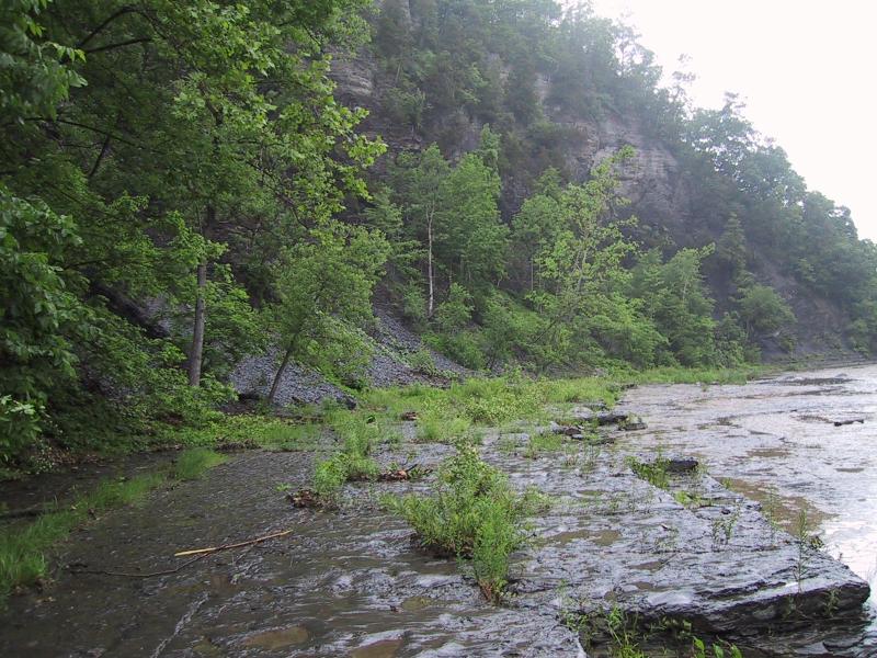
Calcareous Shoreline Outcrop

Stephen M. Young
- System
- Terrestrial
- Subsystem
- Open Uplands
- State Protection
- Not Listed
Not listed or protected by New York State.
- Federal Protection
- Not Listed
- State Conservation Status Rank
- S2
Imperiled in New York - Very vulnerable to disappearing from New York due to rarity or other factors; typically 6 to 20 populations or locations in New York, very few individuals, very restricted range, few remaining acres (or miles of stream), and/or steep declines.
- Global Conservation Status Rank
- G3G4
Vulnerable globally, or Apparently Secure - At moderate risk of extinction, with relatively few populations or locations in the world, few individuals, and/or restricted range; or uncommon but not rare globally; may be rare in some parts of its range; possibly some cause for long-term concern due to declines or other factors. More information is needed to assign either G3 or G4.
Summary
Did you know?
What is calcareous? Calcareous communities occur around outcrops of calcium-rich bedrock such as limestone, dolomite, and marble.
State Ranking Justification
There are several hundred occurrences statewide. Some documented occurrences have good viability and many are protected on public land or private conservation land. This community is limited to the calcareous regions of the state, and there are only a few high quality examples. The current trend of this community is probably stable for occurrences on public land, or declining slightly elsewhere due to moderate threats that include shoreline development, trampling by visitors, and invasive species.
Short-term Trends
The number and acreage of calcareous shoreline outcrops in New York have probably declined slightly in recent decades as a result of shoreline development, trampling by visitors, and invasive species.
Long-term Trends
The number and acreage of calcareous shoreline outcrops in New York have probably declined moderately from historical numbers likely correlated with past shoreline development, trampling by visitors, and invasive species.
Conservation and Management
Threats
Calcareous shoreline outcrops are threatened by development (e.g., residential, agricultural, industrial), either directly within the community or in the surrounding landscape. Structures built along the shoreline are a particular threat to this community (e.g., riprap, boat launches, cabins). Other threats include habitat alteration (e.g., road crossings, logging, mining), and relatively minor recreational overuse (e.g., boating, ATVs, trampling by visitors, campgrounds, picnic areas, fishing, trash dumping). Threats to the adjacent lake and river may apply to the shoreline outcrop (e.g., pollution, nutrient loading, sedimentation, impoundments/flooding, water release for rafting). Several calcareous shoreline outcrops are threatened by invasive species, such as purple loosestrife (Lythrum salicaria), reed canary grass (Phalaris arundinacea), reedgrass (Phragmites australis ssp. australis), Canada bluegrass (Poa compressa), multiflora rose (Rosa multiflora), colt's foot (Tussilago farfara), and buckthorn (Rhamnus cathartica).
Conservation Strategies and Management Practices
Where practical, establish and maintain a natural forested buffer to reduce storm-water, pollution, and nutrient run-off, while simultaneously capturing sediments before they reach the shoreline. Avoid habitat alteration along the shoreline and surrounding landscape. Restore calcareous shoreline outcrop communities that have been unnaturally disturbed (e.g., remove obsolete impoundments in order to restore the natural hydrology). Prevent the spread of invasive exotic species into the shoreline outcrop through appropriate direct management, and by minimizing potential dispersal corridors, such as roads and bridges.
Development and Mitigation Considerations
Where practical, establish and maintain a natural river/lake shore buffer (e.g., forest, woodland, shrubland) to filter storm-water, pollution, and nutrient run-off from surrounding uplands and to capture sediments before they reach the calcareous shoreline outcrop. Avoid habitat alteration along the shoreline and in surrounding landscape. Minimize potential dispersal corridors for exotic species, such as roads and bridges. Maintain or restore the natural flood and ice scour regime.
Inventory Needs
Survey for occurrences statewide to advance documentation and classification of calcareous shoreline outcrops. Continue searching for large sites in excellent to good condition (A- to AB-ranked).
Research Needs
Research composition of calcareous shoreline outcrops statewide in order to characterize variations (e.g., river vs. lake shorelines). Collect sufficient plot data to support the recognition of several distinct calcareous shoreline outcrop types based on composition, specific geology, and by ecoregion.
Rare Species
- Anticlea elegans var. glauca (White Death Camas) (guide)
- Boechera grahamii (Graham's Rock Cress) (guide)
- Calamagrostis stricta (Northern Reed Grass) (guide)
- Carex backii (Back's Sedge) (guide)
- Carex buxbaumii (Brown Bog Sedge) (guide)
- Carex capillaris (Hair-like Sedge) (guide)
- Carex crawei (Crawe's Sedge) (guide)
- Carex garberi (Elk Sedge) (guide)
- Carex sychnocephala (Many-headed Sedge) (guide)
- Conardia compacta (Coast creeping moss) (guide)
- Corydalis aurea (Golden Corydalis) (guide)
- Cypripedium arietinum (Ram's Head Lady's Slipper) (guide)
- Didymodon ferrugineus (Rusty Beard-moss) (guide)
- Draba arabisans (Rock Whitlow Grass) (guide)
- Draba glabella (Smooth Whitlow Grass) (guide)
- Erigeron hyssopifolius (Hyssop-leaved Fleabane) (guide)
- Gentianopsis virgata (Lesser Fringed Gentian) (guide)
- Halenia deflexa (Spurred Gentian) (guide)
- Lysimachia quadriflora (Linear-leaved Loosestrife) (guide)
- Myurella julacea (Small Mousetail Moss) (guide)
- Panicum flexile (Wiry Witch Grass) (guide)
- Platydictya jungermannioides (False Willow Moss) (guide)
- Polygonum douglasii (Douglas' Knotweed) (guide)
- Prunus pumila var. depressa (Dwarf Cherry) (guide)
- Pseudocalliergon turgescens (Curving Feather Moss) (guide)
- Thalictrum venulosum var. confine (Veiny Meadow-rue) (guide)
- Trichophorum clintonii (Clinton's Club Sedge) (guide)
- Viola nephrophylla (Northern Bog Violet) (guide)
Range
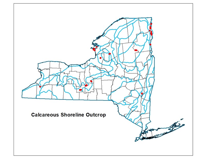
New York State Distribution
Found in the calcareous regions of the state including large portions of the Great Lakes region, and narrow river valleys and lakeshores in the High Alleghany Plateau, Northern Appalachians, and Lower New England Ecoregions. Shale variants are concentrated in the High Alleghany Plateau Ecoregion, especially the Finger Lakes region. Smaller, scattered examples of the shale community variant are known from the Tug Hill escarpment and the Lower New England Ecoregion.
Global Distribution
This physically broadly-defined community is likely to be widespread worldwide. Examples with the greatest biotic affinities to New York occurrences are suspected to span north to southern Canada, west to Minnesota, southwest to Indiana and Tennessee, southeast to Virginia, east to the Hudson Highlands of New York, and northeast to New Brunswick.
Best Places to See
- Adirondack Park
- El Dorado Beach Preserve (Jefferson County)
- Fillmore Glen State Park
- Hudson Gorge Primitive Area, Adirondack Park (Hamilton County)
- Watkins Glen State Park (Schuyler County)
- Henderson Shores Unique Area (Jefferson County)
Identification Comments
General Description
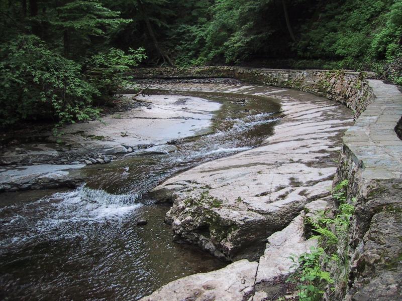
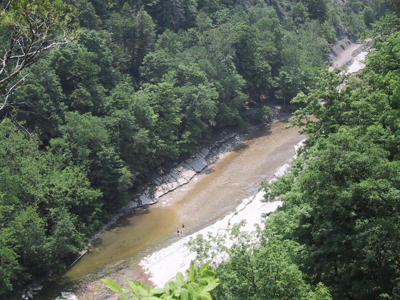
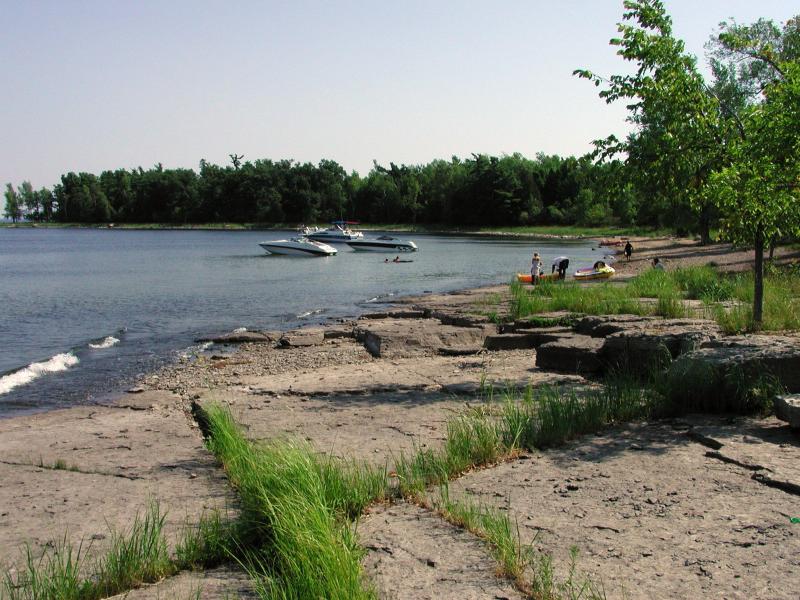
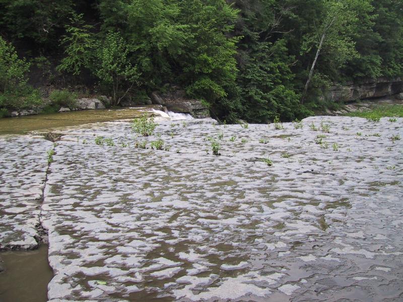
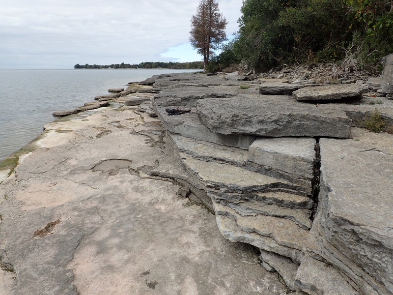
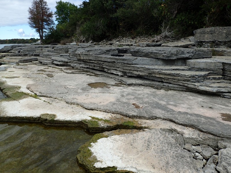
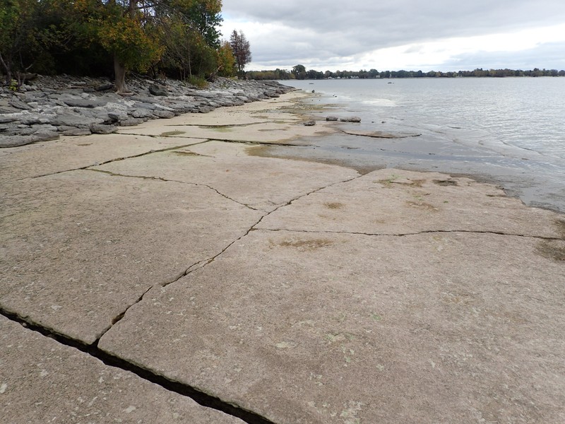
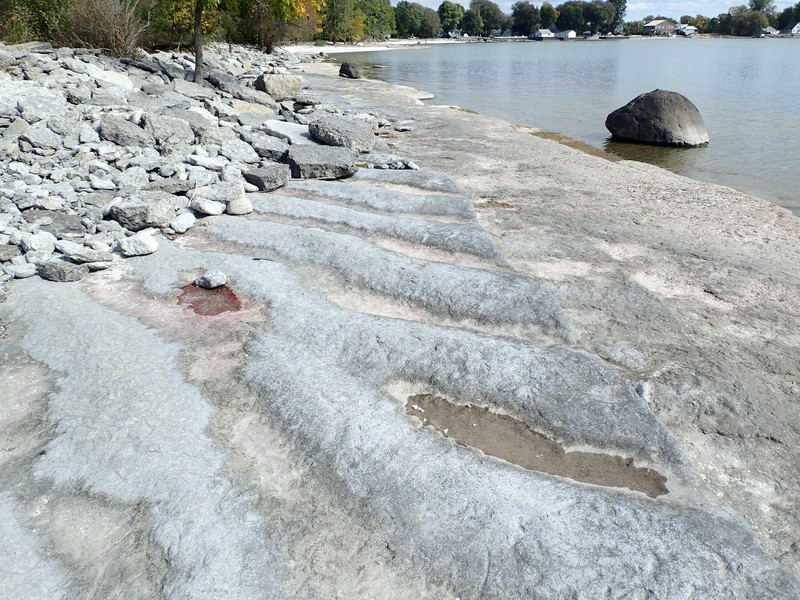
A community that occurs along the shores of lakes and streams on outcrops of calcareous rocks such as limestone and dolomite. The vegetation is sparse, as most of the plants plants are rooted in rock crevices. Mosses and lichens may be common on the rocks. Characteristic species include wild columbine (Aquilegia canadensis), sedges (Carex eburnea, C. granularis), silky dogwood (Cornus amomum), red osier dogwood (Cornus sericea), and meadow rue (Thalictrum spp.). Characteristic mosses include Tortella tortuosa and Tortula ruralis.
Characters Most Useful for Identification
Calcareous shoreline outcrops can be found along streams and lake shorelines in calcareous regions of the state. A shoreline or streambed environment consisting of exposed pavement bedrock and large slabs of sparsely vegetated limestone identify this community. Typical examples have pure calcareous bedrock: limestone, dolostone, calcite, or marble.
Elevation Range
Known examples of this community have been found at elevations between 20 feet and 1,600 feet.
Best Time to See
While this community can be identified anytime during the snow-free seasons, it is most enjoyable to visit during the growing season, from late May through summer, when plants are flowering and water temperatures are conducive to wading.
Calcareous Shoreline Outcrop Images
Stephen M. Young
Adele M. Olivero
Adele M. Olivero
Adele M. Olivero
Stephen M. Young
Adele M. Olivero
Gregory J. Edinger
Gregory J. Edinger
Gregory J. Edinger
Gregory J. Edinger
Classification
International Vegetation Classification Associations
This New York natural community encompasses all or part of the concept of the following International Vegetation Classification (IVC) natural community associations. These are often described at finer resolution than New York's natural communities. The IVC is developed and maintained by NatureServe.
- Bluebell Bellflower - Balsam Groundsel - (Red Columbine) Riverscour Sparse Vegetation (CEGL006532)
- Central Midwest-Interior Limestone - Dolostone Talus Vegetation (CEGL002308)
- Prairie Cordgrass - Mat Muhly - Prairie Dropseed - Prairie Goldenrod - Flat-top Goldentop Riverscour Sparse Vegetation (CEGL005233)
- Sticky Bog-asphodel - Elk Sedge Riverscour Wet Meadow (CEGL006142)
NatureServe Ecological Systems
This New York natural community falls into the following ecological system(s). Ecological systems are often described at a coarser resolution than New York's natural communities and tend to represent clusters of associations found in similar environments. The ecological systems project is developed and maintained by NatureServe.
- Boreal Ice-Scour Rivershore (CES103.589)
- Laurentian-Acadian Lakeshore Beach (CES201.586)
Characteristic Species
-
Shrubs 2 - 5m
- Thuja occidentalis (northern white cedar, arbor vitae)
-
Shrubs < 2m
- Cornus sericea (red-osier dogwood)
- Populus tremuloides (trembling aspen, quaking aspen)
-
Herbs
- Apocynum cannabinum (Indian-hemp)
- Aquilegia canadensis (wild columbine, red columbine)
- Bidens discoidea (few-bracted beggar-ticks)
- Carex eburnea (bristle-leaved sedge)
- Eupatorium serotinum (late thoroughwort)
- Taraxacum officinale (common dandelion)
-
Nonvascular plants
- Tortella tortuosa
Similar Ecological Communities
- Cobble shore
(guide)
Cobble shores also occur along the shores of lakes and streams, can also experience a significant amount of scouring, and can have vegetation that is very similar to calcareous shoreline outcrops (particularly in the calcareous regions of the state). Cobble shores are distinguished from calcareous shoreline outcrops by their very round rocks that have been well weathered by water action. The cobbles can be loose or embedded in sand, gravel, or peat, usually with vegetation rooted between them. Calcareous shoreline outcrops have large slabs of limestone, angular rocks, and exposed pavement bedrock.
- Riverside ice meadow
(guide)
Calcareous shoreline outcrops can occur as embedded features within riverside meadows and are very sparsely vegetated compared to ice meadows. Calcareous shoreline outcrops occur along the shores of lakes and streams on outcrops of calcareous rocks and are usually ice free at spring time in most years. Riverside ice meadows tend to have greater plant diversity compared to shoreline outrops.
- Riverside sand/gravel bar
(guide)
Calcareous shoreline outcrops are on calcareous rocks such as limestone and dolomite. Whereas, riverside sand/gravel bars are on unconsolidated sand and gravel.
- Shale cliff and talus community
(guide)
Calcareous shoreline outcrops are close enough to the waters of the lakes and streams they surround to experience significant amounts of wave and ice scouring, which distinguishes them from shale cliff and talus communities that occur on vertical exposures at slightly higher elevations.
- Shoreline outcrop
(guide)
Shoreline outcrops are on on outcrops of non-calcareous rocks such as anorthosite, granite, quartzite, sandstone, gneiss, or schist. Whereas calcareous shoreline outcrops are on calcareous rocks such as limestone and dolomite. Shoreline outcrop soil and bedrock pH should generally be 5.5 or less, while while the pH of calcareous shoreline outcrops are generally higher.
Vegetation
Percent cover
This figure helps visualize the structure and "look" or "feel" of a typical Calcareous Shoreline Outcrop. Each bar represents the amount of "coverage" for all the species growing at that height. Because layers overlap (shrubs may grow under trees, for example), the shaded regions can add up to more than 100%.
Additional Resources
References
Edinger, G. J., D. J. Evans, S. Gebauer, T. G. Howard, D. M. Hunt, and A. M. Olivero (editors). 2014. Ecological Communities of New York State. Second Edition. A revised and expanded edition of Carol Reschke’s Ecological Communities of New York State. New York Natural Heritage Program, New York State Department of Environmental Conservation, Albany, NY. https://www.nynhp.org/ecological-communities/
Edinger, Gregory J., D.J. Evans, Shane Gebauer, Timothy G. Howard, David M. Hunt, and Adele M. Olivero (editors). 2002. Ecological Communities of New York State. Second Edition. A revised and expanded edition of Carol Reschke's Ecological Communities of New York State. (Draft for review). New York Natural Heritage Program, New York State Department of Environmental Conservation. Albany, NY. 136 pp.
New York Natural Heritage Program. 2024. New York Natural Heritage Program Databases. Albany, NY.
Reschke, Carol. 1990. Ecological communities of New York State. New York Natural Heritage Program, New York State Department of Environmental Conservation. Latham, NY. 96 pp. plus xi.
About This Guide
Information for this guide was last updated on: December 13, 2023
Please cite this page as:
New York Natural Heritage Program. 2024.
Online Conservation Guide for
Calcareous shoreline outcrop.
Available from: https://guides.nynhp.org/calcareous-shoreline-outcrop/.
Accessed July 27, 2024.