Cobble Shore Wet Meadow
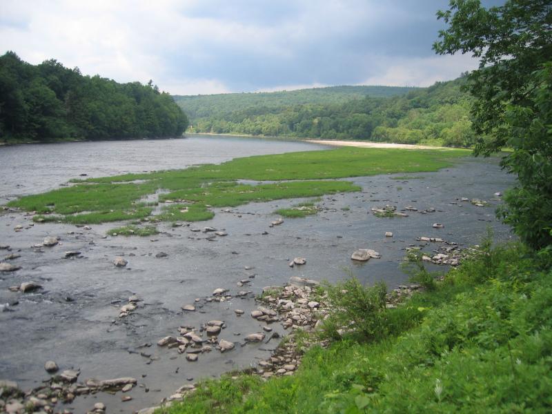
Water willow (Justicia americana) dominated cobble shore wet meadow in the Delaware River near Fish Cabin Creek.
Gregory J. Edinger
- System
- Palustrine
- Subsystem
- Open Mineral Soil Wetlands
- State Protection
- Not Listed
Not listed or protected by New York State.
- Federal Protection
- Not Listed
- State Conservation Status Rank
- S2
Imperiled in New York - Very vulnerable to disappearing from New York due to rarity or other factors; typically 6 to 20 populations or locations in New York, very few individuals, very restricted range, few remaining acres (or miles of stream), and/or steep declines.
- Global Conservation Status Rank
- G3?
Vulnerable globally (most likely) - Conservation status is uncertain, but most likely at moderate risk of extinction due to rarity or other factors; typically 80 or fewer populations or locations in the world, few individuals, restricted range, few remaining acres (or miles of stream), and/or recent and widespread declines. More information is needed to assign a firm conservation status.
Summary
Did you know?
A cobble is a rock or rock fragment with a particle size between 6 and 25 cm (2.5-10 inches) in diameter. Pebbles are the next smaller geologic size class; they range from 4 mm to 6 cm (<2.5 inches). Pieces of gravel range from 2 to 4 mm in size and particles of sand and silt are smaller still.
State Ranking Justification
There are probably only a few dozen occurrences statewide. A few documented occurrences have good viability and few are protected on public land or private conservation land. This community is limited to the water bodies with cobble shores that remain wet in the state, and there are only a few high quality examples. The current trend of this community is probably stable for occurrences on public land, or declining slightly elsewhere due to moderate threats that include alteration to hydrology, shoreline development, instream gravel mining, and invasive species.
Short-term Trends
The number and acreage of cobble shore wet meadows in New York have probably declined slightly in recent decades as a result of shoreline development, ateration to the hydrology, instream gravel mining, and invasive species.
Long-term Trends
The number and acreage of cobble shore wet meadows in New York have probably declined moderately from historical numbers likely correlated to the alteration of natural hydrology from impoundments, shoreline hardening, and instream gravel mining.
Conservation and Management
Threats
Cobble shore wet meadows are threatened by development (e.g., residential, agricultural, industrial) in the surrounding landscape. Structures built along the shoreline are a particular threat to this community (e.g., riprap, boat launches). Other threats include habitat alteration (e.g., instream gravel mining, road crossings, logging in adjacent floodplain), and relatively minor recreational overuse (e.g., boating, ATVs, trampling by visitors, fishing, trash dumping). Threats to adjacent lakes and rivers may apply to the cobble shore wet meadow (e.g., pollution, nutrient loading, sedimentation, impoundments/flooding, water release for rafting). Several cobble shore wet meadows are threatened by invasive species.
Conservation Strategies and Management Practices
Where practical, establish and maintain a natural wetland buffer to reduce storm-water, pollution, and nutrient run-off, while simultaneously capturing sediments before they reach the wetland. Buffer width should take into account the erodibility of the surrounding soils, slope steepness, and current land use. Wetlands protected under Article 24 are known as New York State "regulated" wetlands. The regulated area includes the wetlands themselves, as well as a protective buffer or "adjacent area" extending 100 feet landward of the wetland boundary (NYS DEC 1995). If possible, minimize the number and size of impervious surfaces in the surrounding landscape. Avoid habitat alteration within the wetland and surrounding landscape. For example, roads and trails should be routed around wetlands, and ideally not pass through the buffer area. If the wetland must be crossed, then bridges and boardwalks are preferred over filling. Restore past impacts, such as removing obsolete impoundments and ditches in order to restore the natural hydrology. Reduce or eliminate instream gravel mining from the best examples of cobble shore wet meadow. Prevent the spread of invasive exotic species into the wetland through appropriate direct management, and by minimizing potential dispersal corridors, such as roads. Maintain or restore the natural flood and ice scour regime.
Development and Mitigation Considerations
Where practical, establish and maintain a natural riparian buffer to filter storm-water, pollution, and nutrient run-off from surrounding uplands and to capture sediments before they reach the cobble shore. Avoid habitat alteration along the shoreline and in surrounding landscape. Minimize potential dispersal corridors for exotic species, such as roads and bridges. Maintain or restore the natural flood and ice scour regime.
Inventory Needs
Survey for occurrences statewide to advance documentation and classification of cobble shore wet meadow. Continue searching for large sites in good condition (A- to AB-ranked).
Research Needs
Research composition of cobble shore wet meadows statewide in order to characterize variations (e.g., river vs. lake shorelines) and to clearly separate from cobble shore and riverside sand/gravel bar. Collect sufficient plot data to support the recognition of several distinct cobble shore wet meadow types based on composition, cobble type, and by ecoregion.
Rare Species
- Anticlea elegans var. glauca (White Death Camas) (guide)
- Calamagrostis stricta (Northern Reed Grass) (guide)
- Carex capillaris (Hair-like Sedge) (guide)
- Carex emoryi (Emory's Sedge) (guide)
- Carex garberi (Elk Sedge) (guide)
- Carex sychnocephala (Many-headed Sedge) (guide)
- Cuscuta polygonorum (Smartweed Dodder) (guide)
- Isoetes riparia (Riverbank Quillwort) (guide)
- Prunus pumila var. depressa (Dwarf Cherry) (guide)
- Rotala ramosior (Toothcup) (guide)
- Spiranthes magnicamporum (Great Plains Ladies' Tresses) (guide)
- Thalictrum venulosum var. confine (Veiny Meadow-rue) (guide)
Range
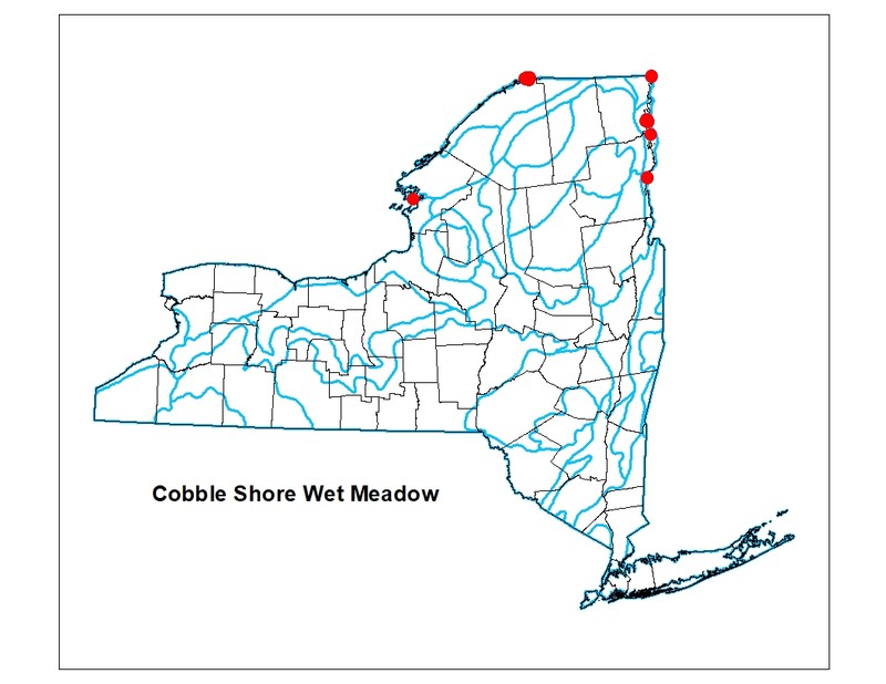
New York State Distribution
Currently mapped sites are restricted to Clinton County on the shores of Lake Champlain. It probably also occurs along Lake Ontario and the St. Lawrence River River, and possibly on a few large inland lakes (such as the Finger Lakes).
Global Distribution
This community is possibly restricted to the Great Lakes basin. Concentrated in the Saint Lawrence and Lake Champlain lowlands. It probably also occurs along the five Great Lakes and possibly on a few large inland lakes such as the Finger Lakes of New York. This range is estimated to span north to southern Ontario, west to Minnesota, south to Ohio and east to Vermont.
Best Places to See
- Adirondack Park
- Rouses Point Trailway
- Valcour Island Primitive Area
- Robert Moses State Park (St. Lawrence County)
Identification Comments
General Description
Cobble shore wet meadows occur on the cobble shorelines of lakes and rivers where the substrate is moist from seepage or intermittent flooding. The substrate is a mixture of cobbles, sand, and clay. These communities are likely to be scoured by floods or winter ice floes, but there is apparently no significant accumulation of pack ice. Vegetation may be sparse.
Characters Most Useful for Identification
Cobble shore wet meadows are dominated by cobbles at the soil surface and occur in linear patches along the shorelines of lakes and rivers. The patches must be close enough to an associated aquatic community to experience significant amounts of wave or ice scouring. Characteristic species include water plantain (Alisma plantago-aquatica), beggar-ticks (Bidens frondosa), spikerushes (Eleocharis spp.), common horsetail (Equisetum arvense), boneset (Eupatorium perfoliatum), silverweed (Potentilla anserina), creeping spearwort (Ranunculus reptans), and three square (Scirpus americanus). Water-willow (Justicia americana) is a characteristic plant of cobble shore wet meadows along rivers.
Elevation Range
Known examples of this community have been found at elevations between 84 feet and 250 feet.
Best Time to See
During late summer, when water levels are at their lowest, the greatest diversity of herbaceous plants can be observed. The exposed substrate along the water's edge can feature a large variety of forbs, sedges, and rushes.
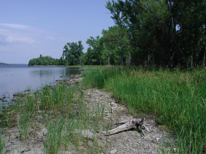
Cobble Shore Wet Meadow Images
Gregory J. Edinger
Stephen M. Young
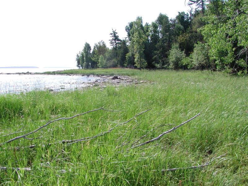
Stephen M. Young
Classification
International Vegetation Classification Associations
This New York natural community encompasses all or part of the concept of the following International Vegetation Classification (IVC) natural community associations. These are often described at finer resolution than New York's natural communities. The IVC is developed and maintained by NatureServe.
- American Water-willow Riverbed Vegetation (CEGL004286)
NatureServe Ecological Systems
This New York natural community falls into the following ecological system(s). Ecological systems are often described at a coarser resolution than New York's natural communities and tend to represent clusters of associations found in similar environments. The ecological systems project is developed and maintained by NatureServe.
- Central Appalachian River Floodplain (CES202.608)
- Central Appalachian Stream and Riparian (CES202.609)
Characteristic Species
-
Herbs
- Alisma subcordatum (southern water-plantain)
- Bidens frondosa (devil's beggar-ticks)
- Carex aurea (golden-fruited sedge)
- Carex flava (yellow sedge)
- Carex granularis (limestone-meadow sedge)
- Carex viridula
- Eleocharis spp.
- Equisetum arvense (field horsetail, common horsetail)
- Equisetum variegatum ssp. variegatum (Variegated scouring-rush)
- Eupatorium perfoliatum (boneset)
- Juncus alpinoarticulatus ssp. americanus (alpine rush)
- Juncus nodosus (knotted rush)
- Juncus pelocarpus (brown-fruited rush)
- Justicia americana (American water-willow)
- Lobelia kalmii (Kalm's lobelia)
- Potentilla anserina ssp. anserina (common silverweed)
- Ranunculus flammula var. reptans (narrow-leaved creeping spearwort)
- Schoenoplectus americanus (chair-maker's bulrush)
- Spartina pectinata (prairie cord grass)
- Thelypteris palustris var. pubescens (marsh fern)
-
Nonvascular plants
- Campylium stellatum
- Drepanocladus spp.
Similar Ecological Communities
- Cobble shore
(guide)
Cobble shores are sparsely to densely vegetated communities located along rivers and lakes, but they are considered terrestrial communities and are dominated by upland vegetation. The soil underlying cobble shore wet meadows is hydric and the vegetation is predominately hydrophytic.
- Inland calcareous lake shore
(guide)
Inland calcareous shoreline communities occur on the perimeters of calcareous lakes and have gravel, sand, or mud soils instead of cobbles, sand, and clay.
- Riverside ice meadow
(guide)
Riverside ice meadows occur on gently sloping cobble shore along large rivers and are scoured annually by ice, but they are well-vegetated terrestrial communities dominated by upland vegetation. The soil underlying cobble shore wet meadows is hydric and the vegetation is predominately hydrophytic.
- Riverside sand/gravel bar
(guide)
Riverside sand/gravel bars are terrestrial communities that occurs on well-drained sand and gravel bars deposited within, or adjacent to, a river channel. Whereas, the soil underlying cobble shore wet meadows is hydric and the vegetation is predominately hydrophytic.
- Shallow emergent marsh
(guide)
While both communities may share similar wetland plants and may occur along the shores of lakes and streams, they can be distinguished by their substrate. Cobble shore wet meadows typically have cobblestones exposed at the surface compared to shallow emergent marshes that are underlain by mineral soil or deep muck without cobbles.
- Shoreline outcrop
(guide)
Shoreline outcrops are on bedrock outcrops of non-calcareous rocks such as anorthosite, granite, quartzite, sandstone, gneiss, or schist, and considered terrestrial communities. Whereas, cobble shore wet meadows are underlain by hydric soil, rather than bedrock, and the vegetation is predominately hydrophytic.
Vegetation
Percent cover
This figure helps visualize the structure and "look" or "feel" of a typical Cobble Shore Wet Meadow. Each bar represents the amount of "coverage" for all the species growing at that height. Because layers overlap (shrubs may grow under trees, for example), the shaded regions can add up to more than 100%.
Additional Resources
References
Cowardin, L.M., V. Carter, F.C. Golet, and E.T. La Roe. 1979. Classification of wetlands and deepwater habitats of the United States. U.S. Fish and Wildlife Service. Washington, D.C. 131 pp.
Edinger, G. J., D. J. Evans, S. Gebauer, T. G. Howard, D. M. Hunt, and A. M. Olivero (editors). 2014. Ecological Communities of New York State. Second Edition. A revised and expanded edition of Carol Reschke’s Ecological Communities of New York State. New York Natural Heritage Program, New York State Department of Environmental Conservation, Albany, NY. https://www.nynhp.org/ecological-communities/
Edinger, Gregory J., D.J. Evans, Shane Gebauer, Timothy G. Howard, David M. Hunt, and Adele M. Olivero (editors). 2002. Ecological Communities of New York State. Second Edition. A revised and expanded edition of Carol Reschke's Ecological Communities of New York State. (Draft for review). New York Natural Heritage Program, New York State Department of Environmental Conservation. Albany, NY. 136 pp.
New York Natural Heritage Program. 2024. New York Natural Heritage Program Databases. Albany, NY.
New York State Department of Environmental Conservation. 1995. Freshwater Wetlands: Delineation Manual. July 1995. New York State Department of Environmental Conservation. Division of Fish, Wildlife, and Marine Resources. Bureau of Habitat. Albany, NY.
Reschke, Carol. 1990. Ecological communities of New York State. New York Natural Heritage Program, New York State Department of Environmental Conservation. Latham, NY. 96 pp. plus xi.
Links
About This Guide
This guide was authored by: Shereen Brock
Information for this guide was last updated on: December 27, 2023
Please cite this page as:
New York Natural Heritage Program. 2024.
Online Conservation Guide for
Cobble shore wet meadow.
Available from: https://guides.nynhp.org/cobble-shore-wet-meadow/.
Accessed July 26, 2024.