Inland Salt Marsh
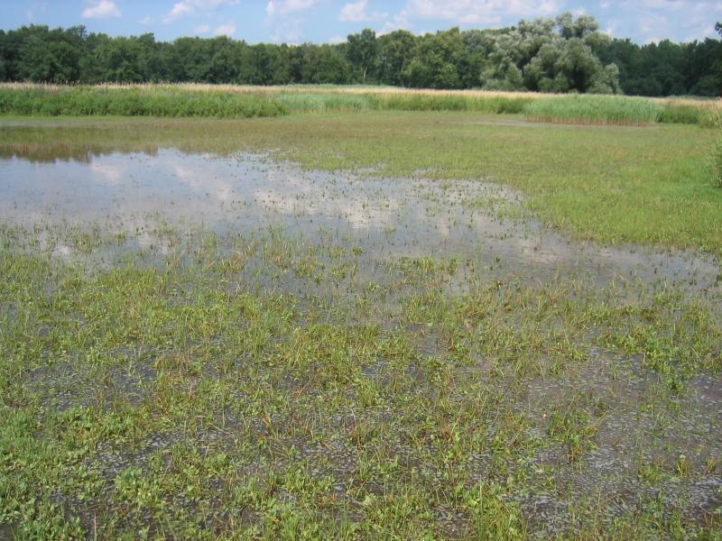
Inland salt marsh at Howland Island Wildlife Management Area.
Gregory J. Edinger
- System
- Palustrine
- Subsystem
- Open Peatlands
- State Protection
- Not Listed
Not listed or protected by New York State.
- Federal Protection
- Not Listed
- State Conservation Status Rank
- S1
Critically Imperiled in New York - Especially vulnerable to disappearing from New York due to extreme rarity or other factors; typically 5 or fewer populations or locations in New York, very few individuals, very restricted range, very few remaining acres (or miles of stream), and/or very steep declines.
- Global Conservation Status Rank
- G2
Imperiled globally - At high risk of extinction due to rarity or other factors; typically 20 or fewer populations or locations in the world, very few individuals, very restricted range, few remaining acres (or miles of stream), and/or steep declines.
Summary
Did you know?
The first area away from the ocean coasts in the United States where the substantial production of salt took place was the Onondaga Lake area in central New York state.
State Ranking Justification
This small patch community has been degraded or destroyed throughout its range. The largest examples were likely lost to activities related to salt mining and other industrial development. New York State is at the edge of the range of the community. There are less than five occurrences statewide, and probably not many more historically given that its range is primarily restricted to areas associated with inland salt springs in central New York. Although one documented occurrence has good viability, there are no high quality examples known in the state (i.e., no A- to AB-ranked occurrences). Only two inland salt marshes are protected on public land or private conservation land. The current trend of this community is declining moderately as a result of invasive species, agricultural and urban development, and alteration to the natural hydrology.
Short-term Trends
The number and acreage of inland salt marshes in New York have declined in recent decades as result of habitat destruction (e.g., filling of wetlands) and the spread of invasive species, such as common reed (Phragmites australis).
Long-term Trends
The number and acreage of inland salt marshes in New York have probably had a large decline (about 85%) from historical numbers likely correlated to the salt mining industry and other development.
Conservation and Management
Threats
Inland salt marshes are threatened by development and its associated run-off (e.g., agriculture, residential, commercial, roads), habitat alteration (e.g., pollution, dumping, utility ROWs), and recreational overuse (e.g., trampling, fishing?). Alteration to the natural hydrological regime is also a threat to this community (e.g., impoundments, ditching, beaver?). Inland salt marshes are threatened by invasive species, such as reed grass (Phragmites australis)and purple loosestrife (Lythrum salicaria).
Conservation Strategies and Management Practices
Where practical, establish and maintain a natural wetland buffer to reduce storm-water, pollution, and nutrient run-off, while simultaneously capturing sediments before they reach the wetland. Buffer width should take into account the erodibility of the surrounding soils, slope steepness, and current land use. Wetlands protected under Article 24 are known as New York State "regulated" wetlands. The regulated area includes the wetlands themselves, as well as a protective buffer or "adjacent area" extending 100 feet landward of the wetland boundary (NYS DEC 1995). If possible, minimize the number and size of impervious surfaces in the surrounding landscape. Avoid habitat alteration within the wetland and surrounding landscape. For example, roads and trails should be routed around wetlands, and ideally not pass through the buffer area. If the wetland must be crossed, then bridges and boardwalks are preferred over filling. Restore past impacts, such as removing obsolete impoundments and ditches in order to restore the natural hydrology. Prevent the spread of invasive exotic species into the wetland through appropriate direct management, and by minimizing potential dispersal corridors, such as roads.
Development and Mitigation Considerations
When considering road construction and other development activities, minimize actions that will change what water carries and how water travels to and from this community, both on the surface and underground. Water traveling over-the-ground as runoff usually carries an abundance of silt, clay, and other particulates during (and often after) a construction project. While still suspended in the water, these particulates make it difficult for aquatic animals to find food; after settling to the bottom of the system, they bury small plants and animals and alter the natural functions of the community in many other ways. Thus, road construction and development activities near this community type should strive to minimize particulate-laden run-off into this community. Water traveling on the ground or seeping through the ground also carries dissolved minerals and chemicals. Road salt, for example, is becoming an increasing problem both to natural communities and as a contaminant in household wells. Fertilizers, detergents, and other chemicals that increase the nutrient levels in wetlands cause algal blooms and eventually an oxygen-depleted environment in which few animals can live. Herbicides and pesticides often travel far from where they are applied and have lasting effects on the quality of the natural community. So, road construction and other development activities should strive to consider how water moves through the ground, the types of dissolved substances these development activities may release, and how to minimize the potential for these dissolved substances to reach this natural community.
Inventory Needs
Search for historical sites, possibly needs some de novo work.
Research Needs
There is a need for research focusing on identifying and compiling information on previously known and suspected locations of inland salt marshes. Research is also needed to understand both the historical range of variation in water level fluctuations from year to year and how the composition and abundance of the mud flats vegetation varies in conjunction with these fluctuations.
Rare Species
- Circus hudsonius (Northern Harrier) (guide)
- Cistothorus stellaris (Sedge Wren) (guide)
- Diplachne fusca ssp. fascicularis (Salt-meadow Grass) (guide)
- Rallus elegans (King Rail) (guide)
- Rumex fueginus (American Golden Dock) (guide)
- Sterna hirundo (Common Tern) (guide)
- Symphyotrichum subulatum var. subulatum (Annual Saltmarsh Aster) (guide)
Range
New York State Distribution
This community is restricted to the Great Lakes plain in Wayne, Seneca, Cayuga, and Onondaga counties. New York sites are at the eastern edge of range extending to Michigan and Indiana.
Global Distribution
This inland salt marsh community type is found in scattered locations in the upper midwestern United States in the Great Lakes region, including Illinois, Michigan, and central New York.
Best Places to See
- Carncross Salt Pond Preserve (Wayne County)
- Fox Ridge Salt Marsh
- Howland Island Wildlife Management Area (Wayne County)
Identification Comments
General Description
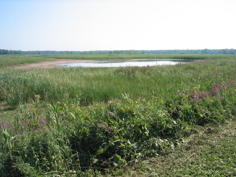
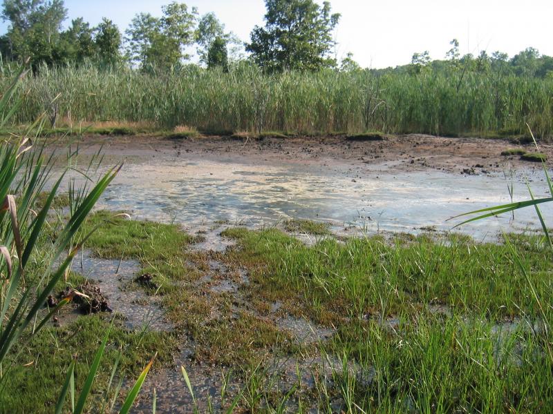
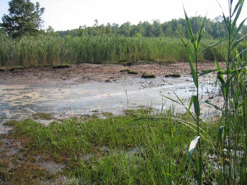
This herbaceous wetland community occurs on saline mudflats associated with inland salt springs. Within New York it is only known from the central portion of the state. The mucky substrate is permanently saturated and seasonally flooded. Vegetation ranges from 50-75% cover and sparse on exposed mudflats after drawdown.These salt springs are rare, and they usually occur as relatively small patches within deep or shallow emergent marshes.
Characters Most Useful for Identification
This inland, open marsh community of saline mudflats is associated with salt springs and characterized by salt-tolerant plants including lesser salt marsh sand-spurry (Spergularia marina), American saltmarsh bulrush (Bolbo-schoenus maritimus ssp. paludosus), narrow-leaved cattail (Typha angustifolia), spear orach (Atriplex patula), salt-meadow grass (Diplachne fusca ssp. fascicularis), creeping bent grass (Agrostis stolonifera), and dwarf spikerush (Eleocharis parvula). Other infrequently found plants with low percent cover include European alkali grass (Puccinellia distans), seaside buttercup (Ranunculus cymbalaria), chairmaker’s bulrush (Schoenoplectus americanus), widgeon grass (Ruppia maritima), black grass (Juncus gerardi), foxtail barley (Hordeum jubatum ssp. jubatum), barber-pole bulrush (Scirpus microcarpus). In some cases the surrounding marsh is dominated by purple loosestrife (Lythrum salicaria); since purple loosestrife is not very salt-tolerant, it usually does not grow in the inland salt marsh. However, the invasion of common reed (Phragmites australis) is a more serious threat to this community.
Elevation Range
Known examples of this community have been found at elevations between 370 feet and 380 feet.
Best Time to See
These marshes are most scenic during flush conditions in July and August, where any the surface water present is low in iron. At this time the characteristic flora is in full bloom, and these marshes are in their most aesthetically pleasing stage.
Inland Salt Marsh Images
Gregory J. Edinger
Gregory J. Edinger
Gregory J. Edinger

Gregory J. Edinger
Gregory J. Edinger

Classification
International Vegetation Classification Associations
This New York natural community encompasses all or part of the concept of the following International Vegetation Classification (IVC) natural community associations. These are often described at finer resolution than New York's natural communities. The IVC is developed and maintained by NatureServe.
- Cosmopolitan Bulrush - Spear Saltbush - Dwarf Spikerush Saline Marsh (CEGL005111)
NatureServe Ecological Systems
This New York natural community falls into the following ecological system(s). Ecological systems are often described at a coarser resolution than New York's natural communities and tend to represent clusters of associations found in similar environments. The ecological systems project is developed and maintained by NatureServe.
- Eastern Great Plains Wet Meadow, Prairie and Marsh (CES205.687)
Characteristic Species
-
Herbs
- Agrostis stolonifera (creeping bent)
- Atriplex patula (spear orach)
- Bolboschoenus maritimus ssp. paludosus (American salt marsh bulrush)
- Diplachne fusca ssp. fascicularis (bearded sprangle-top)
- Eleocharis parvula (salt-loving spike-rush)
- Hordeum jubatum ssp. jubatum (fox-tail barley, squirrel-tail barley)
- Juncus gerardi (black-grass)
- Lythrum salicaria (purple loosestrife)
- Phragmites australis (old world reed grass, old world phragmites)
- Puccinellia distans (European alkali grass)
- Ranunculus cymbalaria (seaside butter-cup, seaside crow-foot)
- Ruppia maritima (widgeon-grass, ditch-grass)
- Schoenoplectus americanus (chair-maker's bulrush)
- Scirpus microcarpus (barber-pole bulrush)
- Spartina pectinata (prairie cord grass)
- Spergularia marina (lesser salt marsh sand-spurry)
- Typha angustifolia (narrow-leaved cat-tail)
-
Submerged aquatics
- Ruppia maritima (widgeon-grass, ditch-grass)
Similar Ecological Communities
- Brackish tidal marsh
(guide)
Brackish tidal marshes are an open herbaceous marsh of brackish tidal wetland environments.
- High salt marsh
(guide)
High salt marshes are coastal open herbaceous salt marsh communities that occur in sheltered areas of the seacoast, in a zone extending from mean high tide up to the limit of spring tides.
- Inland salt pond
(guide)
Inland salt marshes usually form a fringing border around the permanently flooded inland salt ponds, but not all inland salt marshes have a permanently flooded central pond. Inland salt marshes are more densely vegetated by emergent species, whereas inland salt ponds are dominated by a few aquatic species.
- Shallow emergent marsh
(guide)
Shallow emergent marshes are open herbaceous dominated shallow water marshes of non-saline inland wetlands. Its vegetation typically includes salt intolerant plants.
Vegetation
Percent cover
This figure helps visualize the structure and "look" or "feel" of a typical Inland Salt Marsh. Each bar represents the amount of "coverage" for all the species growing at that height. Because layers overlap (shrubs may grow under trees, for example), the shaded regions can add up to more than 100%.
Additional Resources
References
Bonham, B.A. 1962. Ecology of a saline spring, Boone's Lick. MA thesis, University of Missouri.
Catling, P. M., and S. M. McKay. 1980. Halophytic plants in southern Ontario. The Canadian Field-Naturalist 94:248-258.
Catling, P.M. and S.M. McKay. 1981. A review of the occurrence of halophytes in the eastern Great Lakes region. Mich. Botanist 20:167-179.
Chapman, Kim Alan, V.L. Dunevitz and H.T. Kuhn. 1985. Vegetational and chemical analysis of a salt marsh in Clinton County, Michigan. The Michigan Botanist. 24:135-144.
Cowardin, L.M., V. Carter, F.C. Golet, and E.T. La Roe. 1979. Classification of wetlands and deepwater habitats of the United States. U.S. Fish and Wildlife Service. Washington, D.C. 131 pp.
Edinger, G. J., D. J. Evans, S. Gebauer, T. G. Howard, D. M. Hunt, and A. M. Olivero (editors). 2014. Ecological Communities of New York State. Second Edition. A revised and expanded edition of Carol Reschke’s Ecological Communities of New York State. New York Natural Heritage Program, New York State Department of Environmental Conservation, Albany, NY. https://www.nynhp.org/ecological-communities/
Edinger, Gregory J., D.J. Evans, Shane Gebauer, Timothy G. Howard, David M. Hunt, and Adele M. Olivero (editors). 2002. Ecological Communities of New York State. Second Edition. A revised and expanded edition of Carol Reschke's Ecological Communities of New York State. (Draft for review). New York Natural Heritage Program, New York State Department of Environmental Conservation. Albany, NY. 136 pp.
Faust, M.E. and N.R. Roberts. 1983. The salt plants of Onondaga Lake, Onondaga County, New York. Bartonia 49:20-26.
Grossman, D. H., K. Lemon Goodin, and C. L. Reuss, editors. 1994. Rare plant communities of the conterminous United States: An initial survey. The Nature Conservancy. Arlington, VA. 620 pp.
Marcus, Bernard A., H.S. Forest and B. Shero. 1984. Establishment of freshwater biota in an inland stream following reduction of salt input. Canadian Field-Naturalist 98(2):198-208.
Muenscher, W.C. 1927. Spartina patens and other saline plants in the Genesee Valley of western New York. Rhodora 29:138-139.
NatureServe. 2015. NatureServe Explorer: An online encyclopedia of life [web application]. Version 7.1. NatureServe, Arlington, Virginia. Available http://www.natureserve.org/explorer.
New York Natural Heritage Program. 2024. New York Natural Heritage Program Databases. Albany, NY.
New York State Department of Environmental Conservation. 1995. Freshwater Wetlands: Delineation Manual. July 1995. New York State Department of Environmental Conservation. Division of Fish, Wildlife, and Marine Resources. Bureau of Habitat. Albany, NY.
Reschke, Carol. 1990. Ecological communities of New York State. New York Natural Heritage Program, New York State Department of Environmental Conservation. Latham, NY. 96 pp. plus xi.
Valentine, Edward and Andrew Zepp. 1986. Carncross Salt Pond monitoring project. Unpublished report.
Links
- Historical ecology of Onondaga Lake - Inland Salt Marsh
- Inland Salt Marshes of the Northeastern United States: Stress, Disturbance and Compositional Stability
- Montezuma Wetlands Complex
- Salt Production in Syracuse, New York ("The Salt City") and the Hydrogeology of the Onondaga Creek Valley.
- Surveys detail inner workings of rare inland salt marshes of Northeast U.S.
About This Guide
This guide was authored by: Gregory J. Edinger
Information for this guide was last updated on: February 5, 2024
Please cite this page as:
New York Natural Heritage Program. 2024.
Online Conservation Guide for
Inland salt marsh.
Available from: https://guides.nynhp.org/inland-salt-marsh/.
Accessed July 26, 2024.