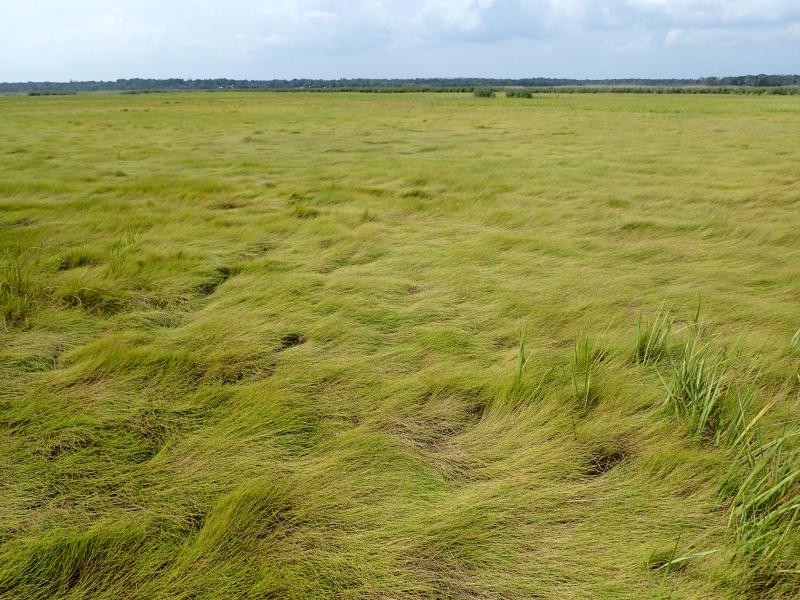
High Salt Marsh
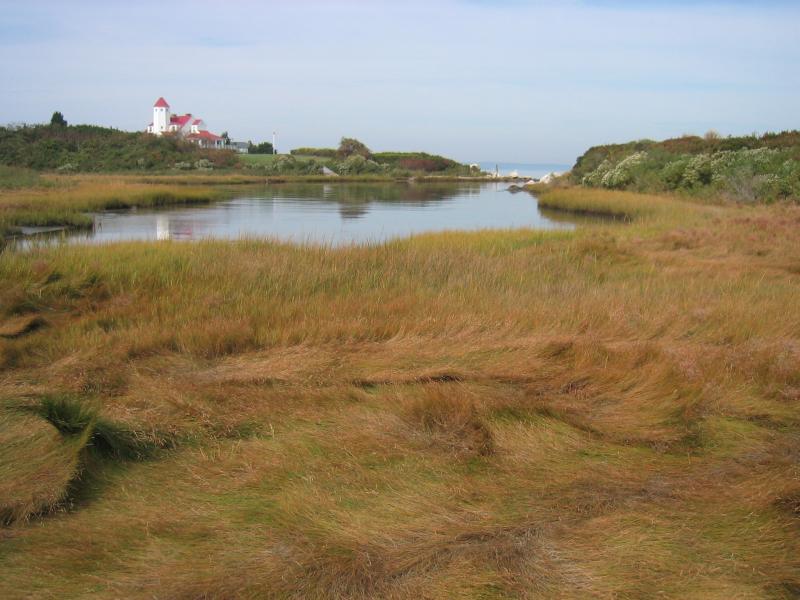
High salt marsh on Fishers Island
Gregory J. Edinger
- System
- Estuarine
- Subsystem
- Estuarine Intertidal
- State Protection
- Not Listed
Not listed or protected by New York State.
- Federal Protection
- Not Listed
- State Conservation Status Rank
- S1S2
Critically Imperiled or Imperiled in New York - Especially or very vulnerable to disappearing from New York due to rarity or other factors; typically 20 or fewer populations or locations in New York, very few individuals, very restricted range, few remaining acres (or miles of stream), and/or steep declines. More information is needed to assign either S1 or S2.
- Global Conservation Status Rank
- G4
Apparently Secure globally - Uncommon in the world but not rare; usually widespread, but may be rare in some parts of its range; possibly some cause for long-term concern due to declines or other factors.
Summary
Did you know?
At one time, salt-meadow grass (Spartina patens) was the backbone of Long Island's economy. During agriculture's early years on the Coastal Plain, this "salt marsh hay" was a staple forage crop for livestock. Presence of a marsh with salt hay was a major deciding factor in the settlement of new towns along the New England coast. These "salt meadows" were owned by the town and rights to mow and carry away the hay were auctioned off annually (Kavenagh 1980, Nixon 1982).
State Ranking Justification
There are an estimated 25 to 50 extant occurrences statewide. The several documented occurrences have good viability and most are protected on public land or private conservation land. The community is restricted to sheltered areas of the seacoast in the Coastal Lowlands and Manhattan Hills ecozones, and includes a few moderate sized, good quality examples. The current trend of the community is declining. Substantial primary threats, common to all salt marsh complexes, include ditching and draining, dredging and filling, common reed (Phragmites australis) invasion, poor water quality, diking and impoundment, inlet stabilization, shoreline hardening, wrack accumulation, altered sediment budget, subsidence, changes in water circulation patterns, restricted tidal connection, and altered tidal hydrodynamics.
Short-term Trends
In recent decades, particularly since 1922, the number, aerial extent, and quality of high salt marshes in New York has declined significantly. It is speculated that these losses are linked to the public works projects of the 1930s, including dredging and filling for major airport construction and urban development. Because high salt marshes are drier, closer to uplands, and easier to fill than low salt marshes, they are thought to have been disproportionately affected (Nixon 1982, O'Connor and Terry 1972). Declines have also been due to ditching for mosquito control; production of salt hay as a forage crop for livestock; and to pollution, including airborne particulates, pesticides, and sewage and stormwater discharge. It is suspected that losses will continue, resulting from ongoing shoreline development, declining water quality, and hydrologic alterations.
Long-term Trends
The number, aerial extent, and integrity of high salt marshes in New York are suspected to have declined substantially from their historical state. These declines are likely correlated with coastal development, ditching, filling, and changes in hydrology, water quality, and natural processes. Since the mid-1600's, high salt marshes in New England (presumably in New York) have been flooded, drained, impounded, diked, ditched, filled, used to produce forage crops (salt hay) for livestock, and/or extirpated by development (Nixon 1982).
Conservation and Management
Threats
Historical and continuing threats and disturbances include: dredging and filling for development, ditching and draining for mosquito control, common reed (Phragmites australis) invasion, poor water quality (from sewage and stormwater discharge; nonpoint source runoff; landfill leachate; boat traffic; particulate aircraft, vehicular, and power plant emissions; jet fuel; ethylene glycol from aircraft deicing; and pesticides used in mosquito management), diking and impoundment, inlet stabilization, shoreline hardening, wrack accumulation, altered sediment budget (decreased sediment input to marshes), subsidence, changes in water circulation patterns because of changes in shoreline and benthic topography, restricted tidal connection, and altered tidal hydrodynamics resulting from changes to hydrology (including groundwater levels, overland flow, and in-channel volume) in the surrounding watershed, road construction, and urbanization (GNRA and JBWPPAC 2007, Niedowski 2000, New York State Department of Environmental Conservation 2009b, 2009c, 2009d). Response to sea level rise is uncertain.
Conservation Strategies and Management Practices
Monitor the abundance of invasive species, particularly common reed (Phragmites australis), in this community and, as needed, control their encroachment. Remove excessive wrack accumulation. Remove shoreline armoring to increase overland sediment input; improve water quality by reducing or eliminating sewer and stormwater discharge and pesticide application; restore tidal regime by removing culverts, dikes, and impoundments, plugging ditches, and replacing static flow restriction devices with those that are calibrated for local tidal hydrology. Restoration and monitoring protocols are available (Niedowski 2000).
Development and Mitigation Considerations
Strive to minimize or eliminate hardened shorelines and maintain low-sloped shorelines within the tidal zone to increase overland sediment input. Maintain functional connectivity between the open ocean and bays with salt marsh complexes to enable full tidal flushing during each tidal cycle. For example, barriers such as railway causeways should have numerous culverts to allow sufficient hydrologic connectivity. If flow restriction devices are needed, those that are calibrated for local tidal hydrology can be used. Avoid dumping dredge spoil onto salt marshes. This community is best protected as part of a large salt marsh complex. Protected areas should encompass the full mosaic of low salt marsh, high salt marsh, marine intertidal mudflats, saltwater tidal creek, salt panne, and salt shrub communities to allow dynamic ecological processes (sedimentation, erosion, tidal flushing, and nutrient cycling) to continue. Connectivity to brackish and freshwater tidal communities, upland beaches and dunes, and to shallow offshore communities should be maintained. Connectivity between these habitats is important not only for nutrient flow and seed dispersal, but also for animals that move between them seasonally. Development of site conservation plans that identify wetland threats and their sources and provide management and protection recommendations would ensure their long-term viability.
Inventory Needs
Additional inventory is needed on the north and south shore of Long Island and in Peconic Bay. Leads include the nineteen sites that were not selected as reference wetlands by MacDonald and Edinger (2000). Data on rare and characteristic animals are needed.
Research Needs
Future research on high salt marsh should include monitoring community response to sea level rise, sediment starvation, and permanent flooding and studying nutrient exchange processes and relationships to adjacent communities (e.g., saltwater tidal creek, marine eelgrass meadow, low salt marsh, and maritime dunes). More research is needed to address the feasibility of reversing and/or minimizing the impacts that ditching and dredging have had on salt marshes (MacDonald and Edinger 2000).
Rare Species
- Agalinis maritima var. maritima (Seaside Agalinis) (guide)
- Ammodramus maritimus (Seaside Sparrow) (guide)
- Ardea alba (Great Egret) (guide)
- Asio flammeus (Short-eared Owl) (guide)
- Atriplex dioica (Thick-leaved Orach) (guide)
- Bartonia paniculata ssp. paniculata (Green Screwstem) (guide)
- Bolboschoenus maritimus ssp. paludosus (American Saltmarsh Bulrush) (guide)
- Bubulcus ibis (Cattle Egret) (guide)
- Carex hormathodes (Marsh Straw Sedge) (guide)
- Carex nigra (Black Sedge) (guide)
- Charadrius melodus (Piping Plover) (guide)
- Chenopodium berlandieri var. macrocalycium (Large-calyxed Goosefoot) (guide)
- Circus hudsonius (Northern Harrier) (guide)
- Cyperus echinatus (Globe Flat Sedge) (guide)
- Cyperus flavescens (Yellow Flat Sedge) (guide)
- Cyperus polystachyos var. texensis (Coast Flatsedge) (guide)
- Egretta caerulea (Little Blue Heron) (guide)
- Egretta thula (Snowy Egret) (guide)
- Egretta tricolor (Tricolored Heron) (guide)
- Eleocharis tuberculosa (Long-tubercled Spike Rush) (guide)
- Eleocharis uniglumis (Single-glumed Spike Rush) (guide)
- Erechtites hieraciifolius var. megalocarpus (Coastal Fireweed) (guide)
- Fimbristylis castanea (Marsh Fimbry) (guide)
- Gelochelidon nilotica (Gull-billed Tern) (guide)
- Helianthus angustifolius (Swamp Sunflower) (guide)
- Iris prismatica (Slender Blue Flag) (guide)
- Kinosternon subrubrum (Eastern Mud Turtle) (guide)
- Laterallus jamaicensis (Black Rail) (guide)
- Leucophaeus atricilla (Laughing Gull) (guide)
- Ligusticum scoticum ssp. scoticum (Scotch Lovage) (guide)
- Lythrum lineare (Saltmarsh Loosestrife) (guide)
- Nyctanassa violacea (Yellow-crowned Night-Heron) (guide)
- Plantago maritima var. juncoides (Seaside Plantain) (guide)
- Plegadis falcinellus (Glossy Ibis) (guide)
- Polygonum glaucum (Seabeach Knotweed) (guide)
- Potentilla anserina ssp. pacifica (Coastal Silverweed) (guide)
- Rumex fueginus (American Golden Dock) (guide)
- Rynchops niger (Black Skimmer) (guide)
- Sabatia campanulata (Slender Marsh Pink) (guide)
- Sabatia stellaris (Sea Pink) (guide)
- Salicornia bigelovii (Bigelow's Glasswort) (guide)
- Schinia gracilenta (Slender Flower Moth) (guide)
- Scutellaria integrifolia (Hyssop Skullcap) (guide)
- Solidago mexicana (Southern Seaside Goldenrod) (guide)
- Sterna dougallii (Roseate Tern) (guide)
- Sterna forsteri (Forster's Tern) (guide)
- Sterna hirundo (Common Tern) (guide)
- Suaeda linearis (Southern Sea Blite) (guide)
- Suaeda rolandii (Roland's Seablite) (guide)
- Symphyotrichum subulatum var. subulatum (Annual Saltmarsh Aster) (guide)
- Tripsacum dactyloides (Northern Gama Grass) (guide)
- Tyto alba (Barn Owl) (guide)
Range
New York State Distribution
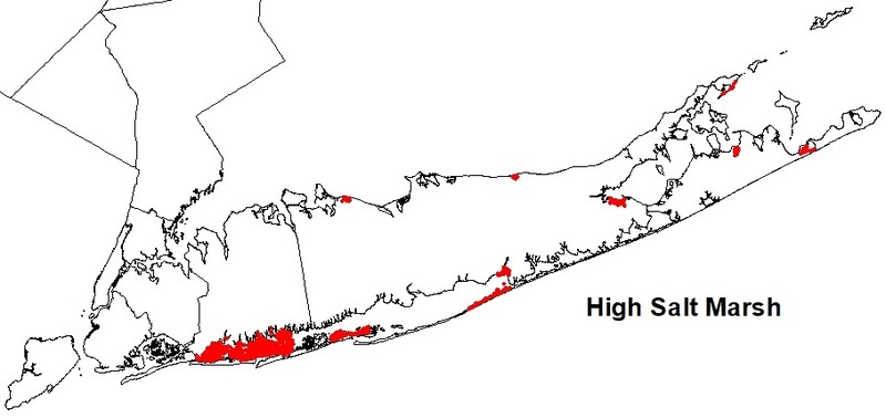
High salt marsh is restricted to sheltered areas of the seacoast in the Coastal Lowlands and Manhattan Hills ecozones. It is best developed in the Peconic Bay and along the south shore of Long Island. On the south shore, the greatest concentration occurs within the Hempstead Bay wetlands and nearly one half of Long Island's high salt marshes are located west of Gilgo Beach to Jamaica Bay. The community is rare and limited on the north shore (MacDonald and Edinger 2000).
Global Distribution
This high salt marsh community occurs from the Canadian maritime provinces south to Delaware (NatureServe 2009).
Best Places to See
- Jones Beach State Park (Nassau County)
- Napeague State Park (Suffolk County)
Identification Comments
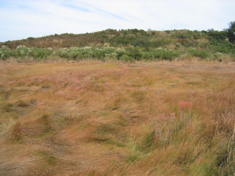
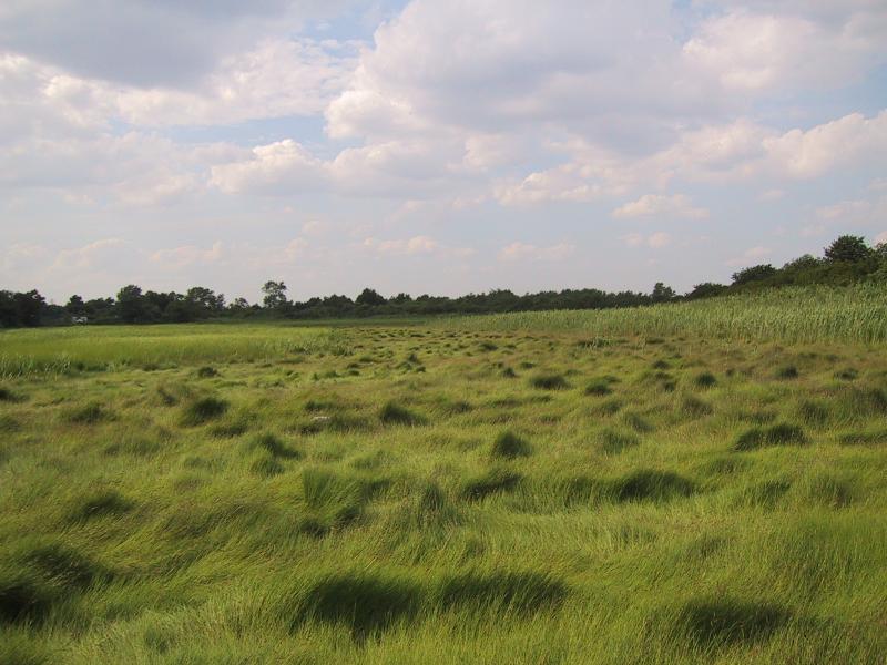
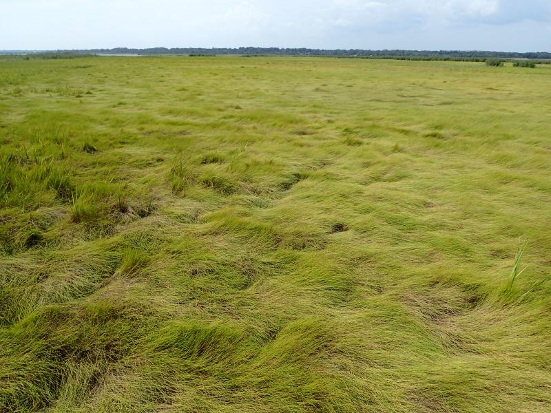
General Description
A coastal marsh community that occurs in sheltered areas of the seacoast, in a zone extending from mean high tide up to the limit of spring tides. It is periodically flooded by spring tides and incoming, rising tides. High salt marsh typically consists of a mosaic of patches that are mostly dominated by a single graminoid species. High salt marsh is part of the larger coastal salt marsh ecosystem; it occurs in a complex mosaic with several other communities. These communities include salt shrub and brackish meadow at the upland border of the high marsh; sea level fen, which, in rare cases, is associated with freshwater seepage at the landward edge; low salt marsh at the seaward border of the high marsh and along the edges of tidal creeks that drain the high marsh; and salt pannes in shallow depressions within the marsh.
Characters Most Useful for Identification
The dominant species in many large areas are either salt-meadow grass (Spartina patens) or a dwarf form (15 to 30 cm tall) of cordgrass (Spartina alterniflora); also common are large areas dominated by spikegrass (Distichlis spicata), black-grass (Juncus gerardii), and glassworts (Salicornia spp.), or a mixture of salt-meadow grass and cordgrass. Characteristic species of the upper slope of the high marsh (the area that grades into salt shrub) are black-grass, switchgrass (Panicum virgatum), sea-lavender (Limonium carolinianum), seaside gerardia (Agalinis maritima), and slender perennial saltmarsh aster (Symphyotrichum tenuifolium var. tenuifolium). Several birds nest in salt marshes, including marsh wren (Cistothorus palustris), saltmarsh sharp-tailed sparrow (Ammodramus caudacutus), red-winged blackbird (Agelaius phoeniceus), black-crowned night heron (Nycticorax nycticorax), Canada goose (Branta canadensis), American black duck (Anas rubripes), and sometimes clapper rail (Rallus longirostris) and willet (Catoptrophorus semipalmatus). Many more birds depend on salt marshes for food, such as green heron (Butorides striatus), great egret (Casmerodius albus), snowy egret (Egretta thula), glossy ibis (Plegadis falcinellus), tree swallow (Tachycineta bicolor), and terns (Sterna spp.) (Niedowski 2000). Other characteristic salt marsh faunas include salt marsh mosquitoes (Aedes spp.), greenhead flies (Tabanidae), coffeebean snail (Melampus bidentatus), and eastern meadowlark (Sturnella magna). A characteristic butterfly of the high salt marsh is the salt marsh skipper (Panoquina panoquin). The caterpillar feeds on spikegrass (Glassberg 1999, Robert Dirig pers. comm.)
Best Time to See
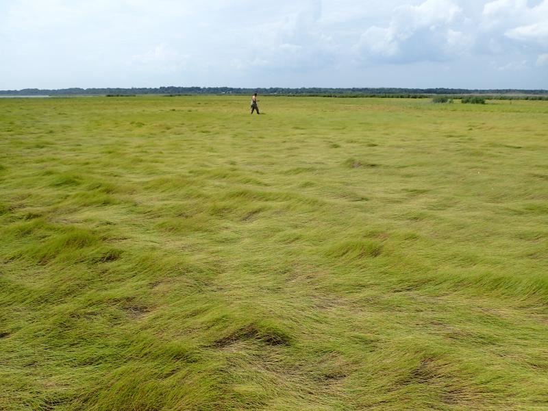
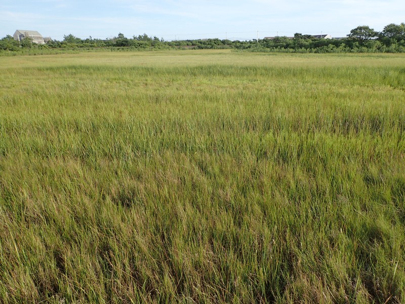
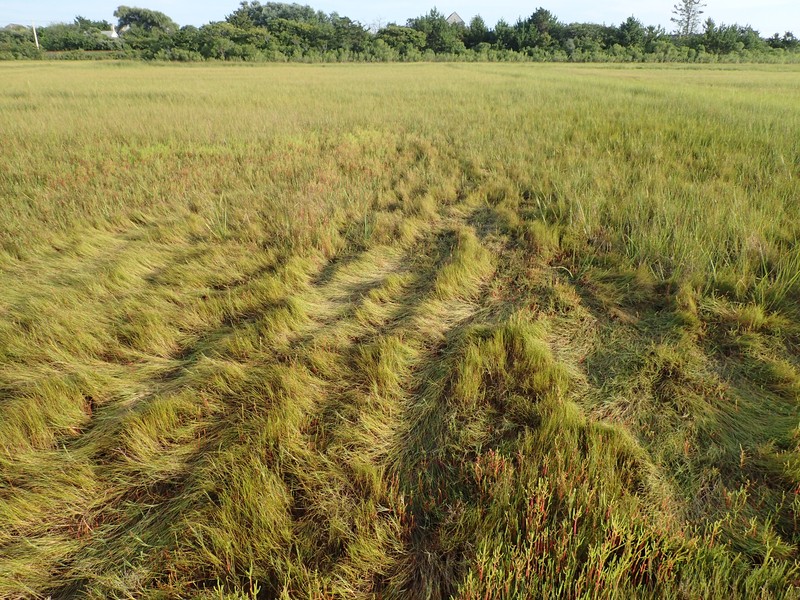
By mid-summer (July/August), salt-meadow grass has become tall enough to develop the flattened, circular 'cowlick' growth form that is characteristic of this community. The species is also blooming at that time, and its large florets provide a great opportunity to examine the unique structure of graminoid flowers.
High Salt Marsh Images
Gregory J. Edinger
Gregory J. Edinger
Aissa L. Feldmann
Gregory J. Edinger
Gregory J. Edinger
Gregory J. Edinger
Gregory J. Edinger
Gregory J. Edinger
Classification
International Vegetation Classification Associations
This New York natural community encompasses all or part of the concept of the following International Vegetation Classification (IVC) natural community associations. These are often described at finer resolution than New York's natural communities. The IVC is developed and maintained by NatureServe.
- Saltmeadow Cordgrass - Saltgrass - (Saltmeadow Rush) Salt Marsh (CEGL006006)
NatureServe Ecological Systems
This New York natural community falls into the following ecological system(s). Ecological systems are often described at a coarser resolution than New York's natural communities and tend to represent clusters of associations found in similar environments. The ecological systems project is developed and maintained by NatureServe.
- Northern Atlantic Coastal Plain Tidal Salt Marsh (CES203.519)
Characteristic Species
-
Shrubs 2 - 5m
- Iva frutescens (salt marsh-elder)
-
Shrubs < 2m
- Iva frutescens (salt marsh-elder)
-
Herbs
- Agalinis maritima var. maritima (seaside agalinis)
- Distichlis spicata (salt grass)
- Juncus gerardi (black-grass)
- Limonium carolinianum (sea-lavender)
- Panicum virgatum (switch grass)
- Phragmites australis (old world reed grass, old world phragmites)
- Salicornia bigelovii (Bigelow's glasswort)
- Salicornia depressa (slender glasswort)
- Schizachyrium scoparium var. scoparium (little bluestem)
- Schoenoplectus americanus (chair-maker's bulrush)
- Spartina alterniflora (smooth cord grass)
- Spartina patens (salt-meadow cord grass)
- Symphyotrichum tenuifolium var. tenuifolium (perennial salt marsh-aster)
Similar Ecological Communities
- Brackish meadow
(guide)
Brackish meadow usually occurs in close association with salt shrub and at slightly higher elevation than high salt marsh. It is dominated by switchgrass with salt-meadow grass and sedges. It may develop into high salt marsh in response to a more regular tidal influence if salt-meadow grass becomes dominant and a peat layer develops.
- Low salt marsh
(guide)
Low salt marsh is characterized by a near monoculture of cordgrass located at slightly lower elevation than high salt marsh. High marsh occurs in a mosaic, with patches that are dominated by salt-meadow grass, spikegrass, or a dwarf form (15 to 30 cm tall) of cordgrass.
- Maritime dunes
(guide)
Maritime dunes are terrestrial communities dominated by beachgrass located on active and stabilized dunes along the Atlantic coast. High salt marsh is an estuarine community that occurs at lower elevations with periodic tidal flooding; dominants include salt-meadow grass, spikegrass, or a dwarf form (15 to 30 cm tall) of cordgrass.
- Maritime grassland
(guide)
Maritime grassland is a terrestrial community with no tidal influence that is dominated by little bluestem, common hairgrass, and poverty-grass. High salt marsh is an estuarine community that occurs at lower elevations with periodic tidal flooding; dominants include salt-meadow grass, spikegrass, or a dwarf form (15 to 30 cm tall) of cordgrass.
Vegetation
Percent cover
This figure helps visualize the structure and "look" or "feel" of a typical High Salt Marsh. Each bar represents the amount of "coverage" for all the species growing at that height. Because layers overlap (shrubs may grow under trees, for example), the shaded regions can add up to more than 100%.
Additional Resources
References
Clark, J.S. 1985. The development of a tidal marsh: upland and oceanic influences. Ecol. Monogr. 55(2): 189-217.
Clark, J.S. 1986. Dynamism in the barrier-beach vegetation of Great South Beach, New York. Ecological Monographs 56(2):97-126.
Conard, H.S. 1935. The plant associations of central Long Island. American Midland Naturalist 16:433-515.
Edinger, G. J., D. J. Evans, S. Gebauer, T. G. Howard, D. M. Hunt, and A. M. Olivero (editors). 2014. Ecological Communities of New York State. Second Edition. A revised and expanded edition of Carol Reschke’s Ecological Communities of New York State. New York Natural Heritage Program, New York State Department of Environmental Conservation, Albany, NY. https://www.nynhp.org/ecological-communities/
Edinger, Gregory J., D.J. Evans, Shane Gebauer, Timothy G. Howard, David M. Hunt, and Adele M. Olivero (editors). 2002. Ecological Communities of New York State. Second Edition. A revised and expanded edition of Carol Reschke's Ecological Communities of New York State. (Draft for review). New York Natural Heritage Program, New York State Department of Environmental Conservation. Albany, NY. 136 pp.
Gateway National Recreation Area and Jamaica Bay Watershed Protection Plan Advisory Committee. 2007. An update on the disappearing salt marshes of Jamaica Bay, New York. Prepared by Gateway National Recreation Area, National Park Service, U.S. Department of the Interior and Jamaica Bay Watershed Protection Plan Advisory Committee, August 2, 2007.
Glassberg, J. 1999. Butterflies Through Binoculars: The East. Oxford University Press, New York, New York. 400 pp.
Kavenagh, W. Keith. 1980. Vanishing Tidelands: Land Use and Law in Suffolk County, N.Y. 1650-1979. New York Sea Grant Inst. Publ. RS-80-28. 265 pp.
MacDonald, Dana and Gregory Edinger. 2000. Identification of reference wetlands on Long Island, New York. Final report prepared for the Environmental Protection Agency, Wetland Grant CD992436-01. New York Natural Heritage Program, New York State Department of Environmental Conservation. Latham, NY. 106 pp. plus appendices.
NatureServe. 2009. NatureServe Explorer: An online encyclopedia of life [web application]. Version 7.1. NatureServe, Arlington, Virginia. Available http://www.natureserve.org/explorer. (Data last updated July 17, 2009)
New York Natural Heritage Program. 2024. New York Natural Heritage Program Databases. Albany, NY.
New York State Department of Environmental Conservation. 2009a. Tidal wetlands. Available http://www.dec.ny.gov/lands/4940.html. (Accessed: October 27, 2009)
New York State Department of Environmental Conservation. 2009b. Tidal wetland losses, Jamaica Bay, Queens County, NY.
New York State Department of Environmental Conservation. 2009c. Tidal wetland losses, Nassau and Suffolk Counties.
New York State Department of Environmental Conservation. 2009d. Tidal wetland losses, Strategy for Addressing Loss of Intertidal Marsh in the Marine District.
Niedowski, N.L. 2000. New York State salt marsh restoration and monitoring guidelines. Prepared for New York Department of State, Albany, NY, and New York Department of Environmental Conservation, East Setauket, NY.
Nixon, S.W. 1982. The ecology of New England high salt marshes: A community profile. U.S. Fish and Wildlife Service Office of Biological Services, Washington D.C. FWS/OBS-81/55. 70 pp.
O'Connor, J.S. and O.W. Terry. 1972. The marine wetlands of Nassau and Suffolk Counties, New York. Nassau-Suffolk Regional Planning Board and the Marine Science Research Center, SUNY-Stony Brook, N.Y. 99 pp.
Oertel, G.F. and H.J. Woo. 1994. Landscape classification and terminology for marsh in deficit coastal lagoons. Journal of Coastal Research. 10(4):919-932.
Packham, J.R. and A.J. Willis. 1997. Ecology of Dunes, Salt Marsh and Shingle. Chapman and Hall, London.
Redfield, A. C. 1972. Development of a New England salt marsh. Ecological Monographs 42:201-37.
Reschke, Carol. 1990. Ecological communities of New York State. New York Natural Heritage Program, New York State Department of Environmental Conservation. Latham, NY. 96 pp. plus xi.
Tolley, Patricia M. and Robert R. Christian. 1999. Effects of increased inundation and wrack deposition on a high salt marsh plant community. Estuaries and Coasts 22(4): 944-954.
United States Army Corps of Engineers. 1996. Fire Island to Montauk Point Long Island, New York. Breach contingency plan. Unpublished report. January. 45 pp.
United States Army Corps of Engineers. 1999. Fire Island Inlet to Montauk Point, Long Island, New York. Reach 1. Fire Island Inlet. Draft decision document, an evaluation of an interim plan for storm damage protection. Volume 1. Main report and draft environmental impact statement. United States Army Corps of Engineers. New York District.
Links
About This Guide
This guide was authored by: Aissa Feldmann
Information for this guide was last updated on: December 12, 2023
Please cite this page as:
New York Natural Heritage Program. 2024.
Online Conservation Guide for
High salt marsh.
Available from: https://guides.nynhp.org/high-salt-marsh/.
Accessed July 27, 2024.