American Golden Dock
Rumex fueginus Phil.
Rumex fueginus
Troy Weldy
- Class
- Dicotyledoneae (Dicots)
- Family
- Polygonaceae (Buckwheat Family)
- State Protection
- Endangered
Listed as Endangered by New York State: in imminent danger of extirpation in New York. For animals, taking, importation, transportation, or possession is prohibited, except under license or permit. For plants, removal or damage without the consent of the landowner is prohibited.
- Federal Protection
- Not Listed
- State Conservation Status Rank
- S1
Critically Imperiled in New York - Especially vulnerable to disappearing from New York due to extreme rarity or other factors; typically 5 or fewer populations or locations in New York, very few individuals, very restricted range, very few remaining acres (or miles of stream), and/or very steep declines.
- Global Conservation Status Rank
- G5
Secure globally - Common in the world; widespread and abundant (but may be rare in some parts of its range).
Summary
Did you know?
This species is known from Canada all the way south to the southern tip of South America, also known as Tierra del Fuego or Fuegia, thus the species name (Fernald 1950). It was named by Rodolfo Armando Philippi, a German-born scientist who moved to Chile in 1851 (Wikipedia contributors).
State Ranking Justification
There are six existing populations but two of them may have been destroyed by exotic invasive plants. Only one population has hundreds of plants and the rest have less than 50 each. There are 13 populations recorded from the late 1800s to 1971 which need to be rechecked. Three populations no longer exist because their habitat has been destroyed
Short-term Trends
The short term trend seems to indicate a sharp decline but only four of the six sites have been resurveyed since 1990. Two of the smaller populations may have vanished, and a third was substantially smaller, but other population increased to 400 plants which is a 4 to 8 times its initially documented size. The remaining two populations seen since 1984 have not been resurveyed but were small or modest with 3 and 50 plants respectively.
Long-term Trends
This species appears to have significantly declined in the last 100 years. Resurveys of the thirteen historical and additional three extant sites known from prior to 1990 are needed to confirm this decrease.
Conservation and Management
Threats
Direct disturbance by trampling and off road vehicle use are threats in unprotected beach and salt marsh habitat. Salt marsh and interdunal habitat is also threatened by the uncontrolled expansion of Phragmites.
Conservation Strategies and Management Practices
The saltmarshes need to be protected from the expansion of Phragmites into the areas where this plant grows. Natural buffers around the saltmarshes need to be maintained, and off-road vehicles excluded from the areas around known populations.
Research Needs
Propagation studies could be done to see if small populations can be augmented.
Habitat
Habitat
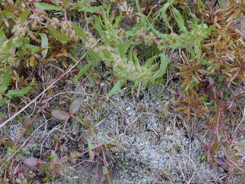
In New York Golden Dock has been almost exclusively in or adjacent to coastal wetlands, including barrier beaches, the edges of saltwater ponds and creeks, interdunal swales, and ballast areas. Saline habitats and possibly inland salt ponds or inland salt marshes represent the habitat of the species in the historical upstate records (New York Natural Heritage Program 2015). Saline, brackish or alkaline marshes and shores, as a weed in disturbed soil (Fernald 1970). Shores, streambanks, and wet ground, avoiding acid soils (Gleason & Cronquist 1991).
Associated Ecological Communities
- Brackish interdunal swales
(guide)
Temporarily tidally flooded temperate marshes in interdunal swales dominated by salt-tolerant graminoids. Individual swales occur as small patches positioned between fore-, primary and secondary dunes in a maritime dunes system, typically on barrier islands.
- Brackish intertidal shore
A community of the intertidal gravelly or rocky shores of brackish tidal rivers and creeks where water salinity ranges from 0.5 to 18.0 ppt.
- Brackish meadow*
(guide)
A moist, moderately well-drained brackish (salinity 0.5-18 ppt) perennial grassland with occasional isolated shrubs that is typically situated in a belt at the upper edge of salt marshes bordering sandy uplands, but may occupy large portions of interdunal basins. The community usually develops in areas with a unique combination of soils and hydrology, on deep deposits of periodically windblown or overwashed gleyed sands that are usually flooded only during spring tides and during major coastal storms, approximately two to three times per year.
- Brackish tidal marsh*
(guide)
A marsh community that occurs where water salinity ranges from 0.5 to 18.0 ppt, and water is less than 2 m (6 ft) deep at high tide. The vegetation in a brackish tidal marsh is dense and dominated by tall grass-like plants.
- Coastal salt pond*
(guide)
A community inhabiting marine shoreline lakes or ponds formed by sandspits that close off a lagoon or bay. The water typically averages brackish or slightly brackish over long periods of time, but may range rapidly from fresh to saline.
- High salt marsh*
(guide)
A coastal marsh community that occurs in sheltered areas of the seacoast, in a zone extending from mean high tide up to the limit of spring tides. It is periodically flooded by spring tides and flood tides. High salt marshes typically consist of a mosaic of patches that are mostly dominated by a single graminoid species.
- Inland salt marsh*
(guide)
A wetland that occurs on saline mudflats associated with inland salt springs. The mucky substrate is permanently saturated and seasonally flooded. Plant cover is sparse and the number of different kinds of plants is relatively low.
- Low salt marsh*
(guide)
A coastal marsh community that occurs in sheltered areas of the seacoast, in a zone extending from mean high tide down to mean sea level or to about 2 m (6 ft) below mean high tide. It is regularly flooded by semidiurnal tides. The mean tidal range of low salt marshes on Long Island is about 80 cm, and they often form in basins with a depth of 1.6 m or greater.
- Maritime beach
(guide)
A community with extremely sparse vegetation that occurs on unstable sand, gravel, or cobble ocean shores above mean high tide, where the shore is modified by storm waves and wind erosion.
- Saltwater tidal creek
(guide)
The aquatic community of a shallow, tidally flooded saltwater or brackish creek with submerged areas averaging less than 2 m (6 ft) deep at low tide.
* probable association but not confirmed.
Associated Species
- Aster spp.
- Cakile edentula
- Chenopodium rubrum
- Cyperus spp.
- Eleocharis spp.
- Fuirena pumila (dwarf umbrella-grass)
- Pluchea odorata var. succulenta
- Samolus valerandi (water pimpernel, brookweed)
Range
New York State Distribution
This wetland plant is currently known from Nassau and Suffolk counties on Long Island. There are historical records from Queens and Delaware counties, and from scattered counties of the Finger Lakes and Buffalo area.
Global Distribution
In the U.S. Golden Dock is common west of the Mississippi River north of Arkansas and Oklahoma, with scattered populations in Texas. Its range extends east across the northern tier of states, where it becomes rare from Ohio east to New Jersey, New York and New England. It has a circumpolar distribution globally.
Identification Comments
Identifying Characteristics
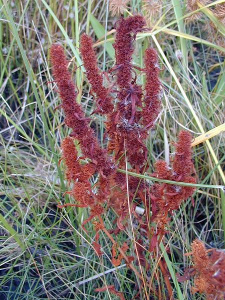
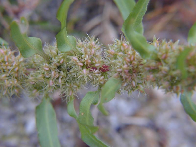
Golden Dock is an annual (or sometimes biennial) herb species with erect stems normally 15 to 60 centimeters tall. Like other members of the buckwheat family, the stems are swollen at the nodes. The leaves are 5 to 25 centimeters long, lanceolate (lance-shaped) or linear-lanceolate, with wavy margins. The infloresence is terminal, with 15 to 30 tiny (1 to 3 millimeter) densely packed flowers, reddish-brown to red early, then turning greenish yellow when mature. Upon maturity, the inner tepals of Rumex flowers form structures called valves, surrounding the fruit (achenes). The midrib of one of these valves forms a protruding structure called a tubercle. The brown achenes of Rumex fueginus has turbercles twice as wide (2.5 to 3.5 millimeters) as the achenes themselves (FNA 2005).
Best Life Stage for Proper Identification
Plants with mature fruits are necessary for identification.
Similar Species
R. persicarioides occupies similar habitats to R. fueginus and was historically known from New York, though there are no known extant records.The valves enclosing the achenes of Rumex persicarioides have much shorter (0.5-1.5 millimeters) wings, about as long as the width of the inner tepals, and the tubercle covering the achene is broad, rounded, and straw- colored. In contrast R. fueginus has valves with wings 1.5 to 2.5 times as long as the width of the inner tepals, and brown or reddish, narrow, lanceolate tubercles.
Best Time to See
Golden Dock flowers from July through August, and the fruits persist through September and October.
- Flowering
- Fruiting
The time of year you would expect to find American Golden Dock flowering and fruiting in New York.
American Golden Dock Images
Troy Weldy
Troy Weldy
Troy Weldy
Taxonomy
American Golden Dock
Rumex fueginus Phil.
- Kingdom Plantae
- Phylum Anthophyta
- Class Dicotyledoneae
(Dicots)
- Order Polygonales
- Family Polygonaceae (Buckwheat Family)
- Order Polygonales
- Class Dicotyledoneae
(Dicots)
- Phylum Anthophyta
Additional Common Names
- Golden Dock
- Seashore Dock
Synonyms
- Rumex maritimus var. athrix St. John
Additional Resources
Best Identification Reference
Flora of North America Editorial Committee. 2005. Flora of North America North of Mexico, Volume 5, Magnoliophyta: Caryophyllidae, Part 2. Oxford University Press, New York.
Other References
Fernald, M.L. 1950. Gray's manual of botany. 8th edition. D. Van Nostrand, New York. 1632 pp.
Gleason, Henry A. and A. Cronquist. 1991. Manual of Vascular Plants of Northeastern United States and Adjacent Canada. The New York Botanical Garden, Bronx, New York. 910 pp.
Holmgren, Noel. 1998. The Illustrated Companion to Gleason and Cronquist's Manual. Illustrations of the Vascular Plants of Northeastern United States and Adjacent Canada. The New York Botanical Garden, Bronx, New York.
House, Homer D. 1924. Annotated list of the ferns and flowering plants of New York State. New York State Museum Bulletin 254:1-758.
Mitchell, Richard S. and Gordon C. Tucker. 1997. Revised Checklist of New York State Plants. Contributions to a Flora of New York State. Checklist IV. Bulletin No. 490. New York State Museum. Albany, NY. 400 pp.
Mitchell, Richard S. and J. Kenneth Dean. 1978. Polygonaceae (buckwheat family) of New York State. Contributions to a flora of New York State. Richard S. Mitchell, ed. New York State Museum Bulletin No. 431. 79 pp.
New York Natural Heritage Program. 2010. Biotics database. New York Natural Heritage Program. New York State Department of Environmental Conservation. Albany, NY.
New York Natural Heritage Program. 2024. New York Natural Heritage Program Databases. Albany, NY.
Reschke, Carol. 1990. Ecological communities of New York State. New York Natural Heritage Program, New York State Department of Environmental Conservation. Latham, NY. 96 pp. plus xi.
Weldy, T. and D. Werier. 2010. New York flora atlas. [S.M. Landry, K.N. Campbell, and L.D. Mabe (original application development), Florida Center for Community Design and Research http://www.fccdr.usf.edu/. University of South Florida http://www.usf.edu/]. New York Flora Association http://newyork.plantatlas.usf.edu/, Albany, New York
Links
About This Guide
This guide was authored by: Stephen M. Young and Richard M. Ring
Information for this guide was last updated on: January 23, 2012
Please cite this page as:
New York Natural Heritage Program. 2024.
Online Conservation Guide for
Rumex fueginus.
Available from: https://guides.nynhp.org/golden-dock/.
Accessed July 27, 2024.