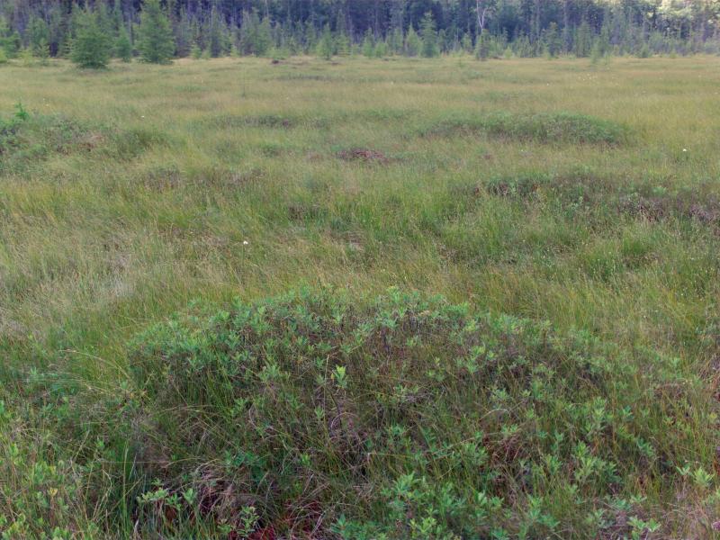
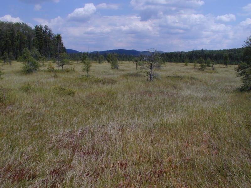
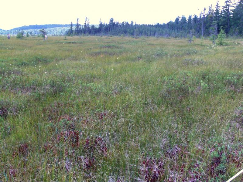
Patterned Peatland
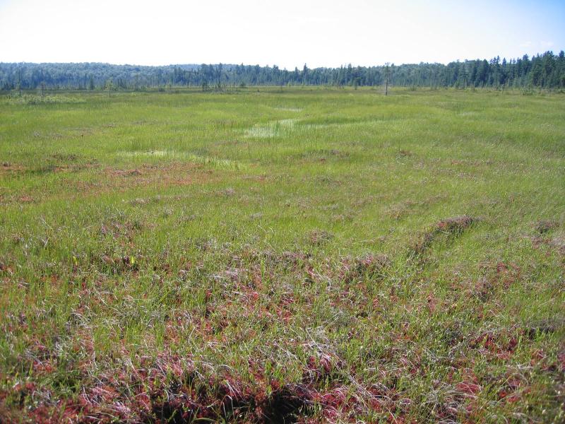
Patterned peatland at Spring Pond Bog.
Gregory J. Edinger
- System
- Palustrine
- Subsystem
- Open Peatlands
- State Protection
- Not Listed
Not listed or protected by New York State.
- Federal Protection
- Not Listed
- State Conservation Status Rank
- S1
Critically Imperiled in New York - Especially vulnerable to disappearing from New York due to extreme rarity or other factors; typically 5 or fewer populations or locations in New York, very few individuals, very restricted range, very few remaining acres (or miles of stream), and/or very steep declines.
- Global Conservation Status Rank
- G3G4
Vulnerable globally, or Apparently Secure - At moderate risk of extinction, with relatively few populations or locations in the world, few individuals, and/or restricted range; or uncommon but not rare globally; may be rare in some parts of its range; possibly some cause for long-term concern due to declines or other factors. More information is needed to assign either G3 or G4.
Summary
Did you know?
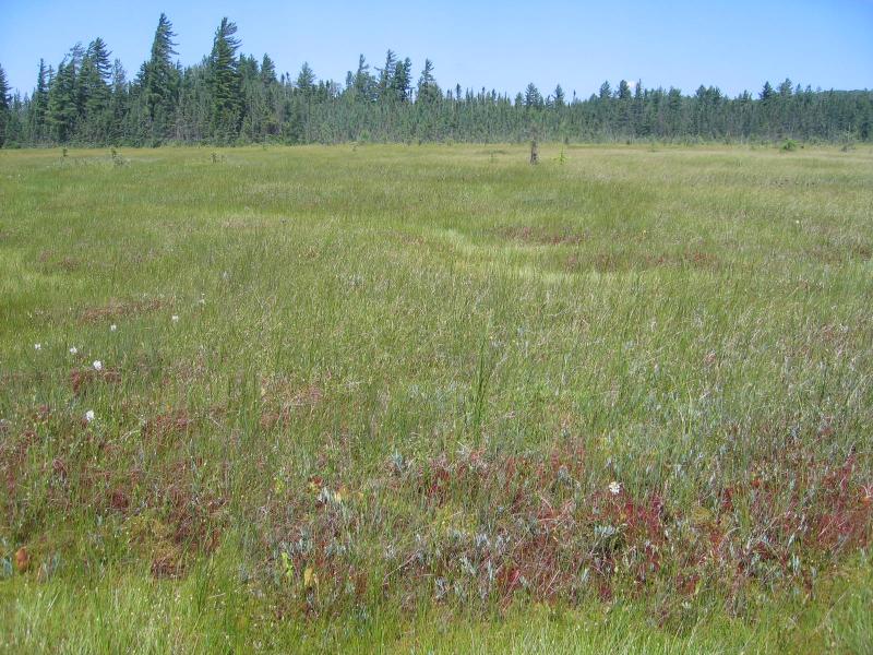
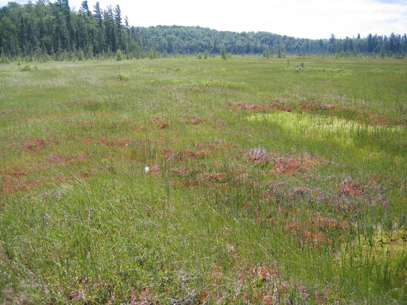
Patterned peatlands are characterized by distinct microtopographic patterns that form strings and flarks parallel to the wetland basin's slope and perpendicular to the underlying groundwater flow. Strings are low elevated ridges of peat vegetated primarily by low shrubs, sedges and the occasional stunted tree. Flarks are low swales or hollows that are open, wet Sphagnum lawns with sedges and rushes as their representative species.
State Ranking Justification
There are probably less than five occurrences of patterned peatland in New York where it reaches its southern limit in North America. Patterned peatlands are limited to the largest peatland areas in the Adirondacks where water flow is sufficient to form strings and flarks. Currently documented occurrences are protected on state land or private conservation land.
Short-term Trends
The numbers and acreage of patterned peatlands in New York have probably remained stable in recent decades as a result of wetland protection regulations and land conservation efforts. There may be cases of slight decline due to alterations of peatland hydrology.
Long-term Trends
Given their limited historical distribution, the numbers and acreage of patterned peatlands in New York have probably remained relatively stable within the last few hundred years.
Conservation and Management
Threats
Ditching and other hydrological alterations associated with the construction and maintanence of road and trails and the use of off-road vehicles are significant threats. Sedimentation and runoff from development, nearby logging, or land clearing is also a potential threat where adequate buffers are lacking.
Conservation Strategies and Management Practices
Where practical, establish and maintain a natural wetland and upland buffer to reduce storm-water, pollution, and nutrient run-off, while simultaneously capturing sediments before they reach the wetland. Buffer width should take into account the erodibility of the surrounding soils, slope steepness, and current land use. Wetlands protected under Article 24 are known as New York State "regulated" wetlands. The regulated area includes the wetlands themselves as well as a protective buffer or "adjacent area" extending 100 feet landward of the wetland boundary (NYS DEC 1995). If possible, minimize the number and size of impervious surfaces in the surrounding landscape. Avoid habitat alteration within the wetland and surrounding landscape. For example, roads and trails should be routed around wetlands, and ideally not pass through the buffer area. If the wetland must be crossed, then bridges and boardwalks are preferred over filling. Restore past impacts, such as removing obsolete impoundments and ditches, in order to restore the natural hydrology. Prevent the spread of invasive exotic species into the wetland through appropriate direct management and by minimizing potential dispersal corridors, such as roads.
Development and Mitigation Considerations
When considering road construction and other development activities, minimize actions that will change what water carries and how water travels to and from this community, both on the surface and underground. Water traveling over-the-ground as runoff usually carries an abundance of silt, clay, and other particulates during (and often after) a construction project. While still suspended in the water, these particulates make it difficult for aquatic animals to find food; after settling to the bottom of the system, they bury small plants and animals and alter the natural functions of the community in many other ways. Thus, road construction and development activities near this community type should strive to minimize particulate-laden run-off into this community. Water traveling on the ground or seeping through the ground also carries dissolved minerals and chemicals. Road salt, for example, is becoming an increasing problem both to natural communities and as a contaminant in household wells. Fertilizers, detergents, and other chemicals that increase the nutrient levels in wetlands cause algal blooms and eventually an oxygen-depleted environment in which few animals can live. Herbicides and pesticides often travel far from where they are applied and have lasting effects on the quality of the natural community. So, road construction and other development activities should strive to consider how water moves through the ground, the types of dissolved substances these development activities may release, and how to minimize the potential for these dissolved substances to reach this natural community.
Inventory Needs
More quantitative data on vascular and nonvascular composition, including characteristic bryophytes of this community are needed. Maps of the vegetation patterns at each site are needed, as is monitoring of permanent plots to assess changes in composition and hydrology.
Research Needs
Research is needed to fill information gaps about patterned peatlands, especially to advance our understanding of their classification, ecological processes (e.g., fire and response to global climate change), hydrology, floristic variation, characteristic fauna, development, and succession. This research will provide the basic facts necessary to assess how human alterations in the landscape affect peatlands and will supply a framework for evaluating the relative ecological and conservation value of peat bogs (Damman and French 1987).
Rare Species
- Aeshna subarctica (Subarctic Darner) (guide)
- Betula pumila (Swamp Birch) (guide)
- Carex haydenii (Cloud Sedge) (guide)
- Carex wiegandii (Wiegand's Sedge) (guide)
- Euphagus carolinus (Rusty Blackbird) (guide)
- Platanthera ciliaris (Orange Fringed Orchid) (guide)
- Salix pyrifolia (Balsam Willow) (guide)
- Scheuchzeria palustris (Pod Grass) (guide)
Range
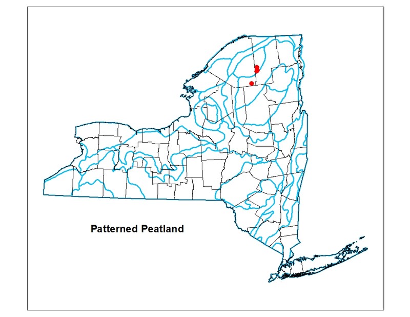
New York State Distribution
Currently this community is restricted to the north-central Adirondacks which represents the southeastern extreme of its range. The historical range of patterned peatlands in New York is unknown and may have extended through the Adirondack foothills.
Global Distribution
This community is limited to Canada and the northern border of the eastern U.S. This range is estimated to span north to northern Ontario and Quebec, west to Minnesota and Alberta, southeast to New York and Maine, and northeast to New Brunswick and Newfoundland.
Best Places to See
- Spring Pond Bog (permission required)
- Hitchins Pond Bog North, Eastern Five Ponds Primitive Area (St. Lawrence County)
Identification Comments
General Description
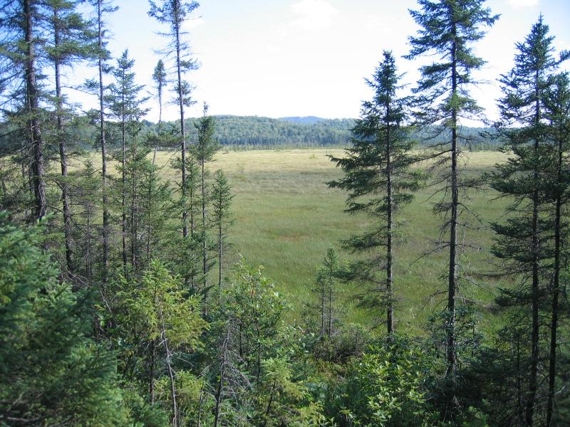
An open peatland with a gentle slope or divide in which the vegetation consists of a repeating pattern of high and low areas (relative to water levels) that are called strings and flarks, respectively. These features occur as narrow or broad bands of vegetation that extend perpendicular to the direction of water flow across the slope of the peatland, and are arrayed in a parallel or mottled manner. The strings, or hummocks (high, relatively dry areas), are usually ombrotrophic or weakly minerotrophic, and the flarks, or hollows (low, relatively wet areas), are more minerotrophic. In New York, the most pronounced patterning occurs in three bogs that are primarily ombrotrophic and are slightly raised at the center. These bogs have a subtle ladderform pattern of slightly raised linear hummocks (strings) and broad, shallow hollows (flarks) along one of the slopes, as well as several small ponds.
Characters Most Useful for Identification
This open peatland community has two distinct sets of species, those of the flarks (low, wet areas) and those of the strings (often linear trending, drier hummocks). Peat mosses (Sphagnum spp.) are the dominant species throughout. The vegetation of the flarks is characterized by peat mosses, sedges, and herbs including Sphagnum cuspidatum, S. majus, white beakrush (Rhynchospora alba), sedges (Carex exilis), and pitcher-plant (Sarracenia purpurea). Vegetation of the strings is predominantly peat mosses and low ericaceous shrubs with a complement of sedges. Sphagnum rubellum is common and the most prevalent shrubs are leatherleaf (Chamaedaphne calyculata), Labrador tea (Rhododendron groenlandicum), bog laurel (Kalmia polifolia), sheep laurel (Kalmia angustifolia), bog rosemary (Andromeda polifolia var. glaucophylla), and small cranberry (Vaccinium oxycoccos). The sedges cottongrass (Eriophorum vaginatum) and few-seeded sedge (C. oligosperma) occur in both flarks and strings.
Elevation Range
Known examples of this community have been found at elevations between 1,540 feet and 1,732 feet.
Best Time to See
Early summer when the various shrub species are in full bloom is a particularly picturesque period to visit this peatland community.
Patterned Peatland Images
Gregory J. Edinger

Gregory J. Edinger
Elizabeth A. Spencer
Troy Weldy
Elizabeth A. Spencer
Gregory J. Edinger
Gregory J. Edinger
Gregory J. Edinger
Classification
International Vegetation Classification Associations
This New York natural community encompasses all or part of the concept of the following International Vegetation Classification (IVC) natural community associations. These are often described at finer resolution than New York's natural communities. The IVC is developed and maintained by NatureServe.
- Mud Sedge - White Beaksedge / Beautiful Peatmoss - Notchwort species Fen (CEGL006522)
- Leatherleaf / Tawny Cottongrass / Red Peatmoss Acidic Peatland (CEGL006513)
NatureServe Ecological Systems
This New York natural community falls into the following ecological system(s). Ecological systems are often described at a coarser resolution than New York's natural communities and tend to represent clusters of associations found in similar environments. The ecological systems project is developed and maintained by NatureServe.
- Eastern Boreal-Sub-boreal Acidic Basin Fen (CES201.583)
- Eastern Boreal-Sub-boreal Bog (CES103.581)
- North-Central Interior and Appalachian Acidic Peatland (CES202.606)
Characteristic Species
-
Shrubs < 2m
- Andromeda polifolia var. latifolia (bog-rosemary)
- Aronia melanocarpa (black chokeberry)
- Chamaedaphne calyculata (leatherleaf)
- Ilex mucronata (mountain holly)
- Kalmia angustifolia var. angustifolia (sheep laurel, sheep-kill)
- Kalmia polifolia (bog laurel)
- Rhododendron groenlandicum (Labrador-tea)
- Vaccinium angustifolium (common lowbush blueberry)
- Vaccinium oxycoccos (small cranberry)
-
Tree saplings
- Larix laricina (tamarack)
- Picea mariana (black spruce)
-
Herbs
- Calamagrostis pickeringii (Pickering's reed grass)
- Carex exilis (meager sedge)
- Carex magellanica ssp. irrigua (bog sedge)
- Carex oligosperma (few-seeded sedge)
- Carex pauciflora (few-flowered sedge)
- Carex trisperma (three-fruited sedge)
- Eriophorum vaginatum (tussock cotton-grass)
- Eriophorum virginicum (tawny cotton-grass)
- Platanthera blephariglottis var. blephariglottis (white fringed orchid)
- Rhynchospora alba (white beak sedge)
- Sarracenia purpurea (purple pitcherplant)
- Scheuchzeria palustris (pod-grass)
- Trichophorum alpinum (lime-loving club sedge)
-
Nonvascular plants
- Sphagnum angustifolium
- Sphagnum cuspidatum
- Sphagnum majus
- Sphagnum rubellum
Similar Ecological Communities
- Dwarf shrub bog
(guide)
Dwarf shrub bogs are peatland communities dominated by dwarf shrubs (>50% shrub cover) and Sphagnum species but lacking the distinct interspersed drier hummocks (strings) and extensive low, wet hollows (flarks).
- Inland poor fen
(guide)
Inland poor fens are Sphagnum- and graminoid-dominated (< 50% shrub cover), weakly mineotrophic peatlands occuring as moist to wet flat lawns or low undulating carpets.
Vegetation
Percent cover
This figure helps visualize the structure and "look" or "feel" of a typical Patterned Peatland. Each bar represents the amount of "coverage" for all the species growing at that height. Because layers overlap (shrubs may grow under trees, for example), the shaded regions can add up to more than 100%.
Additional Resources
References
Cowardin, L.M., V. Carter, F.C. Golet, and E.T. La Roe. 1979. Classification of wetlands and deepwater habitats of the United States. U.S. Fish and Wildlife Service. Washington, D.C. 131 pp.
Damman, A.W.H. and T.W. French. 1987. The ecology of peat bogs of the glaciated northeastern United States: a community profile. U.S. Fish and Wildlife Service Biological Report 85(7.16). 100 pp.
Edinger, G. J., D. J. Evans, S. Gebauer, T. G. Howard, D. M. Hunt, and A. M. Olivero (editors). 2014. Ecological Communities of New York State. Second Edition. A revised and expanded edition of Carol Reschke’s Ecological Communities of New York State. New York Natural Heritage Program, New York State Department of Environmental Conservation, Albany, NY. https://www.nynhp.org/ecological-communities/
Edinger, Gregory J., D.J. Evans, Shane Gebauer, Timothy G. Howard, David M. Hunt, and Adele M. Olivero (editors). 2002. Ecological Communities of New York State. Second Edition. A revised and expanded edition of Carol Reschke's Ecological Communities of New York State. (Draft for review). New York Natural Heritage Program, New York State Department of Environmental Conservation. Albany, NY. 136 pp.
Kost, M.A., D.A. Albert, J.G. Cohen, B.S. Slaughter, R.K. Schillo, C.R. Weber, and K.A. Chapman. 2007. Natural Communities of Michigan: Classification and Description. Michigan Natural Features Inventory, Report No. 2007-21, Lansing, MI.
New York Natural Heritage Program. 2024. New York Natural Heritage Program Databases. Albany, NY.
New York State Department of Environmental Conservation. 1995. Freshwater Wetlands: Delineation Manual. July 1995. New York State Department of Environmental Conservation. Division of Fish, Wildlife, and Marine Resources. Bureau of Habitat. Albany, NY.
Reschke, Carol. 1990. Ecological communities of New York State. New York Natural Heritage Program, New York State Department of Environmental Conservation. Latham, NY. 96 pp. plus xi.
Slaughter, B.S., and J.G. Cohen. 2010. Natural community abstract for patterned fen. Michigan Natural Features Inventory, Lansing, MI. 34 pp.
Links
About This Guide
This guide was authored by: Elizabeth Spencer
Information for this guide was last updated on: April 3, 2024
Please cite this page as:
New York Natural Heritage Program. 2024.
Online Conservation Guide for
Patterned peatland.
Available from: https://guides.nynhp.org/patterned-peatland/.
Accessed July 26, 2024.