Slender Blue Flag
Iris prismatica Pursh ex Ker-Gawl.
Kimberly J. Smith
- Class
- Monocotyledoneae (Monocots)
- Family
- Iridaceae (Iris Family)
- State Protection
- Threatened
Listed as Threatened by New York State: likely to become Endangered in the foreseeable future. For animals, taking, importation, transportation, or possession is prohibited, except under license or permit. For plants, removal or damage without the consent of the landowner is prohibited.
- Federal Protection
- Not Listed
- State Conservation Status Rank
- S2
Imperiled in New York - Very vulnerable to disappearing from New York due to rarity or other factors; typically 6 to 20 populations or locations in New York, very few individuals, very restricted range, few remaining acres (or miles of stream), and/or steep declines.
- Global Conservation Status Rank
- G4G5
Apparently or Demonstrably Secure globally - Uncommon to common in the world, but not rare; usually widespread, but may be rare in some parts of its range; possibly some cause for long-term concern due to declines or other factors. More information is needed to assign either G4 or G5.
Summary
Did you know?
The roots and rhizomes contain the glycoside iridin that is somewhat poisonous and a skin irritant (Lady Bird Johnson Wildflower Center 2010). That is why it sometimes has the common name poison flagroot.
State Ranking Justification
There are 15 existing populations and about half of these have 100 plants are more. Three populations have over 1000 plants. Forty-one populations were documented from the late 1800s through the 1960s but about half of these no longer exist because their habitat has been destroyed. About 20 populations need to be checked to determine if they still exist.
Short-term Trends
Most populations have been visited more than once and they seem stable.
Long-term Trends
Populations have declined by over one half in the last 100 years as many wetlands in the New York City area and Western Long Island have been destroyed. If the remaining wetlands can be preserved and managed well then populations should remain viable into the foreseeable future.
Conservation and Management
Threats
Populations are threatened by off-road vehicles, trampling, mosquito ditches, fragmentation and hydrological alteration from a road crossing and by the expansion of stands of Phragmites.
Conservation Strategies and Management Practices
Wetlands need to have sufficient natural buffers established around them to preserve hydrology and invasive species, especially Phragmites, need to be controlled.
Habitat
Habitat
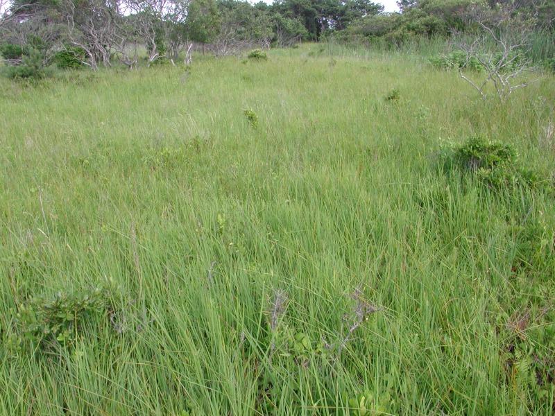
In New York Slender Blue Flag is known from a variety of open, wet, coastal habitats. It has been collected in sea level fens and the edges of salt marshes and brackish meadows, as well as from diverse disturbed habitats such as burned or scraped old fields, ditches, and roadside swales (New York Natural Heritage Program 2010). Swampy, peaty soil (FNA 2002). Moist meadows and sandy or gravelly shores (Rhoads and Block 2000). Marshes, swamps, and damp meadows (Gleason and Cronquist 1991).
Associated Ecological Communities
- Brackish interdunal swales*
(guide)
Temporarily tidally flooded temperate marshes in interdunal swales dominated by salt-tolerant graminoids. Individual swales occur as small patches positioned between fore-, primary and secondary dunes in a maritime dunes system, typically on barrier islands.
- Brackish meadow
(guide)
A moist, moderately well-drained brackish (salinity 0.5-18 ppt) perennial grassland with occasional isolated shrubs that is typically situated in a belt at the upper edge of salt marshes bordering sandy uplands, but may occupy large portions of interdunal basins. The community usually develops in areas with a unique combination of soils and hydrology, on deep deposits of periodically windblown or overwashed gleyed sands that are usually flooded only during spring tides and during major coastal storms, approximately two to three times per year.
- Coastal plain pond*
(guide)
The aquatic community of the permanently flooded portion of a coastal plain pond with seasonally, and annually fluctuating water levels. These are shallow, groundwater-fed ponds that occur in kettle-holes or shallow depressions in the outwash plains south of the terminal moraines of Long Island, and New England. A series of coastal plain ponds are often hydrologically connected, either by groundwater, or sometimes by surface flow in a small coastal plain stream.
- Coastal plain pond shore
(guide)
The gently sloping shore of a coastal plain pond with seasonally and annually fluctuating water levels. Plants growing on the pond shore vary with water levels. In dry years when water levels are low there is often a dense growth of annual sedges, grasses, and herbs. Submerged and floating-leaved aquatic plants, such as fragrant waterlily and pondweeds, may become "stranded" on the exposed shore. In wet years when the water level is high only a few emergents and floating-leaved aquatics may be noticeable. T
- Ditch/artificial intermittent stream
The aquatic community of an artificial waterway constructed for drainage or irrigation of adjacent lands. Water levels either fluctuate in response to variations in precipitation and groundwater levels, or water levels are artificially controlled.
- High salt marsh
(guide)
A coastal marsh community that occurs in sheltered areas of the seacoast, in a zone extending from mean high tide up to the limit of spring tides. It is periodically flooded by spring tides and flood tides. High salt marshes typically consist of a mosaic of patches that are mostly dominated by a single graminoid species.
- Maritime shrubland
(guide)
A shrubland community that occurs on dry seaside bluffs and headlands that are exposed to offshore winds and salt spray.
- Mowed roadside/pathway
A narrow strip of mowed vegetation along the side of a road, or a mowed pathway through taller vegetation (e.g., meadows, old fields, woodlands, forests), or along utility right-of-way corridors (e.g., power lines, telephone lines, gas pipelines). The vegetation in these mowed strips and paths may be dominated by grasses, sedges, and rushes; or it may be dominated by forbs, vines, and low shrubs that can tolerate infrequent mowing.
- Rich graminoid fen*
(guide)
A wetland of mostly grasses usually fed by water from highly calcareous springs or seepage. These waters have high concentrations of minerals and high pH values, generally from 6.0 to 7.8. Plant remains do not decompose rapidly and these grasses usually grow on older, undecomposed plant parts.
- Sea level fen
(guide)
A wetland that occurs at the upper edge of salt marshes but is fed primarily by acidic groundwater seeping out along the upland edge. This fresh water sometimes mixes with salt or brackish water during unusually high tides. There is a high abundance of sedges that decompose slowly and create a deep substrate of peat. This peat is underlain by deep sand or gravel. These fens usually have a high diversity of herbs but may also have scattered trees and shrubs.
- Successional old field*
A meadow dominated by forbs and grasses that occurs on sites that have been cleared and plowed (for farming or development), and then abandoned or only occasionally mowed.
* probable association but not confirmed.
Associated Species
- Amelanchier canadensis
- Artemisia vulgaris (mugwort)
- Asclepias incarnata
- Baccharis halimifolia (groundsel-tree)
- Carex lurida (sallow sedge)
- Cirsium horridulum
- Cladium mariscoides (twig-rush)
- Clethra alnifolia (coastal sweet-pepperbush)
- Comarum palustre (marsh-cinquefoil)
- Drosera rotundifolia (round-leaved sundew)
- Equisetum arvense (field horsetail, common horsetail)
- Euthamia caroliniana (slender flat-topped-goldenrod)
- Fimbristylis autumnalis (autumn fimbry)
- Hibiscus moscheutos ssp. moscheutos (swamp rose-mallow)
- Ilex verticillata (common winterberry)
- Impatiens capensis (spotted jewelweed, spotted touch-me-not)
- Juncus canadensis (Canada rush)
- Juncus effusus
- Juncus gerardii
- Juniperus virginiana
- Lobelia nuttallii (Nuttall's lobelia)
- Lonicera morrowii (Morrow's honeysuckle)
- Lycopus americanus (American bugleweed, American water-horehound)
- Lythrum salicaria (purple loosestrife)
- Myrica pensylvanica
- Nyssa sylvatica (black-gum, sour-gum)
- Oenothera perennis (small sun-drops)
- Onoclea sensibilis (sensitive fern)
- Osmunda cinnamomea
- Osmunda regalis
- Panicum virgatum (switch grass)
- Photinia melanocarpa
- Phragmites australis (old world reed grass, old world phragmites)
- Pinus rigida (pitch pine)
- Pluchea odorata (salt marsh-fleabane)
- Potentilla simplex (old-field cinquefoil)
- Prunus serotina
- Pycnanthemum virginianum (Virginia mountain-mint)
- Quercus palustris (pin oak)
- Rhamnus cathartica (European buckthorn)
- Rhynchospora fusca (sooty beak sedge)
- Rosa carolina
- Rosa multiflora (multiflora rose)
- Schizaea pusilla (curly-grass fern, curly-grass)
- Schoenoplectus americanus (chair-maker's bulrush)
- Schoenoplectus pungens
- Scirpus cyperinus (common wool-grass)
- Scutellaria galericulata (marsh skull-cap)
- Smilax rotundifolia (common greenbrier)
- Solanum dulcamara (bitter-sweet nightshade)
- Spartina patens (salt-meadow cord grass)
- Sphagnum
- Spiraea tomentosa (steeplebush)
- Symplocarpus foetidus (skunk-cabbage)
- Teucrium canadense (American germander)
- Thelypteris palustris
- Toxicodendron radicans
- Triadenum virginicum
- Tripsacum dactyloides
- Typha angustifolia (narrow-leaved cat-tail)
- Vaccinium corymbosum (highbush blueberry)
- Vernonia noveboracensis (New York ironweed)
- Viburnum dentatum var. lucidum (smooth arrowwood)
- Viburnum dentatum var. venosum (southern arrowwood)
Range
New York State Distribution
This small herb is currently known from the Bronx, Staten Island and Suffolk County on Long Island. It was historically known north of New York City to Rockland County with a report as far north as Dutchess County. It was also reported from the salt marshes near Syracuse which were subsequently destroyed by industrialization.
Global Distribution
This wetland herb is primarily from the Atlantic coastal plain from Nova Scotia and Maine south to Georgia. There are scattered inland populations in Pennsylvania south to Georgia, Alabama, and Tennessee.
Identification Comments
General Description
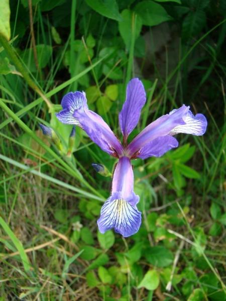
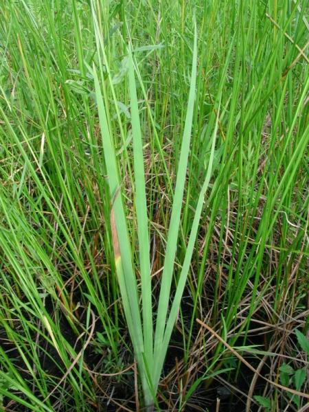
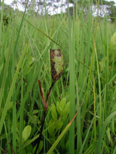
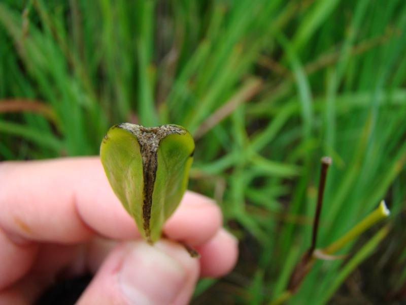
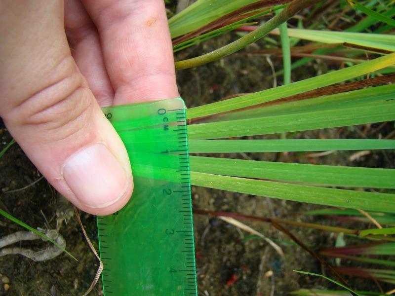
Slender Blue Flag is a perennial herb species growing from 30 to 80 centimeters tall from cordlike roots. The leaves are grasslike, erect, and 2 to 5 millimeters wide, with a central rib. The infloresence of 1 to 3 flowers is held on an erect, simple or slightly branched stem. The flowers are large (4-5 centimeters wide), the 3 sepals pale violet with yellow patches near the base and 3 lavender petals. The sepals also have small (5-7 millimeter), toothed, purple appendages called crests emerging from their bases opposite the yellow patches. The fruits are 3-sided capsules 3 to 4 centimeters long, containing one row of seeds per locule (FNA 2002).
Best Life Stage for Proper Identification
Iris prismatica may be identified in vegetative form, but more easily so when in flower or fruit.
Similar Species
The most common tall, violet-flowered Iris in New York, Iris versicolor, has leaves one to three centimeters wide. The only other tall, violet flowered Iris i with narrow leaves n New York is I. sibirica. It differs from Iris primatica by having hollow stems, flowers with white patches at the base of the sepals, and fruits with two rows of seeds per locule (FNA 2002).
Best Time to See
Iris prismatica flowers from June through July, and remnant fruit stalks may persist year round.
- Vegetative
- Flowering
- Fruiting
The time of year you would expect to find Slender Blue Flag vegetative, flowering, and fruiting in New York.
Slender Blue Flag Images
Kimberly J. Smith
Stephen M. Young
Stephen M. Young
Stephen M. Young
Kimberly J. Smith
Kimberly J. Smith
Taxonomy
Slender Blue Flag
Iris prismatica Pursh ex Ker-Gawl.
- Kingdom Plantae
- Phylum Anthophyta
- Class Monocotyledoneae
(Monocots)
- Order Liliales
- Family Iridaceae (Iris Family)
- Order Liliales
- Class Monocotyledoneae
(Monocots)
- Phylum Anthophyta
Additional Common Names
- Coastal Iris
Additional Resources
Best Identification Reference
Gleason, Henry A. and A. Cronquist. 1991. Manual of Vascular Plants of Northeastern United States and Adjacent Canada. The New York Botanical Garden, Bronx, New York. 910 pp.
Other References
Clemants, Steven and Carol Gracie. 2006. Wildflowers in the Field and Forest. A Field Guide to the Northeastern United States. Oxford University Press, New York, NY. 445 pp.
Fernald, M.L. 1950. Gray's manual of botany. 8th edition. D. Van Nostrand, New York. 1632 pp.
Flora of North America Editorial Committee. 2002. Flora of North America, North of Mexico. Volume 26. Magnoliophyta: Liliidae: Liliales and Orchidales. Oxford University Press, New York. 723 pp.
Holmgren, Noel. 1998. The Illustrated Companion to Gleason and Cronquist's Manual. Illustrations of the Vascular Plants of Northeastern United States and Adjacent Canada. The New York Botanical Garden, Bronx, New York.
New York Natural Heritage Program. 2010. Biotics database. New York Natural Heritage Program. New York State Department of Environmental Conservation. Albany, NY.
New York Natural Heritage Program. 2024. New York Natural Heritage Program Databases. Albany, NY.
Newcomb, Lawrence. 1977. Newcomb's Wildflower Guide: An Ingenious New Key System for Quick, Positive Field Identification of the Wildflowers, Flowering Shrubs, and Vines of Northeastern and North-Central North America. Little, Brown and Company. Boston.
Weldy, T. and D. Werier. 2010. New York flora atlas. [S.M. Landry, K.N. Campbell, and L.D. Mabe (original application development), Florida Center for Community Design and Research http://www.fccdr.usf.edu/. University of South Florida http://www.usf.edu/]. New York Flora Association http://newyork.plantatlas.usf.edu/, Albany, New York
Links
About This Guide
Information for this guide was last updated on: November 17, 2011
Please cite this page as:
New York Natural Heritage Program. 2024.
Online Conservation Guide for
Iris prismatica.
Available from: https://guides.nynhp.org/slender-blue-flag/.
Accessed July 26, 2024.