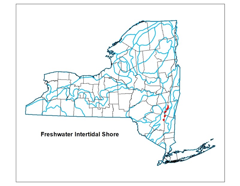
Freshwater Intertidal Shore
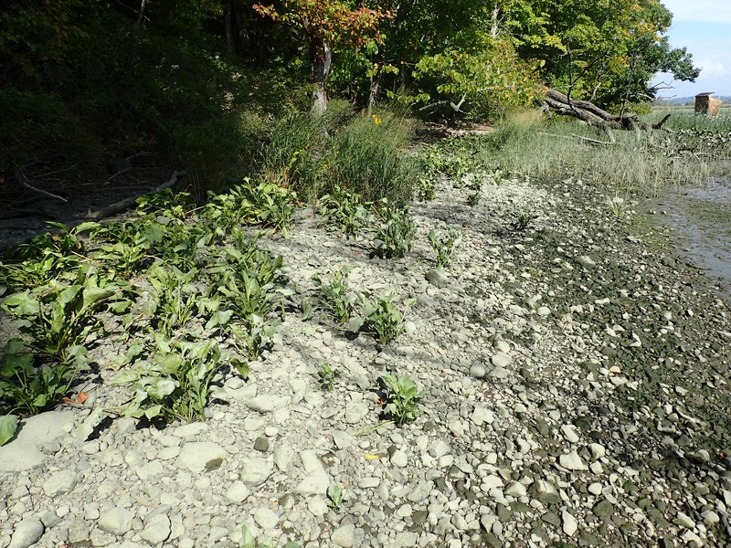
Freshwater intertidal shore at Brandow Point.
Gregory J. Edinger
- System
- Estuarine
- Subsystem
- Estuarine Intertidal
- State Protection
- Not Listed
Not listed or protected by New York State.
- Federal Protection
- Not Listed
- State Conservation Status Rank
- S2
Imperiled in New York - Very vulnerable to disappearing from New York due to rarity or other factors; typically 6 to 20 populations or locations in New York, very few individuals, very restricted range, few remaining acres (or miles of stream), and/or steep declines.
- Global Conservation Status Rank
- G3G4
Vulnerable globally, or Apparently Secure - At moderate risk of extinction, with relatively few populations or locations in the world, few individuals, and/or restricted range; or uncommon but not rare globally; may be rare in some parts of its range; possibly some cause for long-term concern due to declines or other factors. More information is needed to assign either G3 or G4.
Summary
Did you know?
Bank erosion along freshwater intertidal shores can increase sedimentation and turbidity, which decreases the light availabilty to underwater plants and animals. Placing hard structures like bulkheads or rip-rap along developed shorelines to prevent erosion can destroy wetlands and actually increase erosion on adjacent shorelines. While these structures may be necessary along high energy shorelines, alternatives such as marsh restoration are effective, less expensive options. Retaining or restoring marshes lessens the effects of erosion, reduces pollutants entering the water, enhances fisheries near the property, and creates a more attractive setting.
State Ranking Justification
There are estimated to be less than 40 occurrences in the state, and probably not many more in the northeast. This small, narrow-band community is restricted to the freshwater portion of tidal rivers where the substrate is rocky or gravelly. There are less than 10 occcurrences currently documented by New York Natural Heritage and they are limited to Columbia, Green, Dutchess, and Ulster Counties. Given their location at the tidal-upland interface, several of these occurrences are threatened by shoreline development and invasive plants.
Short-term Trends
The number of freshwater intertidal shores in New York have probably remained stable in recent decades. However, the condition and size of a few occurrences may have declined due to invasive species, such as purple loosestrife (Lythrum salicaria) and reed grass (Phragmites australis ssp. australis).
Long-term Trends
The number of freshwater intertidal shores in New York probably declined substantially from historical numbers as a result of shoreline development (e.g., railroads) and river channel dredging.
Conservation and Management
Threats
The main threats to this community are shoreline development (e.g., railroad tracks that impede or alter tidal flow, boat landings, artificial shoreline construction), and invasion of exotic species, such as purple loosestrife (Lythrum salicaria) and reed grass (Phragmites australis ssp. australis). Recreational overuse is a lesser threat (e.g., trampling of shore vegetation, mowing recreational areas, campsites, trash). Run-off from developed upland areas is another minor threat. Dredging of shipping lanes may also pose a threat by reducing water quality, or reducing area due to depositon of dredge spoils.
Conservation Strategies and Management Practices
Maintain tidal regime of shores cut off from the Hudson River by the railroad tracks. Control and remove invasive exotic species, such as purple loosestrife (Lythrum salicaria) and reed grass (Phragmites australis ssp. australis).
Development and Mitigation Considerations
Buffers that diminish or eliminate disturbances in this estuarine community are critical considerations for any development project. Such disturbances include the influx of water-borne solutes (road salt, fertilizers, herbicides, pesticides, sewage), water-borne sediments, and noise pollution. Strive to minimize or eliminate artificial shorelines that replace natural freshwater intertidal shores. Maintain high connectivity between the river and bays with shores to encourage full tidal flushing during each cycle of the tides. For example, barriers such as railway causeways should have numerous culverts to allow sufficient hydrologic connectivity.
Inventory Needs
Review data collected by partner organizations and incorporate this information into the New York Natural Heritage database. Resurvey and update occurrences with records greater than 10 years old.
Research Needs
Research the effects of invasive exotic plants on freshwater intertidal shores.
Rare Species
- Ardea herodias (Great Blue Heron) (guide)
- Bidens bidentoides (Estuary Beggar Ticks) (guide)
- Cardamine longii (Long's Bittercress) (guide)
- Crassula aquatica (Water Pigmyweed) (guide)
- Eleocharis engelmannii (Engelmann's Spike Rush) (guide)
- Eriocaulon parkeri (Estuary Hatpins) (guide)
- Orontium aquaticum (Golden Club) (guide)
- Plantago cordata (Heart-leaved Plantain) (guide)
- Rallus elegans (King Rail) (guide)
- Rorippa aquatica (Lake Water Cress) (guide)
Range
New York State Distribution
This community is currently restricted to the central Hudson Valley portion of the Hudson River, ranging from Rensselaer County to Rockland County, with most occurring in Columbia, Green, Dutchess, and Ulster Counties.
Global Distribution
Freshwater intertidal shores occur along tidal rivers from New York to North Carolina where rocky and gravelly substrates are present.
Best Places to See
- Hudson River National Estuarine Research Reserve
- Tivoli Bay Wildlife Management Area
- Lewis A. Swyer Preserve
Identification Comments
General Description
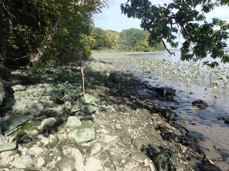
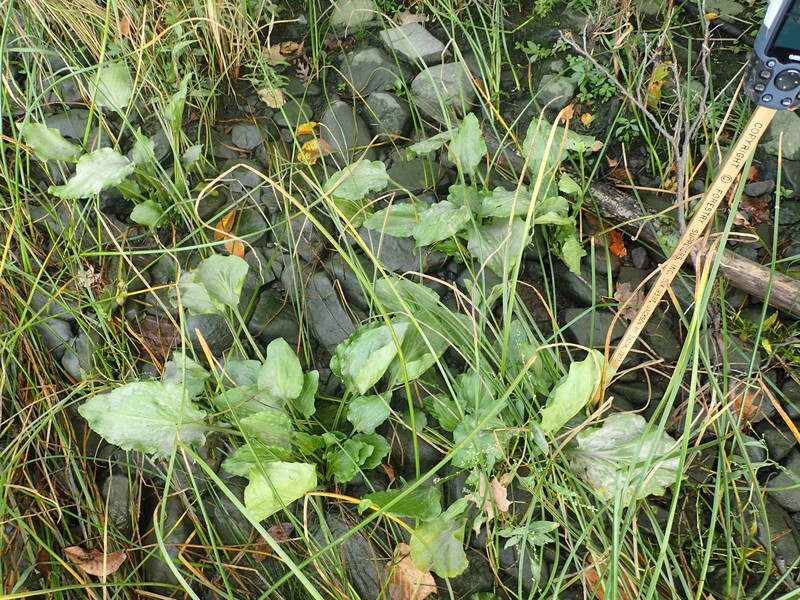
Freshwater intertidal shore communities occur on the intertidal gravelly or rocky shores of freshwater tidal rivers and creeks, and sometimes at the base of cliffs. The water salinity values are below 0.5 parts per thousand (ppt). The vegetation may be sparse, and may include heart-leaved plantain (Plantago cordata), water-hemp (Amaranthus cannabis), switchgrass (Panicum virgatum), golden club (Orontium aquaticum), clammy hedge-hyssop (Gratiola neglecta), beggar-ticks (Bidens spp.), and cardinal flower (Lobelia cardinalis).
Characters Most Useful for Identification
A community of intertidal gravelly or rocky shores of freshwater tidal rivers and creeks, sometimes occurring at the base of cliffs. The water salinity values are below 0.5 ppt. The vegetation may be sparse, and is characterized by wetland herbaceous species.
Elevation Range
Known examples of this community have been found at elevations between -1 feet and 20 feet.
Best Time to See
Throughout the growing season, from spring to late summer, wildflowers characteristic of freshwater intertidal shores come into bloom. These include golden club, clammy hedge-hyssop, beggar-ticks, and the brilliant cardinal flower.
Freshwater Intertidal Shore Images
Gregory J. Edinger
Gregory J. Edinger
Gregory J. Edinger
Classification
Characteristic Species
-
Trees > 5m
- Celtis occidentalis (northern hackberry)
-
Shrubs 2 - 5m
- Amorpha fruticosa (false indigo-bush)
- Physocarpus opulifolius (ninebark)
-
Herbs
- Amaranthus cannabinus (salt marsh water-hemp)
- Ambrosia trifida (giant ragweed)
- Bidens bidentoides (estuary beggar-ticks)
- Bidens frondosa (devil's beggar-ticks)
- Cardamine pensylvanica (Pennsylvania bitter cress)
- Eleocharis spp.
- Eutrochium maculatum var. maculatum (spotted Joe-Pye-weed)
- Helenium autumnale (common sneezeweed)
- Impatiens capensis (spotted jewelweed, spotted touch-me-not)
- Iris pseudacorus (yellow iris)
- Lobelia cardinalis (cardinal flower)
- Lythrum salicaria (purple loosestrife)
- Panicum virgatum (switch grass)
- Persicaria hydropiperoides (mild water-pepper)
- Pilea fontana (black-fruited clearweed)
- Plantago cordata (heart-leaved plantain)
- Schoenoplectus americanus (chair-maker's bulrush)
- Schoenoplectus tabernaemontani (soft-stemmed bulrush)
- Typha latifolia (wide-leaved cat-tail)
-
Emergent aquatics
- Orontium aquaticum (golden-club)
- Pontederia cordata (pickerelweed)
Similar Ecological Communities
- Brackish intertidal shore
Brackish intertidal shore communities occur along intertidal rocky or gravelly shores, but unlike freshwater intertidal shores, they have water salinity values between 0.5 to 18 ppt, and are made up of plant species that are adapted to these salt levels.
- Freshwater intertidal mudflats
(guide)
Freshwater intertidal shore communities occur along intertidal rocky or gravelly shores, rather than on intertidal mudflats. In addition, freshwater intertidal mudflat communities have a different plant species composition than freshwater intertidal shore communities, including short-growing rosette-leaved aquatics.
- Freshwater tidal marsh
(guide)
Freshwater tidal marshes occur in shallow bays, or at the mouth of tributaries within large tidal river systems, rather than along shorelines.
- Riverside sand/gravel bar
(guide)
Riverside sand/gravel bars may have the same substrate as freshwater intertidal shores, but are restricted to non-tidal areas of rivers.
Vegetation
Percent cover
This figure helps visualize the structure and "look" or "feel" of a typical Freshwater Intertidal Shore. Each bar represents the amount of "coverage" for all the species growing at that height. Because layers overlap (shrubs may grow under trees, for example), the shaded regions can add up to more than 100%.
Additional Resources
References
DeVries, C. and C.B. DeWitt. 1986. Freshwater tidal wetlands community description and relation of plant distribution to elevation and substrate. In: Polgar Fellowship Reports of the Hudson River National Estuarine Sanctuary Program 1986. E.A. Blair and J.C. Cooper, editors. Hudson River Foundation, New York, New York.
Edinger, G. J., D. J. Evans, S. Gebauer, T. G. Howard, D. M. Hunt, and A. M. Olivero (editors). 2014. Ecological Communities of New York State. Second Edition. A revised and expanded edition of Carol Reschke’s Ecological Communities of New York State. New York Natural Heritage Program, New York State Department of Environmental Conservation, Albany, NY. https://www.nynhp.org/ecological-communities/
Edinger, Gregory J., D.J. Evans, Shane Gebauer, Timothy G. Howard, David M. Hunt, and Adele M. Olivero (editors). 2002. Ecological Communities of New York State. Second Edition. A revised and expanded edition of Carol Reschke's Ecological Communities of New York State. (Draft for review). New York Natural Heritage Program, New York State Department of Environmental Conservation. Albany, NY. 136 pp.
Findlay, S.E.G., E. Kiviat, W.C. Nieder, and E.A. Blair. 2002. Functional assessment of a reference wetland set as a tool for science, management and restoration. Aquat. Sci. 64:107-117.
Kiviat, E. 1974. A fresh-water tidal marsh on the Hudson, Tivoli North Bay. Paper 14, In Third Symposium on Hudson River Ecology, Hudson River Environmental Society, Bronx, New York.
Kiviat, E. 1979. Hudson River Estuary shore zone: ecology and management. MA Thesis, State University College, New Paltz, New York.
Kiviat, Erik and Gretchen Stevens. 2001. Biodiversity assessment manual for the Hudson River Estuary Corridor. New York State Department of Environmental Conservation. Albany, NY.
Muenscher, W.C. 1937. VII. Aquatic vegetation of the Lower Hudson area. 1936. Biological Survey. 11:231-248.
New York Natural Heritage Program. 2024. New York Natural Heritage Program Databases. Albany, NY.
Reschke, Carol. 1990. Ecological communities of New York State. New York Natural Heritage Program, New York State Department of Environmental Conservation. Latham, NY. 96 pp. plus xi.
Links
About This Guide
This guide was authored by: Gregory J. Edinger
Information for this guide was last updated on: January 18, 2024
Please cite this page as:
New York Natural Heritage Program. 2024.
Online Conservation Guide for
Freshwater intertidal shore.
Available from: https://guides.nynhp.org/freshwater-intertidal-shore/.
Accessed July 26, 2024.