Freshwater Intertidal Mudflats
Freshwater intertidal mudflats
Stephen M. Young
- System
- Estuarine
- Subsystem
- Estuarine Intertidal
- State Protection
- Not Listed
Not listed or protected by New York State.
- Federal Protection
- Not Listed
- State Conservation Status Rank
- S2
Imperiled in New York - Very vulnerable to disappearing from New York due to rarity or other factors; typically 6 to 20 populations or locations in New York, very few individuals, very restricted range, few remaining acres (or miles of stream), and/or steep declines.
- Global Conservation Status Rank
- G3G4
Vulnerable globally, or Apparently Secure - At moderate risk of extinction, with relatively few populations or locations in the world, few individuals, and/or restricted range; or uncommon but not rare globally; may be rare in some parts of its range; possibly some cause for long-term concern due to declines or other factors. More information is needed to assign either G3 or G4.
Summary
Did you know?
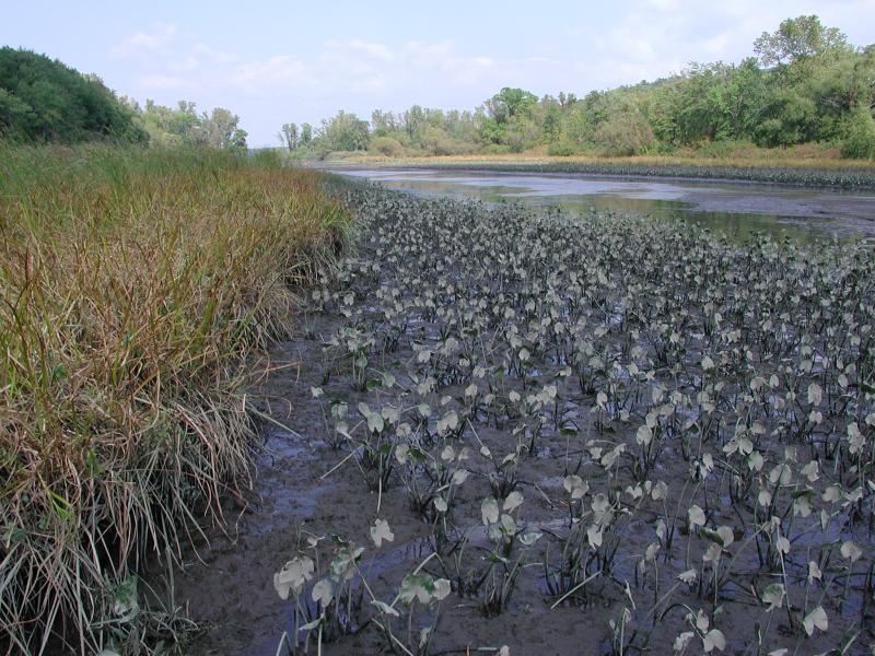
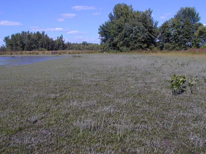
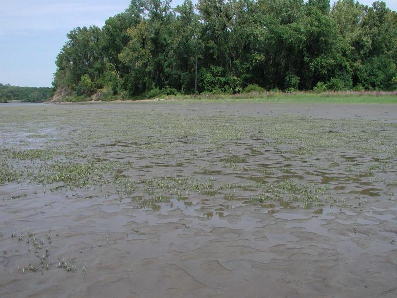
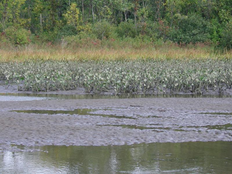
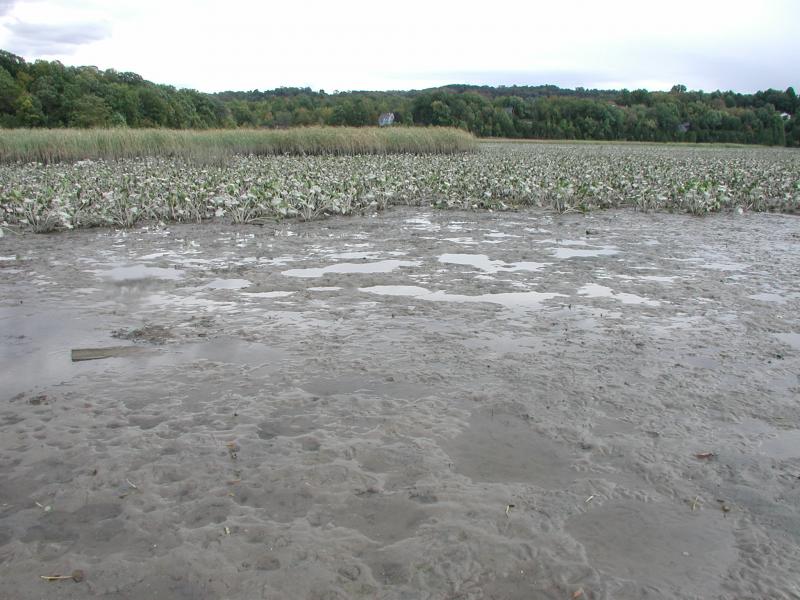
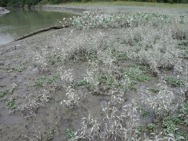
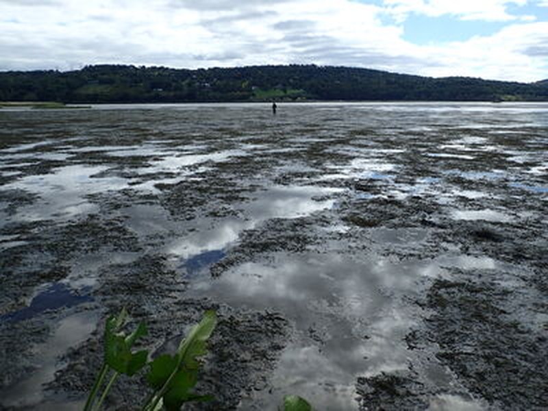
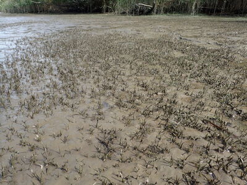
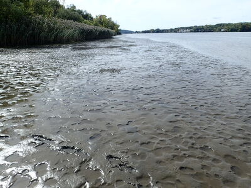
Freshwater intertidal mudflats are characterized by low-growing rosette-leaved aquatics that are adapted to the tides that flush the community daily. At low tide, the community and rosette-leaved plants are exposed. At high tide, they are completely submerged in three to four feet of water.
State Ranking Justification
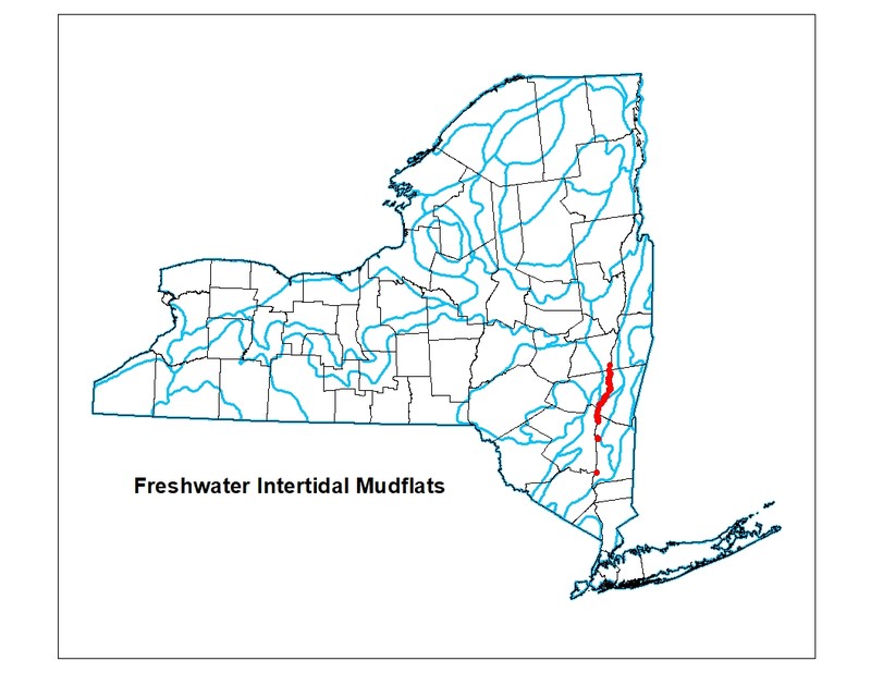
This community is restricted to the freshwater portion of tidal rivers. All occurrences are on the Hudson River with about 90% in Greene, Columbia, and Dutchess Counties. There are estimated to be less than 100 occurrences in the state. Several of these occurrences are threatened because of shoreline development, invasive plants, and river channel dredging.
Short-term Trends
The number of freshwater intertidal mudflats in New York have probably remained stable in recent decades as a result of wetland protection regulations.
Long-term Trends
The number of freshwater intertidal mudflats in New York have probably substantially declined (about 80%) from historical numbers likely correlated with shoreline development and river channel dredging.
Conservation and Management
Threats
The main threats to this community are shoreline development (including railroad tracks), and invasion of exotic species, such as water chestnut (Trapa natans). Recreational boat traffic that scrapes across the mudflats at high tides, and ATV and motorcycle use at low tide cause direct degradation. Dredging of shipping lanes may also pose a threat by reducing water quality and altering natural tidal regime and sediment deposition.
Conservation Strategies and Management Practices
Maintain tidal regime in marshes cut off from the Hudson River near the railroad tracks.
Development and Mitigation Considerations
Buffers that diminish or eliminate disturbances in this estuarine community are critical considerations for any development project. Such disturbances include the influx of water-borne solutes (road salt, fertilizers, herbicides, pesticides, sewage), water-borne sediments, and noise pollution. Strive to minimize or eliminate hardened shorelines and maintain very low-sloped shorelines within the tidal zone. Maintain high connectivity between the river and the mudflat to encourage full tidal flushing during each cycle of the tides. For example, barriers such as railway causeways should have numerous culverts to allow sufficient hydrologic connectivity.
Inventory Needs
Survey areas adjacent to known freshwater tidal marshes and freshwater subtidal aquatic beds for more examples of intertidal mudflats. Search for additional sites on Long Island.
Research Needs
Collect sufficient plot data to describe variants based on topgraphic setting (e.g., large flats in open river, enclosed basins, adjacent to islands, along freshwater tidal creeks, etc.).
Rare Species
- Ardea herodias (Great Blue Heron) (guide)
- Bidens bidentoides (Estuary Beggar Ticks) (guide)
- Bidens hyperborea var. hyperborea (Estuary Beggar-ticks) (guide)
- Bidens laevis (Smooth Beggar Ticks) (guide)
- Callitriche terrestris (Terrestrial Water Starwort) (guide)
- Cardamine longii (Long's Bittercress) (guide)
- Crassula aquatica (Water Pigmyweed) (guide)
- Elatine americana (American Waterwort) (guide)
- Eleocharis aestuum (Intertidal Spike Rush) (guide)
- Eriocaulon parkeri (Estuary Hatpins) (guide)
- Isoetes riparia (Riverbank Quillwort) (guide)
- Juncus subcaudatus (Spreading Rush) (guide)
- Orontium aquaticum (Golden Club) (guide)
- Plantago cordata (Heart-leaved Plantain) (guide)
- Rallus elegans (King Rail) (guide)
- Sagittaria montevidensis ssp. spongiosa (Spongy-leaved Arrowhead) (guide)
- Stylurus plagiatus (Russet-tipped Clubtail) (guide)
Range
New York State Distribution
This community is currently restricted to the central Hudson Valley portion of the Hudson River, ranging from Albany to Poughkeepsie, with most examples occurring in Columbia and Greene Counties. Small examples of freshwater intertidal mudflats may also occur along tidal rivers on Long Island.
Global Distribution
Freshwater intertidal mudflats occur along tidal rivers from New York to North Carolina.
Best Places to See
- Bristol Beach State Park (Ulster County)
- Lewis A. Swyer Preserve
- Hudson River National Estuarine River Research Preserve
- Tivoli Bay Wildlife Management Area
- Rogers Island Wildlife Management Area
Identification Comments
General Description
A sparsely vegetated community characterized by low-growing rosette-leaved aquatics. This community occurs on exposed intertidal mudflats where the water is fresh, with salinity values below 0.5 parts per thousand (ppt). This community is best developed where mudflats are nearly level so that broad expanses are exposed at low tide. The plants are completely submerged in 0.9 to 1.2 m (3-4 feet) of water at high tide, and they are usually coated with mud.
Characters Most Useful for Identification
Sparsely vegetated mudflats along tidal rivers that are exposed at low tide.
Elevation Range
Known examples of this community have been found at elevations between -1 feet and 20 feet.
Best Time to See
Freshwater intertidal mudflats are best observed at low tide. The characteristic rosette-leaved plants of this community are generally at their peak from mid-July through August.
Freshwater Intertidal Mudflats Images
Stephen M. Young
Troy Weldy
Timothy G. Howard
Timothy G. Howard
Stephen M. Young
Timothy G. Howard
Timothy G. Howard
Tim Howard
Gregory J. Edinger
Gregory J. Edinger
Gregory J. Edinger
Classification
International Vegetation Classification Associations
This New York natural community encompasses all or part of the concept of the following International Vegetation Classification (IVC) natural community associations. These are often described at finer resolution than New York's natural communities. The IVC is developed and maintained by NatureServe.
- Awl-leaf Arrowhead - Welsh Mudwort Tidal Marsh (CEGL004473)
NatureServe Ecological Systems
This New York natural community falls into the following ecological system(s). Ecological systems are often described at a coarser resolution than New York's natural communities and tend to represent clusters of associations found in similar environments. The ecological systems project is developed and maintained by NatureServe.
- Atlantic Coastal Plain Embayed Region Tidal Freshwater Marsh (CES203.259)
Characteristic Species
-
Herbs
- Heteranthera reniformis (mud-plantain)
- Nuphar advena
- Orontium aquaticum (golden-club)
- Peltandra virginica (green arrow-arum, tuckahoe)
- Persicaria hydropiperoides (mild water-pepper)
- Pontederia cordata (pickerelweed)
- Sagittaria graminea ssp. graminea (grass-leaved arrowhead)
- Sagittaria montevidensis ssp. spongiosa (spongy-leaved arrowhead)
- Sagittaria rigida (sessile-fruited arrowhead)
- Sagittaria subulata (awl-leaved arrowhead)
- Schoenoplectus americanus (chair-maker's bulrush)
Similar Ecological Communities
- Brackish intertidal mudflats
(guide)
Brackish intertidal mudflats are slightly saltier (0.5 to 18.0 ppt) than freshwater intertidal mudflats (less than 0.5 ppt). Brackish intertidal mudflats are usually adjacent to brackish tidal marshes rather than freshwater tidal marshes.
- Freshwater tidal marsh
(guide)
Freshwater tidal marshes are dominated by plants that rise above the water at high tide. Freshwater intertidal mudflats have plants that are submerged at high tide.
- Riverside sand/gravel bar
(guide)
Riverside sand/gravel bars have different characteristic plant species and are not tidally influenced.
Vegetation
Percent cover
This figure helps visualize the structure and "look" or "feel" of a typical Freshwater Intertidal Mudflats. Each bar represents the amount of "coverage" for all the species growing at that height. Because layers overlap (shrubs may grow under trees, for example), the shaded regions can add up to more than 100%.
Additional Resources
References
DeVries, C. and C.B. DeWitt. 1986. Freshwater tidal wetlands community description and relation of plant distribution to elevation and substrate. In: Polgar Fellowship Reports of the Hudson River National Estuarine Sanctuary Program 1986. E.A. Blair and J.C. Cooper, editors. Hudson River Foundation, New York, New York.
Edinger, G. J., D. J. Evans, S. Gebauer, T. G. Howard, D. M. Hunt, and A. M. Olivero (editors). 2014. Ecological Communities of New York State. Second Edition. A revised and expanded edition of Carol Reschke’s Ecological Communities of New York State. New York Natural Heritage Program, New York State Department of Environmental Conservation, Albany, NY. https://www.nynhp.org/ecological-communities/
Edinger, Gregory J., D.J. Evans, Shane Gebauer, Timothy G. Howard, David M. Hunt, and Adele M. Olivero (editors). 2002. Ecological Communities of New York State. Second Edition. A revised and expanded edition of Carol Reschke's Ecological Communities of New York State. (Draft for review). New York Natural Heritage Program, New York State Department of Environmental Conservation. Albany, NY. 136 pp.
Findlay, S.E.G., E. Kiviat, W.C. Nieder, and E.A. Blair. 2002. Functional assessment of a reference wetland set as a tool for science, management and restoration. Aquat. Sci. 64:107-117.
Kiviat, E. 1974. A fresh-water tidal marsh on the Hudson, Tivoli North Bay. Paper 14, In Third Symposium on Hudson River Ecology, Hudson River Environmental Society, Bronx, New York.
Kiviat, E. 1979. Hudson River Estuary shore zone: ecology and management. MA Thesis, State University College, New Paltz, New York.
Kiviat, E. and E. Beecher. 1991. Vegetation in the fresh-tidal habitats of Tivoli Bays, Hudson River. Hudsonia Ltd., Bard College Field Station, Annandale, New York.
Kiviat, Erik and Gretchen Stevens. 2001. Biodiversity assessment manual for the Hudson River Estuary Corridor. New York State Department of Environmental Conservation. Albany, NY.
Metzler, K. and R. Rosza. 1982. Vegetation of fresh and brackish tidal marshes in Connecticut. Newsletter of the Connecticut Botanical Society 10(1): 1-3.
Muenscher, W.C. 1937. VII. Aquatic vegetation of the Lower Hudson area. 1936. Biological Survey. 11:231-248.
New York Natural Heritage Program. 2024. New York Natural Heritage Program Databases. Albany, NY.
Odum, W.E., T.J. Smith III, J.K. Hoover, and C.C McIvor. 1984. The ecology of tidal freshwater marshes of the United States east coast: A community profile. U.S. Fish and Wildlife Service, Washington, D.C. FWS/OBS-83/17.
Reschke, Carol. 1990. Ecological communities of New York State. New York Natural Heritage Program, New York State Department of Environmental Conservation. Latham, NY. 96 pp. plus xi.
Links
About This Guide
This guide was authored by: Timothy G. Howard
Information for this guide was last updated on: January 18, 2024
Please cite this page as:
New York Natural Heritage Program. 2024.
Online Conservation Guide for
Freshwater intertidal mudflats.
Available from: https://guides.nynhp.org/freshwater-intertidal-mudflats/.
Accessed July 26, 2024.