Marl Fen
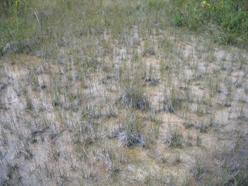
Marl fen at Lowery Pond.
Gregory J. Edinger
- System
- Palustrine
- Subsystem
- Open Peatlands
- State Protection
- Not Listed
Not listed or protected by New York State.
- Federal Protection
- Not Listed
- State Conservation Status Rank
- S1
Critically Imperiled in New York - Especially vulnerable to disappearing from New York due to extreme rarity or other factors; typically 5 or fewer populations or locations in New York, very few individuals, very restricted range, very few remaining acres (or miles of stream), and/or very steep declines.
- Global Conservation Status Rank
- G1
Critically Imperiled globally - At very high risk of extinction due to extreme rarity or other factors; typically 5 or fewer populations or locations in the world, very few individuals, very restricted range, very few remaining acres (or miles of stream), and/or very steep declines.
Summary
Did you know?
Marl fens occur where carbonates such as calcite and calcium or magnesium carbonate (marl), precipitate at the surface and plant root zone of a wetland. As ground water rich in these compounds flows upward to the wetland surface at high rates, decreases in the partial pressure of CO2 cause marl to precipate (Bedford and Godwin 2003)
State Ranking Justification
There are probably less than 10 occurrences statewide, and the total acreage is very small. A couple documented occurrences have good viability and are protected on public land or private conservation land. This community is limited to the calcareous areas of the state where marl deposits form on the surface. The current trend of this community is probably stable for occurrences on protected land, or declining slightly elsewhere due to moderate threats related to development pressure, invasive plants, and alteration to the natural hydrology.
Short-term Trends
The number and acreage of marl fens in New York have probably declined slightly in recent decades as a result of alteration of natural hydrolgy, invasive species, and development.
Long-term Trends
The number and acreage of marl fens in New York have probably declined moderately to substantially from historical numbers, likely correlated with the onset of agricultural and residential development.
Conservation and Management
Threats
Marl fens are threatened by development and its associated run-off (e.g., agriculture, residential, roads), recreational overuse (e.g., ATVs, hiking trails), and habitat alteration in the adjacent landscape (e.g., mining, excessive logging, pollution). Alteration to the natural hydrology (e.g., ditching, blocked culverts, beaver) is a threat to this community type. Marl fens are threatened by invasive species, such as reed grass (Phragmites australis ssp. australis) and purple loosestrife (Lythrum salicaria).
Conservation Strategies and Management Practices
Consider how water flows around and into this wetland. As most of the water inputs are from underground, management for the prevention of altered water quality and quantity is particularly difficult for this natural community, but also of utmost priority. Projects that occur near this community must consider the proximity of the development to this wetland and the potential for changing how water flows, both above ground and below ground, into this wetland. Concerning the proximity to the wetland, terrestrial buffers provide nesting habitat for resident salamanders, frogs, and turtles and additional food sources for locally nesting birds. Consultation with a hydrologist is important to determine patterns of runoff and underground water sources for the wetland; however, impervious surfaces that rapidly divert water to the wetland should be avoided. Rapid influxes of surface water dilute the limey, mineral rich waters, decrease the robustness of the native fen species, and increase the likelihood of invasion by non-native species.
Development and Mitigation Considerations
When considering road construction and other development activities, minimize actions that will change what water carries and how water travels to this community, both on the surface and underground. Water traveling over-the-ground as run-off usually carries an abundance of silt, clay, and other particulates during (and often after) a construction project. While still suspended in the water, these particulates make it difficult for aquatic animals to find food; after settling to the bottom of the wetland, these particulates bury small plants and animals and alter the natural functions of the community in many other ways. Thus, road construction and development activities near this community type should strive to minimize particulate-laden run-off into this community. Water traveling on the ground or seeping through the ground also carries dissolved minerals and chemicals. Road salt, for example, is becoming an increasing problem both to natural communities and as a contaminant in household wells. Fertilizers, detergents, and other chemicals that increase the nutrient levels in wetlands cause algae blooms and eventually an oxygen-depleted environment where few animals can live. Herbicides and pesticides often travel far from where they are applied and have lasting effects on the quality of the natural community. So, road construction and other development activities should strive to consider: 1. how water moves through the ground, 2. the types of dissolved substances these development activities may release, and 3. how to minimize the potential for these dissolved substances to reach this natural community.
Inventory Needs
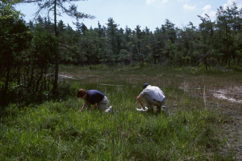
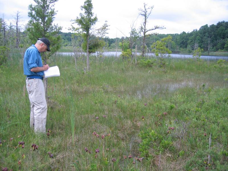
Inventory known examples of marl fen and survey undocumented fens adjacent to known occurrencs of marl pond and marl pond shore. Additional inventory efforts in regions with calcareous bedrock and promising wetlands will likely turn up a few additional sites. Resurveys of known sites will provide important information to help assess short and long term changes. Survey fens that provide habitat for rare species.
Research Needs
Research better ways to accurately and efficiently measure and understand the groundwater hydrology and what conditions are conducive for marl production in these fens. Further research into determining the proportion of fen water inputs is needed (e.g., groundwater vs. surface). If a fen is strongly groundwater influenced, traditional wetland buffers aimed at reducing surface water run-off may not sufficiently protect fen groundwater hydrology.
Rare Species
- Anticlea elegans var. glauca (White Death Camas) (guide)
- Carex buxbaumii (Brown Bog Sedge) (guide)
- Carex crawei (Crawe's Sedge) (guide)
- Carex meadii (Mead's Sedge) (guide)
- Carex sartwellii (Sartwell's Sedge) (guide)
- Cypripedium candidum (Small White Lady's Slipper) (guide)
- Eleocharis quinqueflora (Few-flowered Spike Rush) (guide)
- Glyptemys muhlenbergii (Bog Turtle) (guide)
- Juniperus horizontalis (Creeping Juniper) (guide)
- Panicum flexile (Wiry Witch Grass) (guide)
- Pedicularis lanceolata (Marsh Lousewort) (guide)
- Pycnanthemum verticillatum var. verticillatum (Whorled Mountain Mint) (guide)
- Regina septemvittata (Queen Snake) (guide)
- Scleria verticillata (Low Nut Sedge) (guide)
- Sistrurus catenatus (Eastern Massasauga) (guide)
- Solidago ohioensis (Ohio Goldenrod) (guide)
- Triantha glutinosa (Sticky False Asphodel) (guide)
- Trichophorum cespitosum ssp. cespitosum (Deer's Hair Club Sedge) (guide)
- Triglochin palustris (Marsh Arrow Grass) (guide)
- Valeriana uliginosa (Marsh Valerian) (guide)
- Viola nephrophylla (Northern Bog Violet) (guide)
Range
New York State Distribution
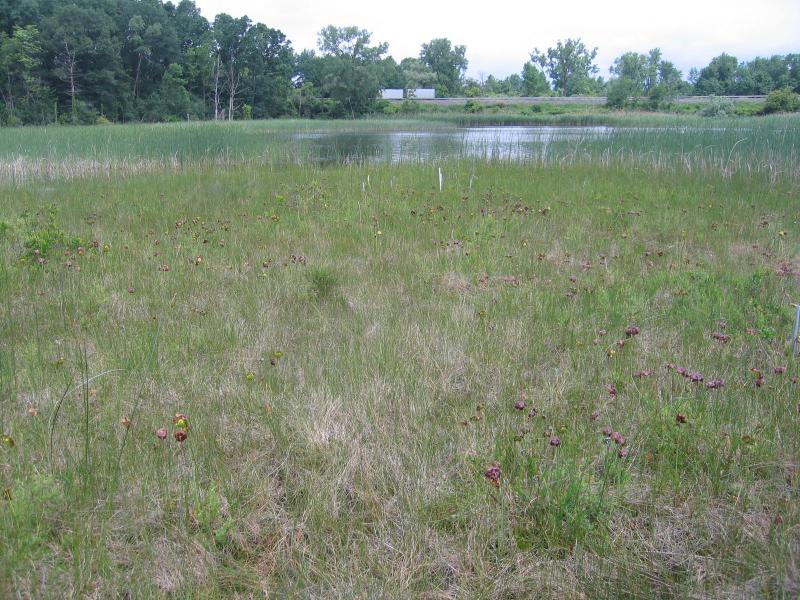
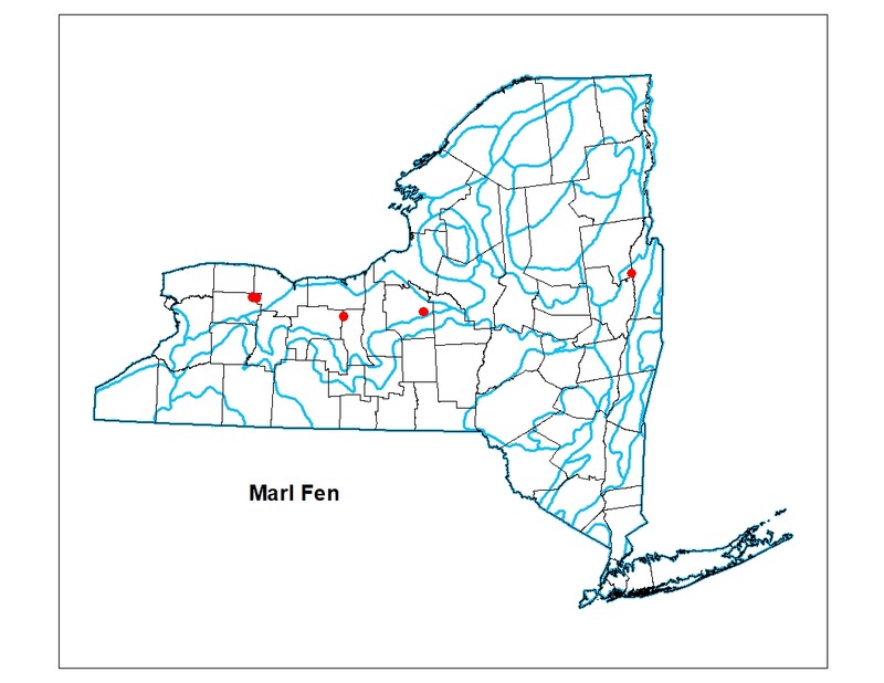
This community is restricted to a narrow zone roughly parallel to and north of the Onondaga escarpment in Genesee, Monroe, Seneca, Onondaga, and Warren counties. It is known from only 2-3 localities in New Jersey and 5 in New York, with very few potential additions. It is restricted to a precise habitat, seepage areas of thick marl deposits on the shores of calcareous lakes, ponds, and shallow basins.
Global Distribution
It is known from only 2-3 localities in New Jersey and 5 in New York, with very few potential additions. It is restricted to a precise habitat, seepage areas of thick marl deposits on the shores of calcareous lakes. Total acreage is less than 10 acres, a liberal estimate (NatureServe 2014).
Best Places to See
- Bergen Swamp Preserve (Genesee County)
- Junius Ponds Lowery Pond (Seneca County)
- White Lake Swamp Preserve (Onondaga County)
Identification Comments
General Description
A strongly minerotrophic wetland in which the substrate is a marl bed derived from either lacustrine marl deposits or actively accumulating marl that is exposed at the ground surface. Marl is a white-colored precipitate that consists of calcium carbonate mixed with clay. Marl fens have at least some exposed marl precipitate at the surface. The marl substrate is always saturated and may be either seasonally flooded or permanently flooded (e.g., adjacent to seepage pools or streams) and has a very high pH, generally greater than 7.5. Vegetation is often sparse and stunted. Mosses colonize the marl, and may initiate hummock formation (Seischab 1984), but marl fens have lower bryophyte diversity than other rich fen types (Slack 1994). Marl fens may occur as small patches within a rich graminoid fen.
Characters Most Useful for Identification
The dominant species in marl fens are graminoid. Characteristic herbaceous species include yellow sedge (Carex flava), spikerush (Eleocharis rostellata), twig-rush (Cladium mariscoides), beakrush (Rhynchospora capillacea), water-horehound (Lycopus uniflorus), grass-of-Parnassus (Parnassia glauca), pitcher-plant (Sarracenia purpurea), hard-stem bulrush (Schoenoplectus acutus), nutrush (Scleria verticillata), Ohio goldenrod (Oligoneuron ohioense), arrow-grass (Triglochin maritimum), variegated horsetail (Equisetum variegatum), jointed rush (Juncus articulatus), and Kalm's lobelia (Lobelia kalmii). Shrubs found in marl fens include prostrate juniper (Juniperus horizontalis), shrubby cinquefoil (Dasiphora fruticosa ssp. floribunda), and northern white cedar (Thuja occidentalis). Shrubby cinquefoil and bristleleaf sedge (Carex eburnea) commonly occur on hummocks. Characteristic nonvascular species include common stonewort (Chara vulgaris) and the thallose liverwort Preissia quadrata. Common stonewort occurs in marl pools and along stream banks. Bryophyte species can also include the mosses Scorpidium revolvens, Campylium stellatum, Aulacomnium palustre, Bryum pseudotriquetrum, Calliergon giganteum, Calliergonella cuspidata, Cratoneuron filicinum, Scorpidium scorpioides, the thalloid liverwort Aneura pinguis, and the leafy liverwort Plagiochila porelloides.
Elevation Range
Known examples of this community have been found at elevations between 320 feet and 474 feet.
Best Time to See
Mid- to late summer is the best time to see the marl deposits forming on the fen surface.
Marl Fen Images
Gregory J. Edinger
Adele M. Olivero
Gregory J. Edinger
Gregory J. Edinger
Classification
International Vegetation Classification Associations
This New York natural community encompasses all or part of the concept of the following International Vegetation Classification (IVC) natural community associations. These are often described at finer resolution than New York's natural communities. The IVC is developed and maintained by NatureServe.
- Shrubby-cinquefoil / Needle Beaksedge - Low Nutrush Fen (CEGL006356)
NatureServe Ecological Systems
This New York natural community falls into the following ecological system(s). Ecological systems are often described at a coarser resolution than New York's natural communities and tend to represent clusters of associations found in similar environments. The ecological systems project is developed and maintained by NatureServe.
- Laurentian-Acadian Lakeshore Beach (CES201.586)
Characteristic Species
-
Shrubs < 2m
- Dasiphora fruticosa (shrubby-cinquefoil)
- Juniperus horizontalis (creeping juniper)
-
Herbs
- Carex flava (yellow sedge)
- Eleocharis rostellata (walking spike-rush)
- Parnassia glauca (common grass-of-Parnassus)
- Rhynchospora capillacea (hair beak sedge)
- Schoenoplectus acutus var. acutus (hard-stemmed bulrush)
- Scleria verticillata (low nut sedge)
- Triglochin palustris (marsh arrow-grass)
-
Submerged aquatics
- Chara vulgaris
Similar Ecological Communities
- Marl pond
(guide)
Marl ponds are small, shallow, spring-fed aquatic communities with calcium carbonate deposited on its substrate forming a marl sediment.
- Marl pond shore
(guide)
Marl pond shores are sparsely vegetated marly shores of an inland pond often with seasonally fluctuating water levels. They typically occur on inactive lacustrine marl deposits in kettleholes.
- Rich graminoid fen
(guide)
Rich graminoid fens are strongly minerotrophic herbaceous peatland in which the substrate lacks exposed marl precipiated at the surface. Rich graminoid fens support higher bryophyte diversity compared to marl fens.
Vegetation
Percent cover
This figure helps visualize the structure and "look" or "feel" of a typical Marl Fen. Each bar represents the amount of "coverage" for all the species growing at that height. Because layers overlap (shrubs may grow under trees, for example), the shaded regions can add up to more than 100%.
Additional Resources
References
Cowardin, L.M., V. Carter, F.C. Golet, and E.T. La Roe. 1979. Classification of wetlands and deepwater habitats of the United States. U.S. Fish and Wildlife Service. Washington, D.C. 131 pp.
Edinger, G. J., D. J. Evans, S. Gebauer, T. G. Howard, D. M. Hunt, and A. M. Olivero (editors). 2014. Ecological Communities of New York State. Second Edition. A revised and expanded edition of Carol Reschke’s Ecological Communities of New York State. New York Natural Heritage Program, New York State Department of Environmental Conservation, Albany, NY. https://www.nynhp.org/ecological-communities/
Edinger, Gregory J., D.J. Evans, Shane Gebauer, Timothy G. Howard, David M. Hunt, and Adele M. Olivero (editors). 2002. Ecological Communities of New York State. Second Edition. A revised and expanded edition of Carol Reschke's Ecological Communities of New York State. (Draft for review). New York Natural Heritage Program, New York State Department of Environmental Conservation. Albany, NY. 136 pp.
New York Natural Heritage Program. 2024. New York Natural Heritage Program Databases. Albany, NY.
New York State Department of Environmental Conservation. 1995. Freshwater Wetlands: Delineation Manual. July 1995. New York State Department of Environmental Conservation. Division of Fish, Wildlife, and Marine Resources. Bureau of Habitat. Albany, NY.
Olivero, A. M. 2001. Classification and mapping of New York's calcareous fen communities. New York Natural Heritage Program. Report prepared for The Nature Conservancy - Central/Western New York Chapter, Albany, NY. June 2001. 28 pp. plus appendices.
Reschke, Carol. 1990. Ecological communities of New York State. New York Natural Heritage Program, New York State Department of Environmental Conservation. Latham, NY. 96 pp. plus xi.
Seischab, F.K. 1984. Plant community development in the Byron-Bergen Swamp: Marl bed vegetation. Can. J. Bot. 62:1006-1017.
Slack, Nancy G. 1994. Can one tell the mire type from the bryophytes alone? J. Hattori Bot. Lab 75:149-159.
Links
About This Guide
This guide was authored by: Gregory J. Edinger
Information for this guide was last updated on: March 26, 2024
Please cite this page as:
New York Natural Heritage Program. 2024.
Online Conservation Guide for
Marl fen.
Available from: https://guides.nynhp.org/marl-fen/.
Accessed July 27, 2024.