Red Maple-Sweetgum Swamp
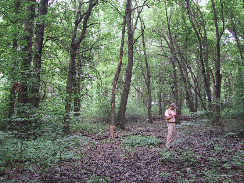
Ecologist in red maple-sweetgum swamp, Staten Island
Aissa L. Feldmann
- System
- Palustrine
- Subsystem
- Forested Mineral Soil Wetlands
- State Protection
- Not Listed
Not listed or protected by New York State.
- Federal Protection
- Not Listed
- State Conservation Status Rank
- S1
Critically Imperiled in New York - Especially vulnerable to disappearing from New York due to extreme rarity or other factors; typically 5 or fewer populations or locations in New York, very few individuals, very restricted range, very few remaining acres (or miles of stream), and/or very steep declines.
- Global Conservation Status Rank
- G4G5
Apparently or Demonstrably Secure globally - Uncommon to common in the world, but not rare; usually widespread, but may be rare in some parts of its range; possibly some cause for long-term concern due to declines or other factors. More information is needed to assign either G4 or G5.
Summary
Did you know?
Sweetgum (Liquidambar styraciflua) is aptly named - the resin from the tree was used as a chewing gum by several Native American tribes. The Cherokee, Choctaw, Koasati, and Rappahannock would knock a piece of bark from the sweetgum tree, causing resin to flow from the tree. The sap hardened after a week and was collected for chewing gum.
State Ranking Justification
There are an estimated 10 to 30 extant occurrences statewide. A few documented occurrences have good viability, but none of these are in excellent condition. A few are protected on public land or private conservation land. This community has a very limited statewide distribution that is primarily concentrated on Staten Island where there are several small, good quality examples. The current trend of this community is probably stable for occurrences on public land and private conservation land, or declining slightly elsewhere due to moderate threats that include alteration of the natural hydrology, development, and invasive species.
Short-term Trends
The number and acreage of red maple-sweetgum swamps in New York have probably declined slightly, or remained stable, in recent decades as a result of wetland protection regulations. Since World War II, urbanization has emerged as the predominant force impacting wetlands in most parts of the region (Golet et al. 1993).
Long-term Trends
The number and acreage of red maple-sweetgum swamps in New York have probably declined substantially from historical numbers likely correlated with agricultural and other development. The principal causes of wetland loss in the Northeast prior to mid-1800s include conversion of wetlands to agriculture, the construction of impoundments for hydropower and water supply, and the cutting of swamp timber for lumber, fence posts, and fuel wood (Golet et al. 1993). Extensive historical extirpation of red maple-sweetgum swamps has been cited by Stevens (1992). More wetlands are being drained and filled for development as undeveloped uplands in the metropolitan New York City area have become very scarce. Reportedly, no old-growth examples remain north of Richmond County (Stevens 1992).
Conservation and Management
Threats
Red maple-sweetgum swamps are threatened by development in the surrounding landscape and its assocaited run-off (e.g., residential, commercial, roads, utility ROWs, golf courses, etc.), habitat alteration (e.g., excessive logging, ditching, pollution), and recreational overuse (e.g., hiking trails, ATVs, trash dumping, illegal fires). Alteration to the natural hydrological regime is also a threat to this community (e.g., impoundments, blocked culverts). Several red maple-sweetgum swamps are threatened by invasive species, such as tree-of-heaven (Ailanthus altissima), barberry (Berberis thunbergii), Oriental bittersweet (Celastrus orbiculatus), Japanese honeysuckle (Lonicera japonica), multiflora rose (Rosa multiflora), garlic mustard (Alliaria petiolata), purple loosestrife (Lythrum salicaria), and reedgrass (Phragmites australis).Conversion of wetlands for agriculture was a major cause of inland wetland loss in many areas of the Northeast historically, and it is still an important factor today, most notably in New York (Golet et al. 1993).
Conservation Strategies and Management Practices
Where practical, establish and maintain a natural wetland buffer to reduce storm-water, pollution, and nutrient run-off, while simultaneously capturing sediments before they reach the wetland. Buffer width should take into account the erodibility of the surrounding soils, slope steepness, and current land use. Wetlands protected under Article 24 are known as New York State "regulated" wetlands. The regulated area includes the wetlands themselves, as well as a protective buffer or "adjacent area" extending 100 feet landward of the wetland boundary (NYS DEC 1995). If possible, minimize the number and size of impervious surfaces in the surrounding landscape. Avoid habitat alteration within the wetland and surrounding landscape. For example, roads and trails should be routed around wetlands, and should not pass through the buffer area. If the wetland must be crossed, then bridges and boardwalks are preferred over filling. Restore past impacts, such as removing obsolete impoundments and ditches in order to restore the natural hydrology. Prevent the spread of invasive exotic species into the wetland through appropriate direct management, and by minimizing potential dispersal corridors, such as roads.
Development and Mitigation Considerations
When considering road construction and other development activities minimize actions that will change what water carries and how water travels to this community, both on the surface and underground. Water traveling over-the-ground as run-off usually carries an abundance of silt, clay, and other particulates during (and often after) a construction project. While still suspended in the water, these particulates make it difficult for aquatic animals to find food; after settling to the bottom of the wetland, these particulates bury small plants and animals and alter the natural functions of the community in many other ways. Thus, road construction and development activities near this community type should strive to minimize particulate-laden run-off into this community. Water traveling on the ground or seeping through the ground also carries dissolved minerals and chemicals. Road salt, for example, is becoming an increasing problem both to natural communities and as a contaminant in household wells. Fertilizers, detergents, and other chemicals that increase the nutrient levels in wetlands cause algae blooms and eventually an oxygen-depleted environment where few animals can live. Herbicides and pesticides often travel far from where they are applied and have lasting effects on the quality of the natural community. So, road construction and other development activities should strive to consider: 1. how water moves through the ground, 2. the types of dissolved substances these development activities may release, and 3. how to minimize the potential for these dissolved substances to reach this natural community.
Inventory Needs
Continue searching for large sites in good condition (A- to AB-ranked).
Research Needs
Research the hydrologic regime of red maple-sweetgum swamps and determine what unique soil characteristics support this community. Assess examples (e.g., Arshamonaque) that are dominated by swamp white oak (Quercus bicolor), swamp cottonwood (Populus heterophylla), and pin oak (Quercus palustris) that have little or no red maple or sweetgum and determine if this is a new community type.
Rare Species
- Carex abscondita (Thicket Sedge) (guide)
- Carex collinsii (Collins' Sedge) (guide)
- Carex styloflexa (Bent Sedge) (guide)
- Euonymus americanus (American Strawberry Bush) (guide)
- Gentiana saponaria (Soapwort Gentian) (guide)
- Libellula flavida (Yellow-sided Skimmer) (guide)
- Magnolia virginiana (Sweetbay Magnolia) (guide)
- Pinus echinata (Short-leaved Pine) (guide)
- Populus heterophylla (Swamp Cottonwood) (guide)
- Protonotaria citrea (Prothonotary Warbler) (guide)
- Pycnanthemum muticum (Blunt Mountain Mint) (guide)
- Smilax pulverulenta (Powdery Carrion Flower) (guide)
- Viburnum nudum var. nudum (Southern Wild Raisin) (guide)
Range
New York State Distribution
This community is apparently concentrated in the western half of Staten Island (Richmond County) with a few examples extending north to the Hudson Highlands in Westchester and Rockland counties. Red maple-sweetgum swamps were probably historically present in very small patches farther east in Queens, Kings, and Nassau Counties. It was also likely to have been present historically in Bronx and New York Counties.
Global Distribution
The community range is centered in the Mid-Atlantic Coast Ecoregion, but extends into the North Atlantic Coast Ecoregion, and includes New York, New Jersey, Pennsylvania, Delaware, Maryland, Virginia, and possibly North Carolina. It may extend farther north along the coast of Connecticut (Bray 1915).
Best Places to See
- Clay Pit Ponds State Park Preserve (Richmond County)
- Tallman Mountain State Park (Rockland County)
Identification Comments
General Description
Sweetgum (Liquidambar styraciflua) is often the dominant tree or may be codominant with red maple (Acer rubrum). The shrub layer is usually fairly well-developed. Characteristic shrubs are sweet pepperbush (Clethra alnifolia), swamp azalea (Rhododendron viscosum), arrowwood (Viburnum dentatum var. lucidum), spicebush (Lindera benzoin), highbush blueberry (Vaccinium corymbosum), black chokeberry (Aronia melanocarpa) and possibly fetterbush (Leucothoe racemosa). The herbaceous layer is often dominated by ferns, including netted chain fern (Woodwardia areolata), cinnamon fern (Osmunda cinnamomea), and sensitive fern (Onoclea sensibilis). Characteristic herbs include lizard's-tail (Saururus cernuus), Canada mayflower (Maianthemum canadense), jumpseed (Persicaria virginiana), skunk cabbage (Symplocarpus foetidus) and jewelweed (Impatiens capensis).
Characters Most Useful for Identification
Red maple-sweetgum swamps occur on somewhat poorly drained seasonally wet flats, usually on somewhat acidic gleyed to mottled clay loam or sandy loam. Red maple-sweetgum swamps often occur as a mosaic with upland forest communities. Sweetgum (Liquidambar styraciflua) is often the dominant tree or may be codominant with red maple (Acer rubrum).
Elevation Range
Known examples of this community have been found at elevations between 8 feet and 190 feet.
Best Time to See
The community vegetation is at its peak during midsummer; at this time ferns, sedges, and herbs can be readily observed and identified. Striking seasonal leaf color can be enjoyed in the fall.
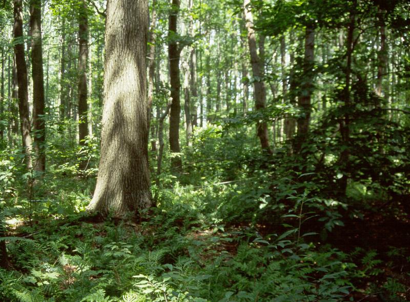
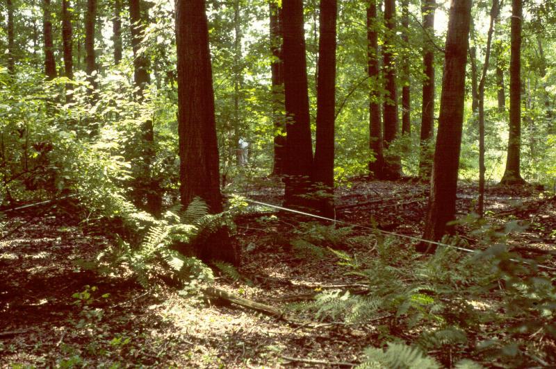
Red Maple-Sweetgum Swamp Images
Aissa L. Feldmann
Stephen M. Young
David M. Hunt
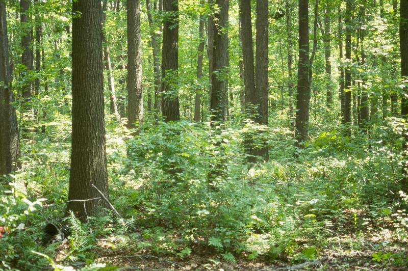
Stephen M. Young

Classification
International Vegetation Classification Associations
This New York natural community encompasses all or part of the concept of the following International Vegetation Classification (IVC) natural community associations. These are often described at finer resolution than New York's natural communities. The IVC is developed and maintained by NatureServe.
- Sweetgum - Red Maple - Willow Oak / Swamp Doghobble Swamp Forest (CEGL006110)
NatureServe Ecological Systems
This New York natural community falls into the following ecological system(s). Ecological systems are often described at a coarser resolution than New York's natural communities and tend to represent clusters of associations found in similar environments. The ecological systems project is developed and maintained by NatureServe.
- Northern Atlantic Coastal Plain Basin Swamp and Wet Hardwood Forest (CES203.520)
- Northern Atlantic Coastal Plain Pond (CES203.518)
Characteristic Species
-
Trees > 5m
- Acer rubrum var. rubrum (common red maple)
- Liquidambar styraciflua (sweet-gum)
- Nyssa sylvatica (black-gum, sour-gum)
- Populus heterophylla (swamp cottonwood)
- Quercus bicolor (swamp white oak)
- Quercus palustris (pin oak)
-
Shrubs 2 - 5m
- Aronia melanocarpa (black chokeberry)
- Clethra alnifolia (coastal sweet-pepperbush)
- Ilex verticillata (common winterberry)
- Lindera benzoin (spicebush)
- Ulmus americana (American elm)
- Viburnum dentatum var. lucidum (smooth arrowwood)
-
Shrubs < 2m
- Rhododendron viscosum (swamp azalea)
-
Vines
- Parthenocissus quinquefolia (Virginia-creeper)
- Smilax rotundifolia (common greenbrier)
- Toxicodendron radicans ssp. radicans (eastern poison-ivy)
-
Herbs
- Impatiens capensis (spotted jewelweed, spotted touch-me-not)
- Lorinseria areolata (netted chain fern)
- Onoclea sensibilis (sensitive fern)
- Osmundastrum cinnamomeum var. cinnamomeum (cinnamon fern)
- Polygonatum biflorum var. biflorum (small Solomon's-seal)
- Saururus cernuus (lizard's-tail)
- Symplocarpus foetidus (skunk-cabbage)
Similar Ecological Communities
- Hemlock-hardwood swamp
(guide)
Hemlock-hardwood swamps occur in poorly-drained basins, and have a high density of eastern hemlock (Tsuga canadensis) in the canopy. Sweetgum is not characteristic of hemlock-hardwood swamps.
- Perched swamp white oak swamp
(guide)
Perched swamp white oak swamps occur on hillsides in shallow depressions where the local water table is perched above the surrounding groundwater level. Swamp white oak is a canopy dominant in this community, whereas it is present in relatively low densities in red maple-sweetgum swamps.
- Red maple-blackgum swamp
(guide)
Red maple-blackgum swamps occur in poorly-drained basins, and have red maple and blackgum as canopy codominants; sweetgum, if present, is low in density.
- Red maple-hardwood swamp
(guide)
Red maple-hardwood swamps occur in poorly-drained basins, and have ash, elm, and birch are the characteristic codominants in red maple-hardwood swamps; sweetgum, if present, is low in density.
- Red maple-swamp white oak swamp
(guide)
While both swamps draw down in most years, swamp white oak is codominant in red maple-swamp white oak swamps and only a minor component in red maple-sweetgum swamps.
- Silver maple-ash swamp
(guide)
Silver maple-ash swamps are dominated by silver maple (Acer saccharinum) and green ash (Acer pennsylvanica); sweetgum is usually absent in this community.
Vegetation
Percent cover
This figure helps visualize the structure and "look" or "feel" of a typical Red Maple-Sweetgum Swamp. Each bar represents the amount of "coverage" for all the species growing at that height. Because layers overlap (shrubs may grow under trees, for example), the shaded regions can add up to more than 100%.
Additional Resources
References
Bray, W.L. 1915. The development of the vegetation of New York State. New York State College of Forestry, Tech. Publ. No. 3, Syracuse, NY.
Breden, T.F., Y. Alger, K. Strakosch Walz, and A.G. Windisch. 2001. Classification of Vegetation Communities of New Jersey: Second Iteration. Association for Biodiversity Information and New Jersey Natural Heritage Program, Office of Natural Lands Management, Division of Parks and Forestry, NJ Department of Environmental Protection. Trenton, NJ.
Edinger, G. J., D. J. Evans, S. Gebauer, T. G. Howard, D. M. Hunt, and A. M. Olivero (editors). 2014. Ecological Communities of New York State. Second Edition. A revised and expanded edition of Carol Reschke’s Ecological Communities of New York State. New York Natural Heritage Program, New York State Department of Environmental Conservation, Albany, NY. https://www.nynhp.org/ecological-communities/
Edinger, Gregory J., D.J. Evans, Shane Gebauer, Timothy G. Howard, David M. Hunt, and Adele M. Olivero (editors). 2002. Ecological Communities of New York State. Second Edition. A revised and expanded edition of Carol Reschke's Ecological Communities of New York State. (Draft for review). New York Natural Heritage Program, New York State Department of Environmental Conservation. Albany, NY. 136 pp.
Greller, A.M. 2000. Mixed hardwood swamp forest on rolling uplands near Lake Success on Long Island. The Quarterly Newsletter of the Long Island Botanical Society. 10(2):18-20.
Greller, Andrew M. 1977. A classification of mature forests on Long Island, New York. Bull. Torrey Bot. Club 140 (4):376-382.
Grossman, D. H., K. Lemon Goodin, and C. L. Reuss, editors. 1994. Rare plant communities of the conterminous United States: An initial survey. The Nature Conservancy. Arlington, VA. 620 pp.
New York Natural Heritage Program. 2024. New York Natural Heritage Program Databases. Albany, NY.
New York State Department of Environmental Conservation. 1995. Freshwater Wetlands: Delineation Manual. July 1995. New York State Department of Environmental Conservation. Division of Fish, Wildlife, and Marine Resources. Bureau of Habitat. Albany, NY.
Rheinhardt, R., D. Whigham, H. Khan, and M. Brinson. 2000. Vegetation of headwater wetlands in the Inner Coastal Plain of Virginia and Maryland. Castanea 65(1):21-35.
Robichaud, B. and M.F. Buell. 1973. Vegetation of New Jersey: A study of landscape diversity. Rutgers Univ. Press. New Brunswick, NJ. 340 pp.
Sneddon, L., M. Anderson and K. Metzler. 1996. Community alliances and elements of the eastern region. Second draft. Unpublished report. The Nature Conservancy, Eastern Region Conservation Science, Boston, MA. April 11. 234 pp.
Stevens, G. 1992. Assessment of wetland delineation on the Great Sweet-gum Swamp Site, Village of Scarsdale, NY. Unpublished report. Hudsonia Ltd. Annandale, NY. June 30. 12 pp.
Links
About This Guide
This guide was authored by: Jennifer Garrett
Information for this guide was last updated on: May 16, 2024
Please cite this page as:
New York Natural Heritage Program. 2024.
Online Conservation Guide for
Red maple-sweetgum swamp.
Available from: https://guides.nynhp.org/red-maple-sweetgum-swamp/.
Accessed July 26, 2024.