Confined River
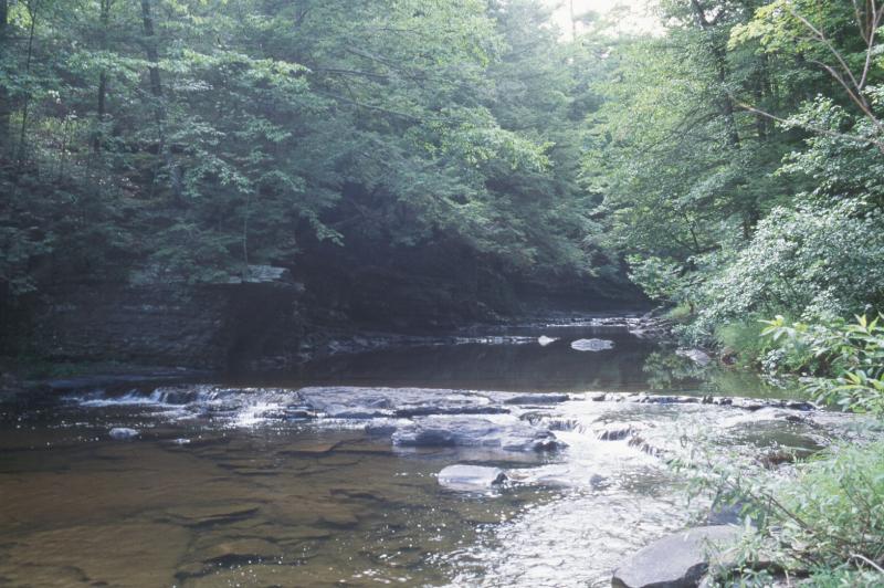
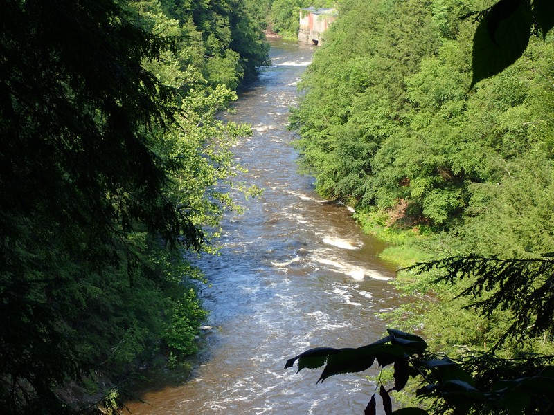
Confined river at Plattekill Creek
Andy Finton
- System
- Riverine
- Subsystem
- Natural Streams
- State Protection
- Not Listed
Not listed or protected by New York State.
- Federal Protection
- Not Listed
- State Conservation Status Rank
- S3S4
Vulnerable in New York, or Apparently Secure - Vulnerable to disappearing from New York (but not currently imperiled), with relatively few populations or locations, few individuals, and/or restricted range; or uncommon but not rare in New York; may be rare in some parts of the state; possibly some cause for long-term concern due to declines or other factors. More information is needed to assign either S3 or S4.
- Global Conservation Status Rank
- G4
Apparently Secure globally - Uncommon in the world but not rare; usually widespread, but may be rare in some parts of its range; possibly some cause for long-term concern due to declines or other factors.
Summary
Did you know?
Common features of confined rivers include plunge pools, flumes, chutes, cascades, alluvial fans, and mussel beds. The predominant source of energy is generated in the stream. These streams have high water clarity, are well oxygenated, and typically have cool water.
State Ranking Justification
There are probably several hundred occurrences statewide. Many documented occurrences have good viability and are protected on public land or private conservation land. This community has statewide distribution, and includes several high quality examples. The current trend of this community is probably stable for occurrences on public land, or declining slightly elsewhere due to moderate threats related to development pressure or alteration to the natural hydrology.
Short-term Trends
The number and miles of confined rivers in New York have probably remained stable in recent decades as a result of water quality regulations. Several examples have shown improvement in water quality in recent decades attributed to improved treatment of municipal and industrial waste (Bode et al. 1993).
Long-term Trends
The number and miles of confined rivers in New York are probably comparable to historical numbers, but the water quality of several of these rivers has likely declined significantly prior to the enforcement of water quality regulations (New York State Department of Environmental Conservation, Division of Water 2000).
Conservation and Management
Threats
Confined rivers are threatened by development and its associated run-off (e.g., residential, agricultural, roads, bridges), recreational overuse (e.g., ATVs, intensive fish stocking and removal), and habitat alteration in the adjacent landscape (e.g., excessive logging, instream gravel mining, pollution run-off). In addition, alteration to the natural hydrology (e.g., impoundments, ditching, stream channelization, dredging, canals), spread of non-native invasive species, and reduction in water quality (e.g., siltation, trash, turbidity, septic/nutrient run-off) are threats to confined river communities. Agricultural activity is the most frequently cited nonpoint source of water quality impact and use impairment to New York State rivers (New York State Department of Environmental Conservation, Division of Water 2000).
Conservation Strategies and Management Practices
Where practical, establish and maintain a riparian buffer to reduce storm-water, pollution, and nutrient run-off, while simultaneously capturing sediments before they reach the river. Buffer width should take into account the erodibility of the surrounding soils, slope steepness, and current land use. If possible, minimize the number and size of impervious surfaces in the surrounding landscape. Avoid habitat alteration within the river and surrounding landscape. For example, roads should not be routed through the riparian buffer area. If the river must be crossed, then bridges and boardwalks are preferred over filling and culverts. Restore past impacts, such as removing obsolete impoundments and ditches in order to restore the natural hydrology. Prevent the spread of invasive exotic species into the river through appropriate direct management, and by minimizing potential dispersal corridors.
Development and Mitigation Considerations
When considering road construction and other development activities, minimize actions that will change what water carries and how water travels to this community, both on the surface and underground. Water traveling over-the-ground as runoff usually carries an abundance of silt, clay, and other particulates during (and often after) a construction project. While still suspended in the water, these particulates make it difficult for aquatic animals to find food; after settling to the bottom of the system, they bury small plants and animals and alter the natural functions of the community in many other ways. Thus, road construction and development activities near this community type should strive to minimize particulate-laden run-off into this community. Water traveling on the ground or seeping through the ground also carries dissolved minerals and chemicals. Road salt, for example, is becoming an increasing problem both to natural communities and as a contaminant in household wells. Fertilizers, detergents, and other chemicals that increase the nutrient levels in wetlands cause algal blooms and eventually an oxygen-depleted environment in which few animals can live. Herbicides and pesticides often travel far from where they are applied and have lasting effects on the quality of the natural community. So, road construction and other development activities should strive to consider: 1. how water moves through the ground, 2. the types of dissolved substances these development activities may release, and 3. how to minimize the potential for these dissolved substances to reach this natural community.
Inventory Needs
Survey for occurrences statewide to advance documentation and classification of confined rivers. A statewide review of confined rivers is desirable. Continue searching for large rivers in good condition (A- to AB-ranked).
Research Needs
There is a need to research the composition of confined rivers statewide in order to characterize variations. In addition, there is a need to collect sufficient quantitative data to support the recognition of several distinct types of confined rivers based on composition and by ecoregion.
Rare Species
- Actinonaias ligamentina (Mucket) (guide)
- Alasmidonta heterodon (Dwarf Wedgemussel) (guide)
- Alasmidonta varicosa (Brook Floater) (guide)
- Amblema plicata (Threeridge) (guide)
- Apalone spinifera (Spiny Softshell) (guide)
- Argia tibialis (Blue-tipped Dancer) (guide)
- Argia translata (Dusky Dancer) (guide)
- Cryptobranchus alleganiensis (Hellbender) (guide)
- Erimystax dissimilis (Streamline Chub) (guide)
- Erimystax x-punctatus (Gravel Chub) (guide)
- Etheostoma camurum (Bluebreast Darter) (guide)
- Eurylophella bicoloroides (Nova Scotia Spiny Crawler Mayfly) (guide)
- Exoglossum laurae (Tonguetied Minnow) (guide)
- Gomphurus fraternus (Midland Clubtail) (guide)
- Gomphurus septima delawarensis (Delaware River Clubtail) (guide)
- Hiodon tergisus (Mooneye) (guide)
- Hylogomphus abbreviatus (Spine-crowned Clubtail) (guide)
- Hylogomphus viridifrons (Green-faced Clubtail) (guide)
- Ichthyomyzon bdellium (Ohio Lamprey) (guide)
- Ichthyomyzon fossor (Northern Brook Lamprey) (guide)
- Ichthyomyzon greeleyi (Mountain Brook Lamprey) (guide)
- Isoetes riparia (Riverbank Quillwort) (guide)
- Lampsilis cariosa (Yellow Lampmussel) (guide)
- Lampsilis fasciola (Wavyrayed Lampmussel) (guide)
- Lanthus vernalis (Southern Pygmy Clubtail) (guide)
- Lasmigona subviridis (Green Floater) (guide)
- Lepomis peltastes (Northern Sunfish) (guide)
- Ligumia nasuta (Eastern Pondmussel) (guide)
- Ligumia recta (Black Sandshell) (guide)
- Lota lota (Burbot) (guide)
- Margaritifera margaritifera (Eastern Pearlshell) (guide)
- Neurocordulia michaeli (Broad-tailed Shadowdragon) (guide)
- Notropis amoenus (Comely Shiner) (guide)
- Notropis bifrenatus (Bridle Shiner) (guide)
- Notropis photogenis (Silver Shiner) (guide)
- Notropis procne (Swallowtail Shiner) (guide)
- Ophiogomphus anomalus (Extra-striped Snaketail) (guide)
- Ophiogomphus aspersus (Brook Snaketail) (guide)
- Ophiogomphus howei (Pygmy Snaketail) (guide)
- Percina macrocephala (Longhead Darter) (guide)
- Phanogomphus quadricolor (Rapids Clubtail) (guide)
- Podostemum ceratophyllum (Riverweed) (guide)
- Potamogeton alpinus (Red Pondweed) (guide)
- Progomphus obscurus (Common Sanddragon) (guide)
- Ptychobranchus fasciolaris (Kidneyshell) (guide)
- Regina septemvittata (Queen Snake) (guide)
- Stuckenia filiformis ssp. occidentalis (Sheathed Pondweed) (guide)
- Utaperla gaspesiana (Gaspe Sallfly) (guide)
- Utterbackiana implicata (Alewife Floater) (guide)
- Villosa fabalis (Rayed Bean) (guide)
Range
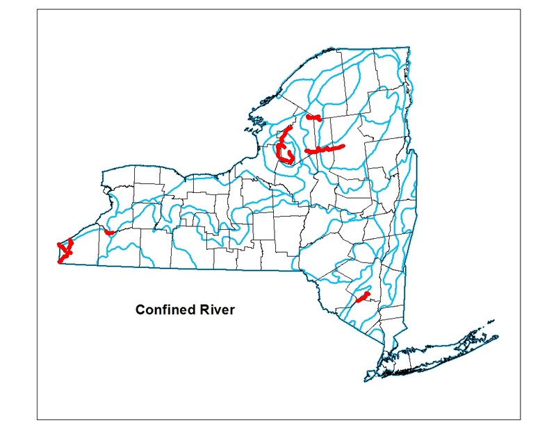
New York State Distribution
Confined rivers are widespread throughout New York State and likely represented by different variants corresponding to major watersheds and ecoregions.
Global Distribution
This broadly-defined community may be worldwide. Examples with the greatest biotic affinities to New York occurrences are suspected to span north to southern Canada, west to Minnesota, southwest to Indiana and Tennessee, and southeast to Georgia.
Best Places to See
- French Creek
- Upper Hudson River from Newcomb to Glens Falls (Essex, Hamilton, Saratoga, Warren Counties)
- Upper Delaware River (Sullivan County)
- Hoosic River (Rensselaer County)
- Moose River (Herkimer, Lewis, Oneida Counties)
- East Branch Fish Creek (Lewis County)
- Shawangunk Kill (Ulster County)
- Cattaraugus River Zoar Valley
- Middle Branch Oswegatchie River (Herkimer, Lewis, St. Lawrence Counties)
- Roundout Creek (Ulster County)
Identification Comments
General Description
Confined rivers are relatively large, fast flowing sections of streams with a moderate to gentle gradient. They have a well-defined pattern of alternating pools, riffles, and runs, and usually have poorly defined meanders (i.e., low sinuosity). Confined rivers occur in confined valleys and are most typical of the midreaches of stream systems. These streams are typically of moderate depth, width, and low flow discharge, and usually represent a network of third- to fourth-order stream segments. Most of the erosion is lateral, creating braids, channel islands, and bars, and deposition is moderate with a mix of coarse rocky to sandy substrate. Waterfalls are often present. Other features include plunge pools, flumes, chutes, cascades, alluvial fans, and mussel beds. These streams have high water clarity, are well oxygenated, and have cool water. They are typically surrounded by open upland riverside communities including riverside sand/gravel bar, cobble shore, or one of the shoreline outcrop communities. Characteristic fishes include creek chub (Semotilus atromaculatus), pumpkinseed (Lepomis gibbosus), common shiner (Luxilus cornutus), and trout-perch (Percopsis omiscomaycus) in pools; rosyface shiner (Notropis rubellus) at the head of pools; tessellated darter (Etheostoma olmstedi), longnose dace (Rhinichthys cataractae), slimy sculpin (Cottus cognatus) or mottled sculpin (C. bairdi), and stonecat (Noturus flavus) in riffles; and bluntnose minnow (Pimephales notatus) and northern hogsucker (Hypentelium nigricans) in runs. Common introductions are rainbow trout (Salmo gairdneri) and brown trout (S. trutta). Characteristic mollusks include eastern elliptio (Elliptio complanta), eastern floater (Pyganodon cataracta), and fingernail clams (Sphaerium spp.). A diversity of other macroinvertebrates are present, including abundant net-spinning caddisflies (Hydropsychidae); riffle and rocky bottom specialists as well as algae shredders such as crayfish (Cambaridae), mayflies (Ephemeroptera including Ephemeridae, Heptageniidae, Baetidae, Isonychia spp., Eurylophella spp.), stoneflies (Plecoptera including Chloroperlidae, Perlidae), caddisflies (Trichoptera including Hydropsychidae, Helicopsyche spp., Dolophilodes spp., Rhyacophila spp., Nectopsyche spp., Psilotreta spp., Glossosoma spp., Brachycentrus spp., Neophylax spp., Goera spp.), beetles (Elmidae, Psephenus spp.), dobsonflies (Corydalidae), midges (Polypedilum spp.), craneflies (Hexatoma spp., Tipulidae including Hexatoma spp.), and blackflies (Simulidae). Odonate (Odonata including Calopteryidae) larvae may be characteristic of runs. True bugs (Gerridae, Vellidae, Mesovellidae) are characteristic of pools. Epilithic algae are present, often at moderate percent cover. Aquatic macrophytes are usually sparse. Typical aquatic macrophytes include waterweed (Elodea canadensis) and linear-leaved pondweeds such as sago pondweed (Stuckenia pectinatus). An additional characteristic vascular plant may be riverweed (Podostemum ceratophyllum). Bryophytes such as the moss Grimmia alpicola var. rivularis are often confined to shallows and the intermittently exposed channel perimeter.
Characters Most Useful for Identification
The aquatic community of relatively large, fast flowing sections of streams with a moderate to gentle gradient. Confined rivers usually represent a network of third- to fourth-order stream segments, and waterfalls are typically present. Confined rivers are generally depicted as a double line on 7.5 minute USGS topgraphic maps (starting where streams transition from single to double line at 1:24,000 scale).
Elevation Range
Known examples of this community have been found at elevations between 195 feet and 2,145 feet.
Best Time to See
The waterfalls and fast-flowing riffles of confined rivers are especially dramatic in the spring when snow melts in the uplands and surges into rivers.
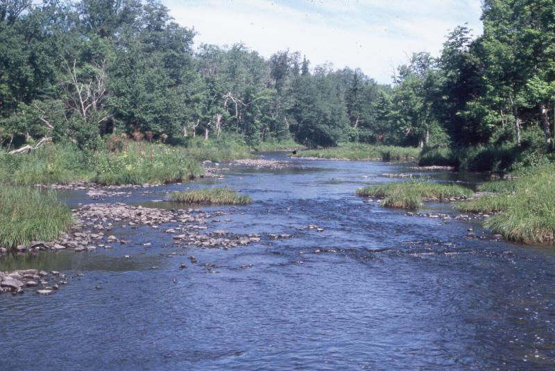
Confined River Images
Andy Finton
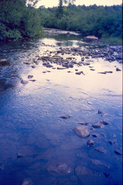
David M. Hunt
David M. Hunt
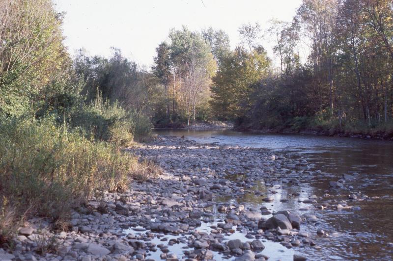
Gregory J. Edinger
Gregory J. Edinger
Classification
Characteristic Species
-
Nonvascular plants
- Grimmia alpicola rivularis
-
Emergent aquatics
- Podostemum ceratophyllum (riverweed, thread-foot)
- Potamogeton epihydrus (ribbon-leaved pondweed)
- Schoenoplectus subterminalis (water bulrush)
- Sparganium angustifolium (narrow-leaved bur-reed)
-
Submerged aquatics
- Elodea canadensis (Canada waterweed)
- Potamogeton spirillus (northern snailseed pondweed)
- Stuckenia pectinata (Sago pondweed)
Similar Ecological Communities
- Marsh headwater stream
(guide)
Marsh headwater streams typically flow along or between wetlands (e.g., marshes, bogs, swamps) while confined rivers are generally larger and tend to flow through terrestrial communities. Marsh headwater streams typically occur upstream of confined rivers.
- Rocky headwater stream
(guide)
Confined rivers are generally larger than rocky headwater streams; they tend to have a lower gradient and higher water volume. Rocky headwater streams typically occur upstream of confined rivers.
- Unconfined river
(guide)
Unconfined rivers generally occur downstream of confined rivers. They are also larger and have more meanders (higher sinuosity) than confined rivers.
Vegetation
Percent cover
This figure helps visualize the structure and "look" or "feel" of a typical Confined River. Each bar represents the amount of "coverage" for all the species growing at that height. Because layers overlap (shrubs may grow under trees, for example), the shaded regions can add up to more than 100%.
Additional Resources
References
Bode, R.W., M.A. Novak, and L.E. Abele. 1993. Twenty year trends in water quality of rivers and streams in New York State based on macroinvertebrate data 1972-1992. New York Department of Environmental Conservation, Division of Water, Albany, NY.
Edinger, G. J., D. J. Evans, S. Gebauer, T. G. Howard, D. M. Hunt, and A. M. Olivero (editors). 2014. Ecological Communities of New York State. Second Edition. A revised and expanded edition of Carol Reschke’s Ecological Communities of New York State. New York Natural Heritage Program, New York State Department of Environmental Conservation, Albany, NY. https://www.nynhp.org/ecological-communities/
Edinger, Gregory J., D.J. Evans, Shane Gebauer, Timothy G. Howard, David M. Hunt, and Adele M. Olivero (editors). 2002. Ecological Communities of New York State. Second Edition. A revised and expanded edition of Carol Reschke's Ecological Communities of New York State. (Draft for review). New York Natural Heritage Program, New York State Department of Environmental Conservation. Albany, NY. 136 pp.
New York Department of Environmental Conservation, Division of Water. 2000. New York State water quality 2000. October 2000. New York Department of Environmental Conservation, Division of Water, Albany, NY.
New York Natural Heritage Program. 2024. New York Natural Heritage Program Databases. Albany, NY.
New York Natural Heritage Program. No date. Field forms database: Electronic field data storage and access for New York Heritage ecology, botany, and zoology. New York Natural Heritage Program, New York State Department of Environmental Conservation. Albany, NY.
Reschke, Carol. 1990. Ecological communities of New York State. New York Natural Heritage Program, New York State Department of Environmental Conservation. Latham, NY. 96 pp. plus xi.
Smith, C.L. 1985. The Inland Fishes of New York State. New York State Department of Environmental Conservation. Albany, NY. 522pp.
Links
About This Guide
Information for this guide was last updated on: December 27, 2023
Please cite this page as:
New York Natural Heritage Program. 2024.
Online Conservation Guide for
Confined river.
Available from: https://guides.nynhp.org/confined-river/.
Accessed July 27, 2024.