Maritime Grassland
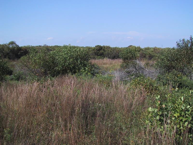
Maritime grassland at Shadmoor State Park
Aissa L. Feldmann
- System
- Terrestrial
- Subsystem
- Open Uplands
- State Protection
- Not Listed
Not listed or protected by New York State.
- Federal Protection
- Not Listed
- State Conservation Status Rank
- S1
Critically Imperiled in New York - Especially vulnerable to disappearing from New York due to extreme rarity or other factors; typically 5 or fewer populations or locations in New York, very few individuals, very restricted range, very few remaining acres (or miles of stream), and/or very steep declines.
- Global Conservation Status Rank
- G2G3
Imperiled or Vulnerable globally - At high or moderate risk of extinction due to rarity or other factors; typically 80 or fewer populations or locations in the world, few individuals, restricted range, few remaining acres (or miles of stream), and/or recent and widespread declines. More information is needed to assign either G2 or G3.
Summary
Did you know?
From Stack (1989): "Early 19th century maps and photos show that nearly the entire eastern end of Long Island was once covered with tallgrass prairie-like vegetation. The grasslands supported large herds of grazing animals driven there from as far away as East Hampton to summer on the rich pasture. Annual burning in addition to cattle and sheep grazing kept woody species like bayberry, sumac, cherry, and locust from establising in the community. There are records that suggest that this (burning) was a practice learned from the previous inhabitants of the area, the Montauk Indians."
State Ranking Justification
Some of the documented occurrences of this community have good viability and several are protected on public or private conservation land. The community is restricted to the Coastal Lowlands ecozone of eastern Long Island in Suffolk County and is found primarily on the South Fork. The trend for the community is declining due to significant threats from development, fire suppression, and trampling.
Short-term Trends
The number, extent, and viability of maritime grasslands is suspected to have decreased in the recent past, primarily due to fire suppression, woody species proliferation, and exotic species invasion. Some patches do still undergo prescribed burning and an effort has been made to add fire to managment regimes, but the efforts may not be sufficient to maintain stable acreage. Continued development pressures have contributed to additional declines.
Long-term Trends
The number, extent, and viability of maritime grassland in New York are suspected to have declined substantially over the long-term. These declines are likely correlated with fire suppression and decreased grazing, which historically kept woody species at bay. Declines are also due to coastal development and associated changes in landscape connectivity and natural processes.
Conservation and Management
Threats
Maritime grassland is threatened by increasing development pressure, fire suppression leading to woody species success, and trampling. Establishment and spread of invasive exotic species (Anthoxanthum odoratum, Celastrus orbiculatus, Lonicera morrowii, Setaria sp., Pinus thunbergii, and Agrostis sp.) is also a threat to this community. Some occurrences are threatened by ORV damage and herbicide use along railroad lines.
Conservation Strategies and Management Practices
Restore and replicate the natural fire regime, as appropriate. Monitor for trampling damage. Monitor the abundance of invasive species in this community and, as needed, control their encroachment using non-chemical protocols; in particular, restrict herbicide spraying along railroad tracks.
Development and Mitigation Considerations
This community is best protected as part of a large maritime system, encompassing grasslands, shrublands, bluffs, heathland, forests, barrens, and dunes. Development should avoid fragmentation of such systems to allow for nutrient flow, seed dispersal, and seasonal animal migrations within them. Bisecting trails, roads, and developments can also allow exotic plant and animal species to invade and potentially increase 'edge species' (such as raccoons, skunks, and foxes). Connectivity to brackish and freshwater tidal communities and to shallow offshore communities should also be maintained as much as possible to maintain "maritime" conditions, which imply deposition of salt spray and shearing from offshore winds.
Inventory Needs
The community has been well-inventoried, but additional occurrences may be found using aerial surveys. More compositional data, including plot data collection, is needed, as is data on rare and characteristic animals.
Research Needs
Documentation of the natural fire regime of this community is needed, possibly using the sources referred to in Stack (1989). Early records (from the 1650's) show that the grasslands were burned frequently (at times annually) by the Montauk Indians and subsequently by early settlers (Stack 1989). An investigation into the taxonomic distinction between maritime grassland and the stabilized, graminoid-dominated maritime dune variant is needed, as these communities can be essentially identical in species composition, structure, and function. They need further documentation, analysis, and clarification.
Rare Species
- Abagrotis benjamini (Coastal Heathland Cutworm) (guide)
- Agalinis decemloba (Sandplain Agalinis) (guide)
- Aletris farinosa (White Colicroot) (guide)
- Amelanchier nantucketensis (Nantucket Juneberry) (guide)
- Ammodramus henslowii (Henslow's Sparrow) (guide)
- Apamea burgessi (Burgess's Apamea) (guide)
- Asclepias viridiflora (Green Milkweed) (guide)
- Carex emmonsii (Emmons' Sedge) (guide)
- Carex mesochorea (Midland Sedge) (guide)
- Cenchrus tribuloides (Dune Sandspur) (guide)
- Circus hudsonius (Northern Harrier) (guide)
- Cisthene packardii (Packard's Lichen Moth) (guide)
- Crocanthemum dumosum (Bushy Rock Rose) (guide)
- Cyperus retrorsus var. retrorsus (Retrorse Flatsedge) (guide)
- Dargida rubripennis (The Pink Streak) (guide)
- Desmodium obtusum (Rigid Tick Trefoil) (guide)
- Dichagyris acclivis (Switchgrass Dart) (guide)
- Eacles imperialis imperialis (Imperial Moth) (guide)
- Empetrum nigrum (Black Crowberry) (guide)
- Eucoptocnemis fimbriaris (Fringed Dart) (guide)
- Eupatorium torreyanum (Torrey's Thoroughwort) (guide)
- Eurybia spectabilis (Showy Aster) (guide)
- Euxoa pleuritica (Fawn Brown Dart) (guide)
- Euxoa violaris (Violet Dart) (guide)
- Hydraecia stramentosa (Hairy Hydraecia) (guide)
- Hypomecis umbrosaria (Umber Moth) (guide)
- Liatris scariosa var. novae-angliae (Northern Blazing Star) (guide)
- Linum intercursum (Sandplain Wild Flax) (guide)
- Lithospermum virginianum (Virginia False Gromwell) (guide)
- Marimatha nigrofimbria (Black-bordered Lemon Moth) (guide)
- Oenothera laciniata (Cut-leaved Evening Primrose) (guide)
- Oligia bridghamii (Bridgham's Brocade) (guide)
- Parasa indetermina (Stinging Rose Caterpillar Moth) (guide)
- Paspalum laeve (Field Bead Grass) (guide)
- Pycnanthemum muticum (Blunt Mountain Mint) (guide)
- Pycnanthemum verticillatum var. verticillatum (Whorled Mountain Mint) (guide)
- Quercus phellos (Willow Oak) (guide)
- Renia nemoralis (Chocolate Renia) (guide)
- Satyrium edwardsii (Edwards' Hairstreak) (guide)
- Silene caroliniana ssp. pensylvanica (Wild Pink) (guide)
- Sisyrinchium mucronatum (Sharp-tipped Blue-eyed Grass) (guide)
- Spiranthes vernalis (Grass-leaved Ladies' Tresses) (guide)
- Sympistis riparia (Dune Sympistis) (guide)
- Tyto alba (Barn Owl) (guide)
- Viburnum dentatum var. venosum (Southern Arrowwood) (guide)
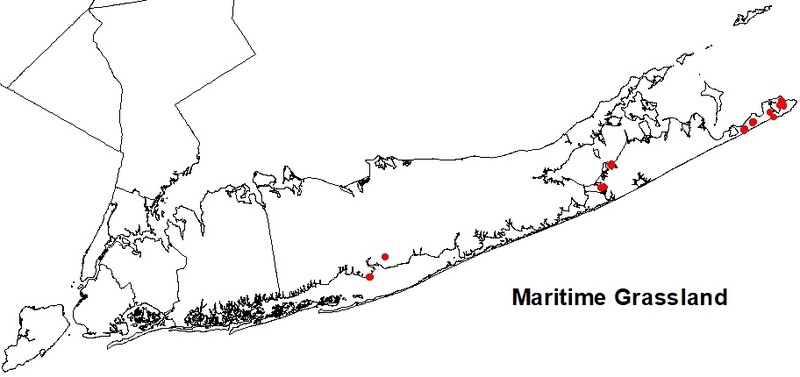
Range
New York State Distribution
This community is restricted to the Coastal Lowlands ecozone of eastern Long Island in Suffolk County on the South Fork and vicinity. The historical range may have extended west to Nassau County, where the community may have graded into Hempstead Plains grassland.
Global Distribution
This community occurs in patches along the northeastern seacoast and on offshore islands of Massachusetts, Rhode Island, and New York (NatureServe 2009).
Best Places to See
- Montauk Point State Park (Suffolk County)
- Shadmoor State Park (Suffolk County)
- Hither Hills State Park (Suffolk County)
Identification Comments
General Description
A grassland community that occurs on rolling outwash plains of the glaciated portion of the Atlantic coastal plain, near the ocean, and within the influence of offshore winds and salt spray. This community is dominated by grasses that usually form a turf; the grasses collectively have greater than 50% cover. Low heath shrubs may be present, with less than 50% cover.
Characters Most Useful for Identification
The dominant grasses are little bluestem (Schizachyrium scoparium), common hairgrass (Deschampsia flexuosa), and poverty-grass (Danthonia spicata). Other characteristic species include Pennsylvania sedge (Carex pensylvanica), rush (Juncus greenei), Indian grass (Sorghastrum nutans), Atlantic golden aster (Pityopsis falcata), bushy rockrose (Helianthemum dumosum), hoary frostweed (H. propinquum), grass-leaved goldenrod (Euthamia graminifolia), white-topped aster (Sericocarpus asteroides), pussy's-toes (Antennaria plantaginifolia), bitter milkwort (Polygala polygama), hyssop-leaved boneset (Eupatorium hyssopifolium), bayberry (Myrica pensylvanica), shining sumac (Rhus copallinum), and northern dewberry (Rubus flagellaris). Rare plants occuring in some maritime grasslands are (Agalinis acuta) and New England blazing star (Liatris scariosa var. novae-angliae). A characteristic lichen is reindeer lichen (Cladonia rangiferina).
Elevation Range
Known examples of this community have been found at elevations between 1 feet and 90 feet.
Best Time to See
One of the best times to see maritime grasslands is in the fall after the first frost, when the grasses have turned from green to their distinct late season reds and purples. Early fall is also a good time to enjoy asters and goldenrods in bloom.
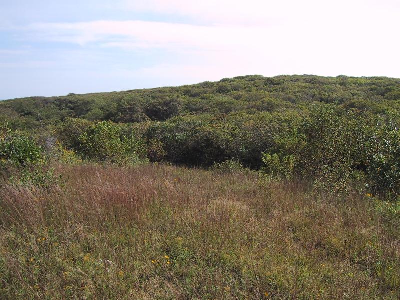
Maritime Grassland Images
Aissa L. Feldmann
Aissa L. Feldmann
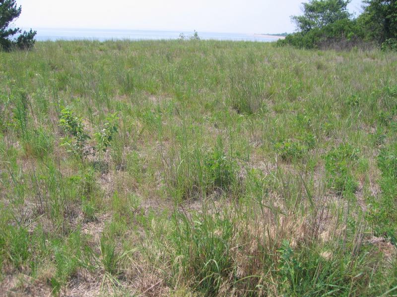
Gregory J. Edinger
Classification
International Vegetation Classification Associations
This New York natural community encompasses all or part of the concept of the following International Vegetation Classification (IVC) natural community associations. These are often described at finer resolution than New York's natural communities. The IVC is developed and maintained by NatureServe.
- Northern Bayberry / Shore Little Bluestem - Poverty Oatgrass Shrub Grassland (CEGL006067)
NatureServe Ecological Systems
This New York natural community falls into the following ecological system(s). Ecological systems are often described at a coarser resolution than New York's natural communities and tend to represent clusters of associations found in similar environments. The ecological systems project is developed and maintained by NatureServe.
- Northern Atlantic Coastal Plain Heathland and Grassland (CES203.895)
Characteristic Species
-
Shrubs < 2m
- Morella caroliniensis (bayberry)
- Rhus copallinum var. copallinum (common winged sumac)
-
Tree saplings
- Prunus serotina var. serotina (wild black cherry)
-
Vines
- Rubus flagellaris (northern dewberry)
-
Herbs
- Antennaria plantaginifolia (plantain-leaved pussy-toes)
- Artemisia vulgaris (mugwort)
- Avenella flexuosa (common hair grass)
- Baptisia tinctoria (wild-indigo)
- Carex pensylvanica (Pennsylvania sedge)
- Crocanthemum dumosum (bushy frostweed, bushy rock-rose)
- Crocanthemum propinquum (low frostweed, low rock-rose)
- Danthonia spicata (poverty grass)
- Eragrostis spectabilis (purple love grass)
- Eupatorium hyssopifolium (hyssop-leaved thoroughwort)
- Euthamia graminifolia (common flat-topped-goldenrod)
- Pityopsis falcata (sickle-leaved golden-aster)
- Polygala polygama (bitter milkwort)
- Schizachyrium scoparium var. scoparium (little bluestem)
- Sericocarpus asteroides (toothed white-topped-aster)
- Solidago rugosa var. rugosa (common wrinkle-leaved goldenrod)
- Sorghastrum nutans (Indian grass)
-
Nonvascular plants
- Gray reindeer lichen (Cladonia rangiferina)
Similar Ecological Communities
- Hempstead Plains grassland
(guide)
Hempstead Plains grassland occurs inland, beyond the influence of offshore winds and salt spray, and is dominated by species characteristic of midwestern tallgrass prairies: big bluestem (Andropogon gerardii), little bluestem, Indian grass, and switchgrass (Panicum virgatum). Maritime grassland occurs near the ocean within the range of offshore winds and salt spray and is dominated by little bluestem, common hairgrass, and poverty-grass.
- Maritime dunes
(guide)
Maritime dunes occur on active and stabilized sand dunes along the Atlantic coast. Active dunes are characterized by a near monoculture of beachgrass (Ammophila breviligulata) and more stable areas can support a variety of species, some of which (like little bluestem) can also be found in maritime grasslands. Maritime grasslands are located on the deeper soils of rolling outwash plains (not on sandy dunes) further from the ocean but still within the range of offshore winds and salt spray. They are characterized by the grasses little bluestem, common hairgrass, and poverty-grass.
- Successional northern sandplain grassland
(guide)
While these communities may share similar species, successional northern sandplain grasslands occur on sandy soil and are dominated by bluestem (Schizachyrium scoparium), hairgrass (Avenella flexuosa), Pennsylvania sedge (Carex pensylvanica), poverty grass (Danthonia spicata), and panic grasses (Dichanthelium spp.). Maritime grasslands occur on rolling outwash plains of the glaciated portion of the coastal plain, near the ocean and within the influence of offshore winds and salt spray. They are dominated by little bluestem (Schizachyrium scoparium), common hairgrass (Avenella flexuosa), and poverty-grass (Danthonia spicata).
Vegetation
Percent cover
This figure helps visualize the structure and "look" or "feel" of a typical Maritime Grassland. Each bar represents the amount of "coverage" for all the species growing at that height. Because layers overlap (shrubs may grow under trees, for example), the shaded regions can add up to more than 100%.
Additional Resources
References
Dunwiddie, P. W., R. E. Zaremba, and K. A. Harper. 1996. A classification of coastal heathlands and sandplain grasslands in Massachusetts. Rhodora 98(894):117-145.
Edinger, G. J., D. J. Evans, S. Gebauer, T. G. Howard, D. M. Hunt, and A. M. Olivero (editors). 2014. Ecological Communities of New York State. Second Edition. A revised and expanded edition of Carol Reschke’s Ecological Communities of New York State. New York Natural Heritage Program, New York State Department of Environmental Conservation, Albany, NY. https://www.nynhp.org/ecological-communities/
Edinger, Gregory J., D.J. Evans, Shane Gebauer, Timothy G. Howard, David M. Hunt, and Adele M. Olivero (editors). 2002. Ecological Communities of New York State. Second Edition. A revised and expanded edition of Carol Reschke's Ecological Communities of New York State. (Draft for review). New York Natural Heritage Program, New York State Department of Environmental Conservation. Albany, NY. 136 pp.
Grossman, D. H., K. Lemon Goodin, and C. L. Reuss, editors. 1994. Rare plant communities of the conterminous United States: An initial survey. The Nature Conservancy. Arlington, VA. 620 pp.
NatureServe. 2015. NatureServe Explorer: An online encyclopedia of life [web application]. Version 7.1. NatureServe, Arlington, Virginia. Available http://www.natureserve.org/explorer.
New York Natural Heritage Program. 2024. New York Natural Heritage Program Databases. Albany, NY.
Reschke, Carol. 1990. Ecological communities of New York State. New York Natural Heritage Program, New York State Department of Environmental Conservation. Latham, NY. 96 pp. plus xi.
Stack, L. 1989. A fire History and Justification for The Maritime Grasslands of Eastern Long Island. Presented to The Nature Conservancy, New York Field Office, Albany, NY.
Taylor, N. 1923. The vegetation of Montauk. A study of grassland and forest. Brooklyn Botanic Garden Memoirs 2: 1-107.
Thompson, John E. 1997. Ecological communities of the Montauk Peninsula, Suffolk County, New York. Prepared for The Nature Conservancy, Long Island Chapter. April 1997.
Links
About This Guide
This guide was authored by: Aissa Feldmann
Information for this guide was last updated on: December 12, 2023
Please cite this page as:
New York Natural Heritage Program. 2024.
Online Conservation Guide for
Maritime grassland.
Available from: https://guides.nynhp.org/maritime-grassland/.
Accessed July 26, 2024.